


 Feel free to hang out and lurk as long as you like. However, we would like to encourage you to
 - Joined
- Jan 1, 2005
- Messages
- 4,465
- Reaction score
- 1,228
- Location
- Buda, TX
- First Name
- Rich
- Last Name
- Gibbens
One day tour of some fun, twisty, scenic hill country backroads starting in Austin, having lunch in Boerne, and then returning to Austin. All the roads on this trip are paved and can be easily done with any street bike. There are some low water crossings, so if rain has occurred lately you may enjoy a little extra adventure.
1. Starting from the cycle famous "Y" in Oak Hill head west on Hwy 290 for 1 mile.
(The "Y" in Oak Hill is a common meeting location for cyclists headed out on rides around Central Texas. It is located in southwest Austin at the intersection of Hwy 290 west and Hwy 71.)
2. Turn left onto RR 1826 (the road that leads to the Salt Lick BBQ - mmmmm) for 12 miles.
3. Turn right on FM 150 and ride 5.2 miles to FM 12. Turn right on FM 12 for 1.7 miles to the intersection of FM 12 and Hwy 290 in Dripping Springs.
4. Turn left (west) onto Hwy 290 for .3 mile.
5. Turn left onto Creek Rd / CR 190 (sign says Creek Rd) for 2.2 miles. At this point the road makes a "y", stay right on Creek Rd / CR 190 for another 6.6 miles. Now things are starting to get interesting - Creek Rd is a sweet, twisty back road.
6. Turn left (west) onto FM 165 for 15.5 miles, arriving in Blanco. FM 165 provides some great views of the hill country. As a bonus you may even spot a few buffalo at one of the ranches on the left side of FM 165.
7. Turn right onto Loop 163 in Blanco for .3 mile.
8. Turn left onto Hwy 281 for .3 mile, driving through downtown Blanco.
9. Turn right onto Park Road 23 as if you are going into Blanco State Park. Instead of entering the park, bear right onto Main Street. Don't get too distracted watching all the swimmers in the park - main street parallels the park. At .2 mile turn left onto CR 102.
10. Go south 18.6 miles on CR 102. Another twisty, curvy, up and down hill country backroad - sweet! Texas seems to name country roads with both names and numbers. The entire length of this road is CR 102 but it also has some name changes throughout this section. At various times it is called Blanco Kendelia Rd, then called Old Blanco Road.
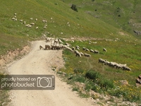
View from CR102 looking southeast

11. Right on FM 473 for 5.3 miles.
12. Left on FM 474 for 16.2 miles to Boerne. This is an excellent cycling road. High speed flowing sweepers, tight curves, nice views, river crossings, and an elevation change or two. You may be tempted to turn around and run it again.
13. Lunch in Boerne. I hear The Daily Grind and the Bear Moon Cafe, both on main street, are good places to eat, but haven't tried them myself. I have, however, eaten at El Rio Mexican Food on River Road / SR 46 and can recommend it.
14. East on SR 46 for 10.2 miles to FM 3351.
15. Left on FM 3351 for 3.6 miles to Edge Falls Rd.
16. Right on Edge Falls Rd for 8.3 miles of twisty, scenic country riding. See if you can spot the oh so enticing blue/green swimming hole on the left.
17. Right on FM 473 for 12 miles of more excellent hill country riding - up, down, and around.
18. Left (north) on Hwy 281 for 1.9 miles
19. Right (east) on FM 473 again for 5.7 miles of more 473 fun.
20. Right on FM 32 for 5.1 miles to the community of Fischer.
21. Left onto Loop 484 for .2 mile to Fischer Store Road.
22. Fischer Store Road for 8.3 miles of more cycling fun.
23. Right on FM 2325 (towards Wimberley) for 1.5 miles to Jacobs Well Road.
24. Left on Jacobs Well Road / CR 220 for 1.3 miles. It gets even more interesting now because of Texas' road naming conventions.
25. Left on CR 220 - except the road sign won't say CR 220. Instead it will say Mt. Gainor. Go 5.8 miles. There are numerous cattle guards and free ranging cattle so be cautious. Cow plop and tires don't mix well.
26. More interesting adventures in road naming. At 5.8 miles CR 244 joins CR 220. Of course neither are named CR 244 or CR 220 since both have road signs indicating their names but not their county road number. In any case, at this intersection turn right (if you mistakenly turn left onto CR 244 you will wind your way back south to FM 2325 near where you got on it in step 23 above).
27. At some point the name changes from Mt. Gainor to Mt. Sharp, but it's still CR 220. Interesting, huh? Anyway, stay on CR 220 for 9.3 miles of lots of fun, twisty, scenic riding. You will pass a few intersections along the way, but it's not all that difficult to figure out which way CR 220 goes and which is another road to another adventure. Take care crossing the one vehicle bridges - don't get caught in the middle at the same time as a rancher pulling a goose neck trailer.
28. Now you are back at the same point you reached in point 5 above - the intersection of CR 220 and CR 190 (Creek Rd). Backtrack on CR 190 for 2.2 miles to Hwy 290 in Dripping Springs.
29. Decision time. Fast route back to Austin and the "Y" in Oak Hill via Hwy 290 for 14.3 miles? Or the scenic route retracing your steps by going south on FM 12 for 1.7 miles to FM 150, then taking FM 150 for 5.3 miles to FM 1826, then taking FM 1826 for 12.1 miles to Hwy 290, and finally turning right on Hwy 290 to get back to the "Y" in Oak Hill? If you take the scenic route maybe you can stop by the Salt Lick for some of their fantastic peach cobler.
1. Starting from the cycle famous "Y" in Oak Hill head west on Hwy 290 for 1 mile.
(The "Y" in Oak Hill is a common meeting location for cyclists headed out on rides around Central Texas. It is located in southwest Austin at the intersection of Hwy 290 west and Hwy 71.)
2. Turn left onto RR 1826 (the road that leads to the Salt Lick BBQ - mmmmm) for 12 miles.
3. Turn right on FM 150 and ride 5.2 miles to FM 12. Turn right on FM 12 for 1.7 miles to the intersection of FM 12 and Hwy 290 in Dripping Springs.
4. Turn left (west) onto Hwy 290 for .3 mile.
5. Turn left onto Creek Rd / CR 190 (sign says Creek Rd) for 2.2 miles. At this point the road makes a "y", stay right on Creek Rd / CR 190 for another 6.6 miles. Now things are starting to get interesting - Creek Rd is a sweet, twisty back road.
6. Turn left (west) onto FM 165 for 15.5 miles, arriving in Blanco. FM 165 provides some great views of the hill country. As a bonus you may even spot a few buffalo at one of the ranches on the left side of FM 165.
7. Turn right onto Loop 163 in Blanco for .3 mile.
8. Turn left onto Hwy 281 for .3 mile, driving through downtown Blanco.
9. Turn right onto Park Road 23 as if you are going into Blanco State Park. Instead of entering the park, bear right onto Main Street. Don't get too distracted watching all the swimmers in the park - main street parallels the park. At .2 mile turn left onto CR 102.
10. Go south 18.6 miles on CR 102. Another twisty, curvy, up and down hill country backroad - sweet! Texas seems to name country roads with both names and numbers. The entire length of this road is CR 102 but it also has some name changes throughout this section. At various times it is called Blanco Kendelia Rd, then called Old Blanco Road.
View from CR102 looking southeast
11. Right on FM 473 for 5.3 miles.
12. Left on FM 474 for 16.2 miles to Boerne. This is an excellent cycling road. High speed flowing sweepers, tight curves, nice views, river crossings, and an elevation change or two. You may be tempted to turn around and run it again.
13. Lunch in Boerne. I hear The Daily Grind and the Bear Moon Cafe, both on main street, are good places to eat, but haven't tried them myself. I have, however, eaten at El Rio Mexican Food on River Road / SR 46 and can recommend it.
14. East on SR 46 for 10.2 miles to FM 3351.
15. Left on FM 3351 for 3.6 miles to Edge Falls Rd.
16. Right on Edge Falls Rd for 8.3 miles of twisty, scenic country riding. See if you can spot the oh so enticing blue/green swimming hole on the left.
17. Right on FM 473 for 12 miles of more excellent hill country riding - up, down, and around.
18. Left (north) on Hwy 281 for 1.9 miles
19. Right (east) on FM 473 again for 5.7 miles of more 473 fun.
20. Right on FM 32 for 5.1 miles to the community of Fischer.
21. Left onto Loop 484 for .2 mile to Fischer Store Road.
22. Fischer Store Road for 8.3 miles of more cycling fun.
23. Right on FM 2325 (towards Wimberley) for 1.5 miles to Jacobs Well Road.
24. Left on Jacobs Well Road / CR 220 for 1.3 miles. It gets even more interesting now because of Texas' road naming conventions.
25. Left on CR 220 - except the road sign won't say CR 220. Instead it will say Mt. Gainor. Go 5.8 miles. There are numerous cattle guards and free ranging cattle so be cautious. Cow plop and tires don't mix well.
26. More interesting adventures in road naming. At 5.8 miles CR 244 joins CR 220. Of course neither are named CR 244 or CR 220 since both have road signs indicating their names but not their county road number. In any case, at this intersection turn right (if you mistakenly turn left onto CR 244 you will wind your way back south to FM 2325 near where you got on it in step 23 above).
27. At some point the name changes from Mt. Gainor to Mt. Sharp, but it's still CR 220. Interesting, huh? Anyway, stay on CR 220 for 9.3 miles of lots of fun, twisty, scenic riding. You will pass a few intersections along the way, but it's not all that difficult to figure out which way CR 220 goes and which is another road to another adventure. Take care crossing the one vehicle bridges - don't get caught in the middle at the same time as a rancher pulling a goose neck trailer.
28. Now you are back at the same point you reached in point 5 above - the intersection of CR 220 and CR 190 (Creek Rd). Backtrack on CR 190 for 2.2 miles to Hwy 290 in Dripping Springs.
29. Decision time. Fast route back to Austin and the "Y" in Oak Hill via Hwy 290 for 14.3 miles? Or the scenic route retracing your steps by going south on FM 12 for 1.7 miles to FM 150, then taking FM 150 for 5.3 miles to FM 1826, then taking FM 1826 for 12.1 miles to Hwy 290, and finally turning right on Hwy 290 to get back to the "Y" in Oak Hill? If you take the scenic route maybe you can stop by the Salt Lick for some of their fantastic peach cobler.
Last edited:


