Feel free to hang out and lurk as long as you like. However, we would like to encourage you to
 - Joined
- May 6, 2004
- Messages
- 402
- Reaction score
- 0
- Location
- Raleigh, NC
- First Name
- Chris
- Last Name
- McKendry
27 April Sam Houston National Forest -ride report
I was awaken by a phone call this morning. It's Brian, a friend and co-worker of mine. He rides a CR125 and we've been talking about exploring the multi-use trails in the West-side trailhead of the Sam Houston Nat'l Forest.
I really wanted to go, but my KLX650C was sitting out in the garage, spotless from my 2-day toothbrush cleaning after the awesome Clayton Oklahoma ride last month. I was hesitant to get my ride dirty again so soon . After getting motivated and realizing what a nice, cool day it was going to be, I called Brian back and we agreed to meet at the North parking lot. I put on my riding gear, fired up the KLX and hit the road. It's 19 miles from my house to the north lot. Hwy 105 to Montgomery, about 6 miles, then north on FM149 to FM1375. Then East a few miles to FS208 (FM215?), then North about 1.5 miles to the parking area.
If the following images don't load, then my server is down. Try again later. If a considerable amount of time (months, years) has passed since I first posted this and no images appear, then you're out of luck, and this whole thread can be deleted.")
The KLX fuel tank is full..but Chris' fuel tank isn't! So a quick stop at the Montgomery MacD's to fuel up for the day. I notice a Texas DPS trooper giving some locals a receipt for Highway User Fees while I look out the window of McD's.

Mmmm..how quick can I inhale this?

My baby..1995 Kawasaki KLX650C..cleanest it's been in years...

See? Toothbrush, soap and water, and a rag. And lots of time. Even scrubbed under the fenders and between the spokes!

A few shots while riding up FM149. No traffic!


Here's Brian at the North parking lot. He's already been out and back for a quick spin while I was enroute from home.

Brian's Honda CR125

The KLX, gettin' dirty! Man I love this bike.

Chris-V65Magna-TX and his KLX

One of the numerous bridges thoughout the area

Brian checking the map. Next time I'll have a copy of the good map from the PDF file at the official SHNF website. The copy they provide at the park is lame! We ended up getting lost a couple of times. I brought my GPS but it didn't work too well under the trees, and doesn't have any of the roads or trails in the database. Live and learn.

Most of the trails were single track, with whoops, mud puddles, lots of roots, and a lot of brush reaching out into the path to smite thee! Mostly dirt, quite a bit of sand, and some deep sand. Thankfully it was damp. Due to recent rains the sand was manageable. Overall, a fairly techical trail due to the trees, limited visibility around some corners (have to remember there are other riders out here, but we didn't run across any today). Only one fallen tree across a trail that caused a short detour. Neither one of us wiped out or hit a tree.


Brian powering into the unknown! This series of muddy water puddles went pretty far up the trail. Not too deep, but it was slippery.

It's hard to tell from the pic, but this is a series of deep, long mud puddles, all the way to where Brian is sitting at the next corner.

Taking a breather..


Neither one of us had a mechanical problem...

But this spark plug had enough and cried foul!

Ah yes..general dirtiness! Nothing a hose and toothbrush can't clean up!

Back at our starting point, all in one piece!

That was fun! I'm ready to do it again.

On the way home Brian captured this shot of me at speed on 105.

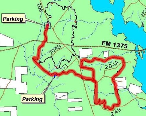
My track of the day. This is as good as it gets. 8 year old Garmin GPSIII PLUS; mapping database is limited at best, and the pine trees do a good job of attenuating the satellite signals. I will be looking at purchasing a RAM mount for my GPS sometime soon. I had it in the tailbag during the ride; it worked great on the paved roads with a little better view of the sky.

We had a great trip! No bruises, broken bones, tickets, mechanical problems..very successful day!
Hope you enjoyed my first attempt at a 'ride report'. See ya DS fans soon!
I was awaken by a phone call this morning. It's Brian, a friend and co-worker of mine. He rides a CR125 and we've been talking about exploring the multi-use trails in the West-side trailhead of the Sam Houston Nat'l Forest.
I really wanted to go, but my KLX650C was sitting out in the garage, spotless from my 2-day toothbrush cleaning after the awesome Clayton Oklahoma ride last month. I was hesitant to get my ride dirty again so soon
. After getting motivated and realizing what a nice, cool day it was going to be, I called Brian back and we agreed to meet at the North parking lot. I put on my riding gear, fired up the KLX and hit the road. It's 19 miles from my house to the north lot. Hwy 105 to Montgomery, about 6 miles, then north on FM149 to FM1375. Then East a few miles to FS208 (FM215?), then North about 1.5 miles to the parking area.If the following images don't load, then my server is down. Try again later. If a considerable amount of time (months, years) has passed since I first posted this and no images appear, then you're out of luck, and this whole thread can be deleted.
The KLX fuel tank is full..but Chris' fuel tank isn't! So a quick stop at the Montgomery MacD's to fuel up for the day. I notice a Texas DPS trooper giving some locals a receipt for Highway User Fees while I look out the window of McD's.
Mmmm..how quick can I inhale this?
My baby..1995 Kawasaki KLX650C..cleanest it's been in years...
See? Toothbrush, soap and water, and a rag. And lots of time. Even scrubbed under the fenders and between the spokes!
A few shots while riding up FM149. No traffic!
Here's Brian at the North parking lot. He's already been out and back for a quick spin while I was enroute from home.
Brian's Honda CR125
The KLX, gettin' dirty! Man I love this bike.
Chris-V65Magna-TX and his KLX
One of the numerous bridges thoughout the area
Brian checking the map. Next time I'll have a copy of the good map from the PDF file at the official SHNF website. The copy they provide at the park is lame! We ended up getting lost a couple of times. I brought my GPS but it didn't work too well under the trees, and doesn't have any of the roads or trails in the database. Live and learn.
Most of the trails were single track, with whoops, mud puddles, lots of roots, and a lot of brush reaching out into the path to smite thee! Mostly dirt, quite a bit of sand, and some deep sand. Thankfully it was damp. Due to recent rains the sand was manageable. Overall, a fairly techical trail due to the trees, limited visibility around some corners (have to remember there are other riders out here, but we didn't run across any today). Only one fallen tree across a trail that caused a short detour. Neither one of us wiped out or hit a tree.
Brian powering into the unknown! This series of muddy water puddles went pretty far up the trail. Not too deep, but it was slippery.
It's hard to tell from the pic, but this is a series of deep, long mud puddles, all the way to where Brian is sitting at the next corner.
Taking a breather..
Neither one of us had a mechanical problem...
But this spark plug had enough and cried foul!
Ah yes..general dirtiness! Nothing a hose and toothbrush can't clean up!
Back at our starting point, all in one piece!
That was fun! I'm ready to do it again.
On the way home Brian captured this shot of me at speed on 105.
My track of the day. This is as good as it gets. 8 year old Garmin GPSIII PLUS; mapping database is limited at best, and the pine trees do a good job of attenuating the satellite signals. I will be looking at purchasing a RAM mount for my GPS sometime soon. I had it in the tailbag during the ride; it worked great on the paved roads with a little better view of the sky.
We had a great trip! No bruises, broken bones, tickets, mechanical problems..very successful day!
Hope you enjoyed my first attempt at a 'ride report'. See ya DS fans soon!
Last edited: