Feel free to hang out and lurk as long as you like. However, we would like to encourage you to
 - Joined
- Nov 7, 2004
- Messages
- 17,425
- Reaction score
- 5,574
- Location
- Sun Lakes & Show Low, Arizona
- First Name
- Brian
A while back my friend Mike and I made plans to ride the Tour Of Honor Extreme SaddleSore for Arizona and grab all seven sites within the 24 hour time frame. If you are not familiar with the organization you can find more details at http://www.tourofhonor.org. Part of the costs to participate is a donation to the Wounded Warrior Project. I spent a lot of time planning out the most effective route because the majority of the route would be two lane secondary roads and many areas would encompass a high density of animals, both wild and tame. There are many areas of the reservations that are Open Range and you never know what you're going to be facing as you come around a blind corner at 2 am. In addition, there have been more trophy elk taken in Arizona than in any other state so you know we grow them big here.
Here is the SPOT tracker from Kayenta to Douglas...

Because Matt Hogan (AZ sponsor) is such a diabolical planner, I could not find a way to start in Phoenix without backtracking at least a couple hundred miles so the decision was made to ride to our starting point in Kayenta on Friday, and then begin the ride Saturday morning. Mike and I met at the Chevron at I-17 and Carefree Hwy and then began our way north. Winds were forecast to be strong but we didn't have much of a problem until we got onto 89 north of Flagstaff. With gusts up to 50 mph we spent most of the northern trek leaned to the left. Once we turned onto 160 and headed to the northeast the wind was to our back and not as much of a problem.
After checking in to our luxurious accommodations (snicker, snicker) at the Anasazi Inn – Tsegi Canyon we made our way in to Kayenta to have an early dinner and get our first photos at the Burger King. This is the site of the Navajo Code Talkers Memorial. While a fast food restaurant would not seem to be the best place for something like this, there was no shortage of visitors to the location while we were there. Not taking any chances, I took the required photo inside, one showing the hours sign indicating that they were closed at 11 pm (our ride was scheduled to begin at 1 am), and a couple of exterior shots to show that we rode there.

Then it was back to the "hotel" to get our Start Of Ride Witness form signed and for six hours of shuteye before the adventure began. The first glitch is that the Navajo Nation in the upper right corner of the state does not adhere to normal Arizona time, so the time on my alarm clock in the room was different from the Goldwing clock. Trying to plan ahead we set the alarm for 1 am the next morning since that would be midnight in the rest of the state. The alarm sounds, we get ready and packed and head into Kayenta for our starting fuel receipt. We both had a receipt start time of 1 am so how much more perfect could that be? But wait, didn't we just wake up at 1 am? So how could the receipt show 1 am when it took us an hour to get there? These questions did not make it through our sleep-muddled brains at that point, but it would come back to haunt us later in the day.
As we are fueling up in Kayenta, a passing motorist wished us Safe Travels and warned us about animals for the next 90 miles. He shook his head in mild disgust at the amount of critters he has seen on these roads at night. Just one more thing for us to be concerned about on this ride.
Although it was 105+ in the Phoenix area just the day before we are expecting some low temps on this ride so heated gear was part of tonight's routine:
Fuel receipt and mileage logged? Check!
Trunk and side bags closed and secured? Check!
Gerbing liner plugged in and on? Check!
Gerbing gloves on? Check!
SPOT on, secured, in Tracking mode? Check!
Headset plugged in and volume adjusted? Check!
Heated grips on? Check!
And then... off we rode. Our route... 160 west passing through Tuba City and then south on 89. Our speeds are low at first and then as I get more comfortable with the reach of my HIDs I open it up a little more. The first scare of the trip comes about half way to Tuba City as a single deer runs across the road in front of me. Knowing that deer tend to not be solitary animals I brake hard, but not hard enough to engage the ABS and my brake modulator flashes a warning to Mike, riding about a hundred yards behind me. He too brakes hard but the one deer was all we saw. Either this one was the tail end of the pack, or he/she was in fact alone. The scare was enough for me to clench my Alaska buttpad between my cheeks and fog up my face shield for a short while. But then soon enough the heart rate subsides and the speeds increase.
We eventually reach 89 and begin to head south past Cameron and the east entrance to the Grand Canyon. At 2:30 in the morning traffic is pretty light but we keep the speeds to no more than 4-9 miles over the limit for “most” of the ride. Any tickets we get on this trip will more than offset any gains in time we would have made by excessive speeds so we keep it reasonable. Nevertheless, the radar detector is in Highway mode and is searching for any stray signals. A new farkle installed the day prior is an LED box that blasts our six red lights instead of allowing the detector to chirp. At higher speeds the chirps are difficult to hear, but in the dead of night those LEDs lighting up will really get your attention in a hurry.
As we approach Flagstaff the altitude begins to increase and temps begin to decrease and I was really happy that I invested in that Gerbing gear last year. We saw a high elevation on this trip of over 7600 feet and soon after that we saw our low temperature of 30 degrees. After leaving Flagstaff and coming down the Rim we saw the temperature increase, but it never got much over 40 degrees. After three hours on the bike and 200+ miles under our wheels we rolled into Camp Verde for our first refueling. Both Mike and I were showing low fuel lights by that time. He was on a Concours 14 (1400 cc) and both that and the 1800 cc Wing are not known for being very fuel efficient at higher speeds.
After gassing up and off-loading some of our own fluids we saddled up and headed for Payson and our next memorial site located next door to the Zane Grey cabin. This memorial is dedicated to those Fire Fighters who battle Arizona's wildfires. We rode Hwy 260 from Camp Verde until it intersects 87 going south to Payson through Strawberry and Pine. This was the first time that I had ridden this section of 260 and it's a great motorcycle road to ride, especially right at sunrise. And what happens at sunrise? Well, the critters start getting active and it becomes time for our next encounters with Arizona wildlife. The first one was a jackrabbit shortly after getting into the twistie portion of 260, and then shortly before reaching the 87 intersection I crested a rise to see two elk standing in the road ahead of me and once again I was hard on the brakes, but they had seen me coming and hustled off the road before I even got close. Knowing that elk, like deer, are pack animals I kept the speeds down again for a while before wicking it back up. We were soon passing through Strawberry and I was lamenting the fact that it was so early in the day and I'd be unable to get a slice of strawberry pie at the Strawberry Lodge. The next town was Pine and everything there was quiet as well and as we reached the Rimside Grill and the speeds increased I was startled to see anywhere from six to a dozen elk on the side of the road, just eating, laying down, and watching the traffic go by.
Down the hill we go into Payson to get our requisite photos and then turn our attention to Phoenix.

We were concerned that the high winds the prior day may have increased the risk to closing 87 (The Beeline) into Phoenix due to the Sunflower Fire, but other than some smoke in the air we were unhampered. It was about 7:00 by the time we reached Phoenix and traffic was starting to pick up. We made our way downtown and to the Wesley Bolin Plaza to get our photo at the anchor from the USS Arizona.

It was fitting that on this day they were prepping the grounds for the annual Fallen Officers event that honors those who have given all to protect the rest of us. Unfortunately we could not wait several hours for this event to start and we needed to get back on the bikes. As we were leaving downtown we were stopped by a passing train so instead of waiting we made a right turn and headed north so that we could grab another westbound cross street to take us to I-17 north. When we reached Grand Ave we sat in the turn lane and then realized it wasn't working, so we moved to a regular lane so we could go through the intersection and then make a u-turn from there. We both realized that if we had just waited for the train to pass we would have not been as far behind on time.
Reaching I-17 we turned north with the intention of heading to Wickenburg. The GPS wanted to route us up Grand Ave (Hwy 60) but I felt that our route may be longer but faster due to not having multiple stop lights along the way. We gassed up at the Chevron at I-17 and Carefree Hwy, the same spot we had left from 22 hours previously, and then started toward Wickenburg. We both had a craving for an Egg McMuffin when we reached the Micky D's in Wickenburg, but our hopes were dashed as we rounded the corner only to see fencing all around the restaurant and a sign out front stating Closed For Remodel. Not wanting to spend time hunting down another breakfast place in town we turned north on 93 with Kingman in our sights. Remembering that the gas station at Vulture Mine Road also had a fast food restaurant, we pulled in and saw that it was a Jack In The Box. Well, a Breakfast Jack is not as good as a McMuffin, but when you've been up for 8 hours and you're hungry, anything will do. Fast food it was not, as it appeared that they were short on staff. Attractive food it was not, especially compared to the photo on the wall, but it disappeared into my belly before my eyes had a chance to object.
With breakfast over we clambered back on our bikes and started to make our way to Kingman and the Doxol Disaster Memorial dedicated to those who died in this tragic event in 1973.

When we arrived at the park we were pleased to see that the community was putting on a classic/muscle car show. We were a couple of minutes ahead of schedule so we looked at a few sharp cars and Mike took some photos. On the way out we fueled up at Circle K and then headed west to our next stop... Oatman. We had now been on the road for 10.5 hours and had covered 573 miles, more than half of what we needed to get our SaddleSore certification, but we still had three more sites to get to and a lot more miles to ride.
It was a really rough road going into Oatman with many 10 – 20 mph hairpins, no guardrails, and a very narrow roadway. Once we did reach the town, traffic came to a dead stop due to a gunfight re-enactment taking place and all the tourists were in the street. In addition, the famous burros of Oatman were wandering around looking for handouts. Finally we were able to get through town head for our next memorial dedicated to Korean War vets. This is either quite a walk or quite a ride down a dirt/gravel road. We chose to ride. I don't know what the elevation was, but the short climb from the road to the memorial had me out of breath. And it was HOT too. Photos were taken and then we had to get the bikes turned around on the narrow path and get back to the main road. From there it was a great twistie ride down to I-40 for another short run on the slab eastbound to 95 south.


We stopped at the Love's truck stop to cool off for a bit (store clerk said it was 105) and chow down on some jerky. I had the pleasure of having a guy come up to me and ask who the Patriot Guard Rider was. I acknowledged that it was me and he told me how much he appreciated what we do. When I asked if he was a vet he said he was and had just returned from Kuwait. I told him that what we do is for and because of people such as himself and thanked him for his service. It was a nice moment and it would not have happened if I wasn't doing the TOH ride.
Too soon it was time to gear up and head south to fuel up in Quartzsite and then continue on to the next memorial site in Yuma. The temperature showing on my bike was 102 – 100 the remainder of this portion. It was even worse after leaving Quartzsite and we were stopped due to road contruction. Fortunately the lady in front of us allowed us to hide in the shade of her camper van while we waited for the Pilot Vehicle to show up and take us several miles down the road. Free at last we Let Loose The Dogs of Horsepower and blazed our way to Yuma. My drenched LD Comfort undergear had been soaked at the last fuel stop and the evaporative cooling effect was in full force. 100 degrees outside and probably 80 degrees inside my textile jacket. With my Butler Cup on the handlebar providing ice water I was as comfy as could be expected.
Upon reaching Yuma we had to travel westbound for about 10 miles, our only “sun in our face” ride for the entire trip. We soon reached the site, got our photos and headed east to the closest Love's to fuel up ourselves and the bikes.

It was at this point that we began to wonder if we were going to make Douglas within our 24 hour limit. There were conflicts between Mike's GPS and mine in terms of elapsed time and time to destination and it appeared that we were going to be cutting it pretty close. We had nothing but slab in front of us from Yuma to Benson, and much of that was at a posted 75 mph limit. Once we got past the Border Patrol checkpoint we were able to ratchet it up to a higher level than the previously stated speeds and we were soon making very good time. The unintended consequences of this is that the Wing started gulping fuel like a rugby fan quaffing suds at a championship match. I had to catch up to Mike near Casa Grande and let him know I needed fuel as my low fuel light had been on for several miles. We lowered our speeds and once again rolled into yet another Love's truck stop, this one near the I-8 / I-10 junction.
Along the way to this point I had been giving some thought to our times. My GPS showed that we had a cushion of about two hours if the 1 am starting receipt was a legit time, and even if I was wrong we still had a one hour cushion. After getting our receipts and logging our mileage we decided to make one more fuel stop in Benson for a “splash and go” before turning south to Douglas. When we reached Benson there were numerous detours due to the current construction on I-10 and we got off the freeway one exit too soon, but it took us to a Shell station where did our final fueling before hitting the road for the last time.
From Benson we traveled through St David, then down through Tombstone, climbing the mountainss and rolling through the tunnel took us into Bisbee, a quick battery change on Mike's SPOT, down past the old open pit copper mine, a ¾ trip around the roundabout and then on to Douglas. With very little traffic on the road all we really had to worry about was the constant warning signs stating “Watch For Animals” every few miles. As we ride down the other side of the mountains the lights of Douglas come into view and we know we only have a few more miles to ride and plenty of time to get there. As we roll into town we hang a right onto the Pan American Highway (191) and then into the Police Department parking lot to get our final photo at the Fallen Officers Memorial. As it was 2330 and the Memorial was not lit, we aimed the bike headlights in the general direction and took our photos, hoping for the best.

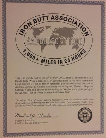
A short jaunt back to the main drag to get our final fuel receipts, closing out the ride at 22H 32M and 1,154 miles, the longest SaddleSore I've ridden to date both in terms of mileage and time. But the other SS1K rides I've been on have been primarily on the Slab so considering that this was about 95% secondary roads I was pleased with our overall time. We headed to the Best Western, got checked in and were very pleased to see our truly nice room that would rate 5 stars compared to the 1 star I'd give the Anasazi Inn, and the BW was $20 cheaper as well. A hot shower, some quick emails, and then to bed at 1 am, only to wake 4 hours later at 5 am, my normal “get-up” time. Not being able to get back to sleep, I grabbed my netbook, gps, logs, and headed downstairs for breakfast and paperwork duties, leaving Mike snoozing in his rack.
After he woke and had breakfast we loaded up and headed home. I rolled into the driveway at noon with 1,785 miles on the clock since leaving at 0830 on Friday morning, and 10 hours of sleep under my belt. All in all, a great ride for a great cause.
If you're curious about the silk scarf in my flag photos, here is a close up shot...

The man it belonged to is the third one on the right...

Another shot of him on his new 1952 H-D Hydra Glide...

Yes, that was my dad. Korea and Vietnam vet. He died when I was 15 so I never got a chance to ride with him. This was a way for me to do so.
Here is the SPOT tracker from Kayenta to Douglas...
Because Matt Hogan (AZ sponsor) is such a diabolical planner, I could not find a way to start in Phoenix without backtracking at least a couple hundred miles so the decision was made to ride to our starting point in Kayenta on Friday, and then begin the ride Saturday morning. Mike and I met at the Chevron at I-17 and Carefree Hwy and then began our way north. Winds were forecast to be strong but we didn't have much of a problem until we got onto 89 north of Flagstaff. With gusts up to 50 mph we spent most of the northern trek leaned to the left. Once we turned onto 160 and headed to the northeast the wind was to our back and not as much of a problem.
After checking in to our luxurious accommodations (snicker, snicker) at the Anasazi Inn – Tsegi Canyon we made our way in to Kayenta to have an early dinner and get our first photos at the Burger King. This is the site of the Navajo Code Talkers Memorial. While a fast food restaurant would not seem to be the best place for something like this, there was no shortage of visitors to the location while we were there. Not taking any chances, I took the required photo inside, one showing the hours sign indicating that they were closed at 11 pm (our ride was scheduled to begin at 1 am), and a couple of exterior shots to show that we rode there.
Then it was back to the "hotel" to get our Start Of Ride Witness form signed and for six hours of shuteye before the adventure began. The first glitch is that the Navajo Nation in the upper right corner of the state does not adhere to normal Arizona time, so the time on my alarm clock in the room was different from the Goldwing clock. Trying to plan ahead we set the alarm for 1 am the next morning since that would be midnight in the rest of the state. The alarm sounds, we get ready and packed and head into Kayenta for our starting fuel receipt. We both had a receipt start time of 1 am so how much more perfect could that be? But wait, didn't we just wake up at 1 am? So how could the receipt show 1 am when it took us an hour to get there? These questions did not make it through our sleep-muddled brains at that point, but it would come back to haunt us later in the day.
As we are fueling up in Kayenta, a passing motorist wished us Safe Travels and warned us about animals for the next 90 miles. He shook his head in mild disgust at the amount of critters he has seen on these roads at night. Just one more thing for us to be concerned about on this ride.
Although it was 105+ in the Phoenix area just the day before we are expecting some low temps on this ride so heated gear was part of tonight's routine:
Fuel receipt and mileage logged? Check!
Trunk and side bags closed and secured? Check!
Gerbing liner plugged in and on? Check!
Gerbing gloves on? Check!
SPOT on, secured, in Tracking mode? Check!
Headset plugged in and volume adjusted? Check!
Heated grips on? Check!
And then... off we rode. Our route... 160 west passing through Tuba City and then south on 89. Our speeds are low at first and then as I get more comfortable with the reach of my HIDs I open it up a little more. The first scare of the trip comes about half way to Tuba City as a single deer runs across the road in front of me. Knowing that deer tend to not be solitary animals I brake hard, but not hard enough to engage the ABS and my brake modulator flashes a warning to Mike, riding about a hundred yards behind me. He too brakes hard but the one deer was all we saw. Either this one was the tail end of the pack, or he/she was in fact alone. The scare was enough for me to clench my Alaska buttpad between my cheeks and fog up my face shield for a short while. But then soon enough the heart rate subsides and the speeds increase.
We eventually reach 89 and begin to head south past Cameron and the east entrance to the Grand Canyon. At 2:30 in the morning traffic is pretty light but we keep the speeds to no more than 4-9 miles over the limit for “most” of the ride. Any tickets we get on this trip will more than offset any gains in time we would have made by excessive speeds so we keep it reasonable. Nevertheless, the radar detector is in Highway mode and is searching for any stray signals. A new farkle installed the day prior is an LED box that blasts our six red lights instead of allowing the detector to chirp. At higher speeds the chirps are difficult to hear, but in the dead of night those LEDs lighting up will really get your attention in a hurry.
As we approach Flagstaff the altitude begins to increase and temps begin to decrease and I was really happy that I invested in that Gerbing gear last year. We saw a high elevation on this trip of over 7600 feet and soon after that we saw our low temperature of 30 degrees. After leaving Flagstaff and coming down the Rim we saw the temperature increase, but it never got much over 40 degrees. After three hours on the bike and 200+ miles under our wheels we rolled into Camp Verde for our first refueling. Both Mike and I were showing low fuel lights by that time. He was on a Concours 14 (1400 cc) and both that and the 1800 cc Wing are not known for being very fuel efficient at higher speeds.
After gassing up and off-loading some of our own fluids we saddled up and headed for Payson and our next memorial site located next door to the Zane Grey cabin. This memorial is dedicated to those Fire Fighters who battle Arizona's wildfires. We rode Hwy 260 from Camp Verde until it intersects 87 going south to Payson through Strawberry and Pine. This was the first time that I had ridden this section of 260 and it's a great motorcycle road to ride, especially right at sunrise. And what happens at sunrise? Well, the critters start getting active and it becomes time for our next encounters with Arizona wildlife. The first one was a jackrabbit shortly after getting into the twistie portion of 260, and then shortly before reaching the 87 intersection I crested a rise to see two elk standing in the road ahead of me and once again I was hard on the brakes, but they had seen me coming and hustled off the road before I even got close. Knowing that elk, like deer, are pack animals I kept the speeds down again for a while before wicking it back up. We were soon passing through Strawberry and I was lamenting the fact that it was so early in the day and I'd be unable to get a slice of strawberry pie at the Strawberry Lodge. The next town was Pine and everything there was quiet as well and as we reached the Rimside Grill and the speeds increased I was startled to see anywhere from six to a dozen elk on the side of the road, just eating, laying down, and watching the traffic go by.
Down the hill we go into Payson to get our requisite photos and then turn our attention to Phoenix.
We were concerned that the high winds the prior day may have increased the risk to closing 87 (The Beeline) into Phoenix due to the Sunflower Fire, but other than some smoke in the air we were unhampered. It was about 7:00 by the time we reached Phoenix and traffic was starting to pick up. We made our way downtown and to the Wesley Bolin Plaza to get our photo at the anchor from the USS Arizona.
It was fitting that on this day they were prepping the grounds for the annual Fallen Officers event that honors those who have given all to protect the rest of us. Unfortunately we could not wait several hours for this event to start and we needed to get back on the bikes. As we were leaving downtown we were stopped by a passing train so instead of waiting we made a right turn and headed north so that we could grab another westbound cross street to take us to I-17 north. When we reached Grand Ave we sat in the turn lane and then realized it wasn't working, so we moved to a regular lane so we could go through the intersection and then make a u-turn from there. We both realized that if we had just waited for the train to pass we would have not been as far behind on time.
Reaching I-17 we turned north with the intention of heading to Wickenburg. The GPS wanted to route us up Grand Ave (Hwy 60) but I felt that our route may be longer but faster due to not having multiple stop lights along the way. We gassed up at the Chevron at I-17 and Carefree Hwy, the same spot we had left from 22 hours previously, and then started toward Wickenburg. We both had a craving for an Egg McMuffin when we reached the Micky D's in Wickenburg, but our hopes were dashed as we rounded the corner only to see fencing all around the restaurant and a sign out front stating Closed For Remodel. Not wanting to spend time hunting down another breakfast place in town we turned north on 93 with Kingman in our sights. Remembering that the gas station at Vulture Mine Road also had a fast food restaurant, we pulled in and saw that it was a Jack In The Box. Well, a Breakfast Jack is not as good as a McMuffin, but when you've been up for 8 hours and you're hungry, anything will do. Fast food it was not, as it appeared that they were short on staff. Attractive food it was not, especially compared to the photo on the wall, but it disappeared into my belly before my eyes had a chance to object.
With breakfast over we clambered back on our bikes and started to make our way to Kingman and the Doxol Disaster Memorial dedicated to those who died in this tragic event in 1973.
When we arrived at the park we were pleased to see that the community was putting on a classic/muscle car show. We were a couple of minutes ahead of schedule so we looked at a few sharp cars and Mike took some photos. On the way out we fueled up at Circle K and then headed west to our next stop... Oatman. We had now been on the road for 10.5 hours and had covered 573 miles, more than half of what we needed to get our SaddleSore certification, but we still had three more sites to get to and a lot more miles to ride.
It was a really rough road going into Oatman with many 10 – 20 mph hairpins, no guardrails, and a very narrow roadway. Once we did reach the town, traffic came to a dead stop due to a gunfight re-enactment taking place and all the tourists were in the street. In addition, the famous burros of Oatman were wandering around looking for handouts. Finally we were able to get through town head for our next memorial dedicated to Korean War vets. This is either quite a walk or quite a ride down a dirt/gravel road. We chose to ride. I don't know what the elevation was, but the short climb from the road to the memorial had me out of breath. And it was HOT too. Photos were taken and then we had to get the bikes turned around on the narrow path and get back to the main road. From there it was a great twistie ride down to I-40 for another short run on the slab eastbound to 95 south.
We stopped at the Love's truck stop to cool off for a bit (store clerk said it was 105) and chow down on some jerky. I had the pleasure of having a guy come up to me and ask who the Patriot Guard Rider was. I acknowledged that it was me and he told me how much he appreciated what we do. When I asked if he was a vet he said he was and had just returned from Kuwait. I told him that what we do is for and because of people such as himself and thanked him for his service. It was a nice moment and it would not have happened if I wasn't doing the TOH ride.
Too soon it was time to gear up and head south to fuel up in Quartzsite and then continue on to the next memorial site in Yuma. The temperature showing on my bike was 102 – 100 the remainder of this portion. It was even worse after leaving Quartzsite and we were stopped due to road contruction. Fortunately the lady in front of us allowed us to hide in the shade of her camper van while we waited for the Pilot Vehicle to show up and take us several miles down the road. Free at last we Let Loose The Dogs of Horsepower and blazed our way to Yuma. My drenched LD Comfort undergear had been soaked at the last fuel stop and the evaporative cooling effect was in full force. 100 degrees outside and probably 80 degrees inside my textile jacket. With my Butler Cup on the handlebar providing ice water I was as comfy as could be expected.
Upon reaching Yuma we had to travel westbound for about 10 miles, our only “sun in our face” ride for the entire trip. We soon reached the site, got our photos and headed east to the closest Love's to fuel up ourselves and the bikes.
It was at this point that we began to wonder if we were going to make Douglas within our 24 hour limit. There were conflicts between Mike's GPS and mine in terms of elapsed time and time to destination and it appeared that we were going to be cutting it pretty close. We had nothing but slab in front of us from Yuma to Benson, and much of that was at a posted 75 mph limit. Once we got past the Border Patrol checkpoint we were able to ratchet it up to a higher level than the previously stated speeds and we were soon making very good time. The unintended consequences of this is that the Wing started gulping fuel like a rugby fan quaffing suds at a championship match. I had to catch up to Mike near Casa Grande and let him know I needed fuel as my low fuel light had been on for several miles. We lowered our speeds and once again rolled into yet another Love's truck stop, this one near the I-8 / I-10 junction.
Along the way to this point I had been giving some thought to our times. My GPS showed that we had a cushion of about two hours if the 1 am starting receipt was a legit time, and even if I was wrong we still had a one hour cushion. After getting our receipts and logging our mileage we decided to make one more fuel stop in Benson for a “splash and go” before turning south to Douglas. When we reached Benson there were numerous detours due to the current construction on I-10 and we got off the freeway one exit too soon, but it took us to a Shell station where did our final fueling before hitting the road for the last time.
From Benson we traveled through St David, then down through Tombstone, climbing the mountainss and rolling through the tunnel took us into Bisbee, a quick battery change on Mike's SPOT, down past the old open pit copper mine, a ¾ trip around the roundabout and then on to Douglas. With very little traffic on the road all we really had to worry about was the constant warning signs stating “Watch For Animals” every few miles. As we ride down the other side of the mountains the lights of Douglas come into view and we know we only have a few more miles to ride and plenty of time to get there. As we roll into town we hang a right onto the Pan American Highway (191) and then into the Police Department parking lot to get our final photo at the Fallen Officers Memorial. As it was 2330 and the Memorial was not lit, we aimed the bike headlights in the general direction and took our photos, hoping for the best.
A short jaunt back to the main drag to get our final fuel receipts, closing out the ride at 22H 32M and 1,154 miles, the longest SaddleSore I've ridden to date both in terms of mileage and time. But the other SS1K rides I've been on have been primarily on the Slab so considering that this was about 95% secondary roads I was pleased with our overall time. We headed to the Best Western, got checked in and were very pleased to see our truly nice room that would rate 5 stars compared to the 1 star I'd give the Anasazi Inn, and the BW was $20 cheaper as well. A hot shower, some quick emails, and then to bed at 1 am, only to wake 4 hours later at 5 am, my normal “get-up” time. Not being able to get back to sleep, I grabbed my netbook, gps, logs, and headed downstairs for breakfast and paperwork duties, leaving Mike snoozing in his rack.
After he woke and had breakfast we loaded up and headed home. I rolled into the driveway at noon with 1,785 miles on the clock since leaving at 0830 on Friday morning, and 10 hours of sleep under my belt. All in all, a great ride for a great cause.
If you're curious about the silk scarf in my flag photos, here is a close up shot...
The man it belonged to is the third one on the right...
Another shot of him on his new 1952 H-D Hydra Glide...
Yes, that was my dad. Korea and Vietnam vet. He died when I was 15 so I never got a chance to ride with him. This was a way for me to do so.
")