• Welcome to the Two Wheeled Texans community! Feel free to hang out and lurk as long as you like. However, we would like to encourage you to register so that you can join the community and use the numerous features on the site. After registering, don't forget to post up an introduction!

Willow Springs Bridge

Joined
Sep 29, 2006
Messages
40
Reaction score
0
Location
Houston, Texas
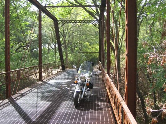
There is a unique single lane steel grate bridge (about 50-70 feet in length) on Willow Springs road about 5 miles northeast of Fayetteville off of Highway 159. There is another single lane bridge (similar but not navigable) just west of there on an adjacent road. If you go onto the bridge, note the steel sign on the right with initials and date. That was put there by local residents in honor of an old gentleman who fished there for many years and had his ashes dumped into Willow Creek from the bridge. If you contine northeast on the road, it soon turns to gravel for a few miles (easily ridden by heavy touring bikes and cruisers as well) and will bring you out onto Highway 954. The bridge was originally a wooden bridge, but was set on fire by local teenagers, and a steel grate bridge was built in its place.
 
Walturd, you mean this one???
 

Attachments

  • IMG_0029 (Small).JPG
    IMG_0029 (Small).JPG
    96.9 KB · Views: 477
  • IMG_0031 (Small).JPG
    IMG_0031 (Small).JPG
    86.9 KB · Views: 471
Would one of ya'll be kind enough to post a link to this bridge on a map or provide coordinates for it? I'm looking on the map along Willow Spring Road and not sure where this bridge is.

Thanks!
 
From the juction of Hwy 109 and 159 in Industry, go west on 159 about 6.3 miles---the road will be on your right. Approximate GPS coordinates are: N29 57.087 and W96 37.762----have fun.
 
From the juction of Hwy 109 and 159 in Industry, go west on 159 about 6.3 miles---the road will be on your right. Approximate GPS coordinates are: N29 57.087 and W96 37.762----have fun.

Thanks -found the road. How far up Willow Springs Road from 159 is it to the bridge?
 
First, the Mapsource coordinates are: N29 57.109
W96 37.735.....the hard top road (again, to the right and it sneaks up on you but there is a sign) goes for about 250-300 yards, then you are at the foot of the bridge. It is hard top after you cross the bridge, but not far...it becomes a gravel road that even Goldwings and Ultraclassics can easily maneuver which eventually takes you to
Hwy 954. When you get on the bridge and look down at that water, you'll wish you had brought a fishing pole and some worms. If you walk along the side of the creek, watch for snakes.
 
I know that I edited the message to include more info, but I'll try again with a separate message...getting close to my beddy bye time. The Mapsource map coordinates for the road junction are N29 57.109 W96 37.735. The hard top road is about 200-250 yards to the foot of the bridge, and the hard top road on the other side of the bridge is short and turns to gravel that is manageable by Goldwings and Ultraclassics for a few miles to Hwy 954...a nice ride overall. About .7 mile further down Hwy 159, also to the right, is Coufal Road...down that road a few hundred yards you'll find another single lane bridge to the right of the main road---it was abandoned long ago and isn't fit to walk on. If you continue on down Coufal Road, you'll almost hear duelling banjoes playing.

Come back to this topic on this forum and let me know if you found the second bridge..it is hidden in the bushes and grass....then I'll tell you about the Brazos River Ferry Road...
 
Many thanks. I will try to make time to check out the first bridge during the pie run later this month. As I will have several people following me, I wanted to know where it is before I head out.
 
Line them up and take pictures on the bridge. My old buddy (on his white Goldwing) was afraid of steel grate bridges until I convinced him to go up and let me get a picture...well, he finally did, and I put the camera on a fence and got a picture of both of us up there....he is no longer afraid of steel grate bridges---and we rode the gravel road and he now realizes that he CAN handle some gravel roads. His wife framed the picture.
 
Thanks for the update, walturd. My group will have one HD and several lighter bikes - all strictly street. Last year, I inadvertently took a group (many of the same guys) down a 6 mile stretch of rough gravel. They may lynch me as we head down this one, but I'll do my best to convince them it's worth the risk :-)
 
wife and i made it over this bridge last weekend. the road coming from the north was abit rough for her vtx and my goldwing but no problems. She asked me "How in the **** did you find THIS place?" told her on this site.
i hope to visit more bridges soon like this one. Make sure when posting about them tho that you mention WHERE they are.
no fun just looking at the pictures.
michael
 
Tex Gov has a website of weak bridges all over the state , A good place to find interesting old bridges . SEYA
 
in regards to the one on Coufal rd. It takes off of 159, turns right then how far for the bridge? I am trying to find it on the maps satalite. i only see one area that has a possible creek that runs under the road. is that where it would be? looks like a couple drain pipes are now in service. would it just be to the right of there?
Michael

the bridge is on the road before you reach Coufal, it is on willow springs road.
 
in regards to the one on Coufal rd. It takes off of 159, turns right then how far for the bridge? I am trying to find it on the maps satalite. i only see one area that has a possible creek that runs under the road. is that where it would be? looks like a couple drain pipes are now in service. would it just be to the right of there?
Michael
These are the 2 bridges in the area. The 1st one is on Haw Creek Road. Take Coufal (pronounced soo fall) off 159, it will 'T' into Haw Creek, turn right on Haw Creek and go maybe a mile till you get to the new concrete bridge, look to the right and you'll see the old bridge.

https://www.google.com/maps/@29.9797226,-96.6567383,94m/data=!3m1!1e3

This is the Willow Springs bridge. Take Willow Springs off 159, you can't miss it.

https://www.google.com/maps/@29.9546104,-96.6336072,95m/data=!3m1!1e3

You can get to both bridges from 954 as well.
 
I remember riding over it a bunch growing up as we lived not far from it in the old Fordtran home just north on Marek road on Fordtran road
 
I've been on most of those roads in that area , one thing I would wager a buck on is its on private property .
 
Back
Top