


 Feel free to hang out and lurk as long as you like. However, we would like to encourage you to
 - Joined
- Oct 16, 2008
- Messages
- 3,611
- Reaction score
- 4,375
- Location
- Bryan, TX
- First Name
- Dennie
- Last Name
- Spears
A ride report about friendship, joy, sadness, beauty and devastation over a 2 week period.
I announced to my 5 primary riding buddies: I'm going to southern Utah, northern Arizona and a little bit of New Mexico and Colorado. I'd like to go for 2 weeks, but we can just go to Utah if everyone wants to go for just a week. We'll be camping. Mostly free camping in the forest or on BLM land. Cost will be around $350 to $400 each for 2 weeks. When, they asked? Leaving May 12th would allow all but one to go. Other dates excluded more people so we kicked Jeff out and started planning. Jeff is the starter for CMRA, the promoter for TMGP, father to six children and the father of a young man getting married in June and the family is moving to a new house. He doesn't have time for breakfast, much less a 2 week trip. Bobby Palmer hears about it way over in Georgia and wants to go. Back up to 6. Further discussion ensues. Questions presented by my 5 riding buddies: Why don't we rent a house for a week like we did last year in N Carolina? OK, the price is now $600 each. Why don't we rent 2 houses for a week each and just do loop rides? OK, the price is now $800, assuming we can find houses only a month before departure. Why don't we just go to Ouray and stay there for 2 weeks? STOP, back to the original plan. Who wants to go? Three decide to go for 2 weeks and three decide to go to Ouray for 1 week. We'll meet in Moab for a couple of days riding around Canyonlands, Arches and Colorado National Monument.
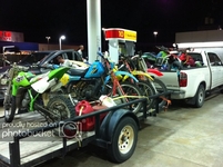
The 2 week group trailered to my brother's house in Taos, NM, and got there just before 11:00 on Saturday morning after driving overnight from Byan. The 1 week group would trailer to Ouray a week later.
We have created a tradition of having our waitress sit on my lap after our first breakfast on the road. It’s getting harder as I get uglier.

This mural was in the parking lot of our breakfast restaurant in Las Vegas, NM

We were in a hurry to get to Gallup, NM where we were going to spend the night and with 350 mile to go, we didn’t stop very much along the High Road to Taos. I had been there many times before. Also, we bypassed Los Alamos because highway 4 around town is so nice and the town doesn’t allow firearms, even on the main highway through town.
Along highway 4. This is a volcano crater, Valle Caldera. It’s been a while since it’s erupted. Now a National Preserve.

Maurice and Ray about to be obliterated if the thing blows.
 [/url]
Someone took the time to pound a lot of nail in an interesting pattern.

This interesting rock formation was deposited by the water rather than worn by the water like most waterfalls. High Sulphur content also. Jemez Hot Springs is nearby.

The old railroad bed, worth the short ride off of highway 4.

One of 2 tunnels that they blasted through rock.

Popular with rock climbers. I’ve been here twice and saw climbers both times.

We spent the night in a motel in Gallup NM. A lot of day 1 was spent just riding to get out of my birth state.
Day 2
On to Arizona. This is Window Rock, a formation that gives the city of
Window Rock its name. Window Rock is the capital of the sovereign Navaho Nation.
 [/url]
…and home to a monument to the wind talkers of WWII.


Along the highway to Canyon de Chelly National Monument, but it could be just about any road in northern Arizona or southern Utah.

Our first turn out at Canyon de Chelly. Ray said, “I thought it would be bigger.” He had mistakenly thought we were going to the Grand Canyon first.
Living on the edge.

Cacti were just starting to bloom.

There is a herd of about 20 horses to the right of the slight bend in the river just after it emerges from the trees.

The road north out of Chinle Arizona was closed so we used an alternate route that took us on 20+ miles of dirt road. We got behind schedule and decided to stay in Page. The local campground had a vacancy. We should have driven down and looked at it before we paid. Our campsite was separated from a four lane highway by one other campsite full of youngsters with lots of beer and a radio. There was also a stray kitten that wandered close to our tents several times during the night. Its constant meowing was only drowned out by the occasional 18 wheeler passing. Ray tried to catch it. I'm not sure whether he wanted to comfort it or kill it in a sleep deprived rage.
Day 3
Horseshoe bend, a very popular site just outside of Page Arizona. It’s a short hike over rocky trails with some deep sand, but well worth the walk to look over the edge. And, it’s free. If you happen to ever fall over the cliff, grab my hat off the bush on your way down. Wind was high.

We saw this rig when we got back to the parking lot for Horseshoe bend. Hydraulic lift!

Mandatory stop at the Navajo Bridges.

We saw this fellow at the bridges. He said he wasn’t actually a rider.

We got to the north rim of the Grand Canyon on May 15th, opening day. The N rim is much higher than the S rim and is snowed in most of the winter. There must have been a glitch because when we arrived around 10:00 the line wasn't moving except when someone got tired of waiting and did a U-turn. Looking forward.

Looking back.

We did meet this lady traveling alone from around the Austin area. She's camping all the way. Soozie is now my co-hero, along with this lady.

Of course, the wait was worth it.


Ray close to the edge. I'm beginning to think Maurice is afraid of sudden stops at the bottom of canyons.

Me, back in my hippie days.

Maurice does get close to the edge, sortta.

Leaving GCNP.

Beautiful slot canyon coming up. Couple hundred feet deep and Maurice touched both sides at the same time with his shoulders.
I announced to my 5 primary riding buddies: I'm going to southern Utah, northern Arizona and a little bit of New Mexico and Colorado. I'd like to go for 2 weeks, but we can just go to Utah if everyone wants to go for just a week. We'll be camping. Mostly free camping in the forest or on BLM land. Cost will be around $350 to $400 each for 2 weeks. When, they asked? Leaving May 12th would allow all but one to go. Other dates excluded more people so we kicked Jeff out and started planning. Jeff is the starter for CMRA, the promoter for TMGP, father to six children and the father of a young man getting married in June and the family is moving to a new house. He doesn't have time for breakfast, much less a 2 week trip. Bobby Palmer hears about it way over in Georgia and wants to go. Back up to 6. Further discussion ensues. Questions presented by my 5 riding buddies: Why don't we rent a house for a week like we did last year in N Carolina? OK, the price is now $600 each. Why don't we rent 2 houses for a week each and just do loop rides? OK, the price is now $800, assuming we can find houses only a month before departure. Why don't we just go to Ouray and stay there for 2 weeks? STOP, back to the original plan. Who wants to go? Three decide to go for 2 weeks and three decide to go to Ouray for 1 week. We'll meet in Moab for a couple of days riding around Canyonlands, Arches and Colorado National Monument.
The 2 week group trailered to my brother's house in Taos, NM, and got there just before 11:00 on Saturday morning after driving overnight from Byan. The 1 week group would trailer to Ouray a week later.
We have created a tradition of having our waitress sit on my lap after our first breakfast on the road. It’s getting harder as I get uglier.
This mural was in the parking lot of our breakfast restaurant in Las Vegas, NM
We were in a hurry to get to Gallup, NM where we were going to spend the night and with 350 mile to go, we didn’t stop very much along the High Road to Taos. I had been there many times before. Also, we bypassed Los Alamos because highway 4 around town is so nice and the town doesn’t allow firearms, even on the main highway through town.
Along highway 4. This is a volcano crater, Valle Caldera. It’s been a while since it’s erupted. Now a National Preserve.
Maurice and Ray about to be obliterated if the thing blows.
Someone took the time to pound a lot of nail in an interesting pattern.
This interesting rock formation was deposited by the water rather than worn by the water like most waterfalls. High Sulphur content also. Jemez Hot Springs is nearby.
The old railroad bed, worth the short ride off of highway 4.
One of 2 tunnels that they blasted through rock.
Popular with rock climbers. I’ve been here twice and saw climbers both times.
We spent the night in a motel in Gallup NM. A lot of day 1 was spent just riding to get out of my birth state.
Day 2
On to Arizona. This is Window Rock, a formation that gives the city of
Window Rock its name. Window Rock is the capital of the sovereign Navaho Nation.
…and home to a monument to the wind talkers of WWII.
Along the highway to Canyon de Chelly National Monument, but it could be just about any road in northern Arizona or southern Utah.
Our first turn out at Canyon de Chelly. Ray said, “I thought it would be bigger.” He had mistakenly thought we were going to the Grand Canyon first.
Living on the edge.
Cacti were just starting to bloom.
There is a herd of about 20 horses to the right of the slight bend in the river just after it emerges from the trees.
The road north out of Chinle Arizona was closed so we used an alternate route that took us on 20+ miles of dirt road. We got behind schedule and decided to stay in Page. The local campground had a vacancy. We should have driven down and looked at it before we paid. Our campsite was separated from a four lane highway by one other campsite full of youngsters with lots of beer and a radio. There was also a stray kitten that wandered close to our tents several times during the night. Its constant meowing was only drowned out by the occasional 18 wheeler passing. Ray tried to catch it. I'm not sure whether he wanted to comfort it or kill it in a sleep deprived rage.
Day 3
Horseshoe bend, a very popular site just outside of Page Arizona. It’s a short hike over rocky trails with some deep sand, but well worth the walk to look over the edge. And, it’s free. If you happen to ever fall over the cliff, grab my hat off the bush on your way down. Wind was high.
We saw this rig when we got back to the parking lot for Horseshoe bend. Hydraulic lift!
Mandatory stop at the Navajo Bridges.
We saw this fellow at the bridges. He said he wasn’t actually a rider.
We got to the north rim of the Grand Canyon on May 15th, opening day. The N rim is much higher than the S rim and is snowed in most of the winter. There must have been a glitch because when we arrived around 10:00 the line wasn't moving except when someone got tired of waiting and did a U-turn. Looking forward.
Looking back.
We did meet this lady traveling alone from around the Austin area. She's camping all the way. Soozie is now my co-hero, along with this lady.
Of course, the wait was worth it.
Ray close to the edge. I'm beginning to think Maurice is afraid of sudden stops at the bottom of canyons.
Me, back in my hippie days.
Maurice does get close to the edge, sortta.
Leaving GCNP.
Beautiful slot canyon coming up. Couple hundred feet deep and Maurice touched both sides at the same time with his shoulders.

