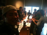
Voni has them all over Facebook. Looks fantastic.


-
 Welcome to the Two Wheeled Texans community!
  Feel free to hang out and lurk as long as you like. However, we would like to encourage you to register so that you can join the community and use the numerous features on the site. After registering, don't forget to post up an introduction!
You are using an out of date browser. It may not display this or other websites correctly.
You should upgrade or use an alternative browser.
You should upgrade or use an alternative browser.
Stories from Occupied New Mexico
- Thread starter TexasShadow
- Start date
Just came in from 2-hr walkabout. Sipping hot coffee and downloading photos now.I was hoping for some snow pictures.
- Joined
- May 20, 2004
- Messages
- 12,838
- Reaction score
- 661
- Location
- Austin, TX
- First Name
- Rusty
- Last Name
- Myers
Just came in from 2-hr walkabout. Sipping hot coffee and downloading photos now.
Great, look forward to seeing them. Sorry we missed you out there earlier in the week. Had a brief conversation with Ed and just figured we'd run into you too, but ended up heading home a day early to miss the rain and wind.
DaveC
0
- Joined
- Sep 29, 2004
- Messages
- 10,191
- Reaction score
- 111
- Location
- On the fringe of the Hippoplex
- First Name
- David
- Last Name
- Carter

Snow in Occupied New Mexico, P2
Spent most of the day outside. Of course. Still damp and cold.
It was barely sunrise. I'm the only human moving around outside. Up on top of the hill I went. Strolled around for nearly 2 hous; taking shots, gazing around, watching the human world wake and crawl around in the snow, smiling at the pair of crows with whom I usually have morning conversations.
Caught site of the top of Tule Mnt. It was the only mountain in the National Park I would see all day. Chisos (and Christmas Mnts) remained curtained in clouds. Most of the plant life was mostly enveloped with snow.


I was on a mesa at the base of Maverick Mnt. Which affords a vista west towards the Ghost Town, Reed Plateau, Rough Run Draw, and overlooks a section of Hwy 118. North is Study Butte with Willow and Bee Mnts beyond.

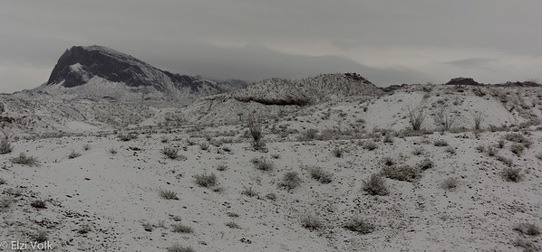


And nearby is the Study Butte Cemetery


Later, went to El Punto, where there was about 4 inches of snow, still cold. Went for a hike anyway. Followed coyote tracks, no javalina tracks, and are these rabbit or rat?


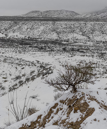
As I was framing a shot of a lechuguilla flower (odd time of year for it to flower), a hummingbird flew into the frame just as I opened the aperture. It was off as fast as it flew in. It sounded like a giant heavy mosquito.

South County road was............. a mess. Reminded me of mud season in Maine, except this is slick as snot. Melting snow is worse than a rain in silty sand. We slid here and there, and side to side. In 4-wheel drive. After a big storm in Maine, I just waited for the roads to be plowed, which sometimes took a day or more. No problem; go ski, snowshoe, read, knit socks, make snow angels. It's all good.
I plan to adopt the same when I am permanently living off pavement. Go for hike, read, knit scarf, take nap, write, talk to the coyotes, sit and chat with the Grandfather rocks. They can tell many stories.
When you visit here, you see the surface of these mountains, arroyos, and mesas. But you don't get to know them, learn their stories, until you spend time with them. They welcome you, teach you lessons (like when I got lost for 4 hours last week), and you become acquainted with other life that share these places. Before long, these mountains, arroyos and mesas are part of you, the you are part of them.
In cities and suburbs, you have your house, car, employment, and stores. They are all man-made, constructed from things that are dug out, cut off, and pulled up out of and off the landscapes that I, we, and all the other life that surrounds us....... call 'home'. Not just a box for shelter, not just a box of metal that propels you forward, not just dead lime and gravel that people drive and walk on, live and sleep in. Not just the old dead hearts of trees that are stitched together now like band-aids that make up modern houses.
The sand, gravel, rock and clay here is what provides many of us, human and non-human, with our homes. Formed and melded together by water and sun, fire and pressure, adobe and rock are my 'birthstones.' And so we listen, watch, learn and respect the Grandfather rocks, the mud, the water, sun, and all the rest of life that survives out here.
There is a reason that desert people, and all desert life, are survivors.
Even in snow.
Spent most of the day outside. Of course. Still damp and cold.
Got up. Got outa bed. Said heck with the comb across my head.
Bundled up and went outside,
Birds chirped and I went into a dream.
Of snow.

Bundled up and went outside,
Birds chirped and I went into a dream.
Of snow.
It was barely sunrise. I'm the only human moving around outside. Up on top of the hill I went. Strolled around for nearly 2 hous; taking shots, gazing around, watching the human world wake and crawl around in the snow, smiling at the pair of crows with whom I usually have morning conversations.
Caught site of the top of Tule Mnt. It was the only mountain in the National Park I would see all day. Chisos (and Christmas Mnts) remained curtained in clouds. Most of the plant life was mostly enveloped with snow.
I was on a mesa at the base of Maverick Mnt. Which affords a vista west towards the Ghost Town, Reed Plateau, Rough Run Draw, and overlooks a section of Hwy 118. North is Study Butte with Willow and Bee Mnts beyond.
And nearby is the Study Butte Cemetery
Later, went to El Punto, where there was about 4 inches of snow, still cold. Went for a hike anyway. Followed coyote tracks, no javalina tracks, and are these rabbit or rat?
As I was framing a shot of a lechuguilla flower (odd time of year for it to flower), a hummingbird flew into the frame just as I opened the aperture. It was off as fast as it flew in. It sounded like a giant heavy mosquito.
South County road was............. a mess. Reminded me of mud season in Maine, except this is slick as snot. Melting snow is worse than a rain in silty sand. We slid here and there, and side to side. In 4-wheel drive. After a big storm in Maine, I just waited for the roads to be plowed, which sometimes took a day or more. No problem; go ski, snowshoe, read, knit socks, make snow angels. It's all good.
I plan to adopt the same when I am permanently living off pavement. Go for hike, read, knit scarf, take nap, write, talk to the coyotes, sit and chat with the Grandfather rocks. They can tell many stories.
When you visit here, you see the surface of these mountains, arroyos, and mesas. But you don't get to know them, learn their stories, until you spend time with them. They welcome you, teach you lessons (like when I got lost for 4 hours last week), and you become acquainted with other life that share these places. Before long, these mountains, arroyos and mesas are part of you, the you are part of them.
In cities and suburbs, you have your house, car, employment, and stores. They are all man-made, constructed from things that are dug out, cut off, and pulled up out of and off the landscapes that I, we, and all the other life that surrounds us....... call 'home'. Not just a box for shelter, not just a box of metal that propels you forward, not just dead lime and gravel that people drive and walk on, live and sleep in. Not just the old dead hearts of trees that are stitched together now like band-aids that make up modern houses.
The sand, gravel, rock and clay here is what provides many of us, human and non-human, with our homes. Formed and melded together by water and sun, fire and pressure, adobe and rock are my 'birthstones.' And so we listen, watch, learn and respect the Grandfather rocks, the mud, the water, sun, and all the rest of life that survives out here.
There is a reason that desert people, and all desert life, are survivors.
Even in snow.
- Joined
- Feb 28, 2003
- Messages
- 51,246
- Reaction score
- 8,254
- Location
- Huntsville
- First Name
- Scott
- Last Name
- Friday
The Merry Christmas shot is fantastic 
DaveC
0
- Joined
- Sep 29, 2004
- Messages
- 10,191
- Reaction score
- 111
- Location
- On the fringe of the Hippoplex
- First Name
- David
- Last Name
- Carter
I was thinking this shot was fantastic! Just great , thanks.

Just read this thread from start to finish.
I first and last visited Big Bend just before I and my wife of 30 years had our first child. He is a Junior in college today.
I had already announced that we need to "Adventure" in Big Bend as soon as the weather starts to turn nice. (March?) With all the kids now out of the nest, and with our recent motorcycle trip across parts of Australia, (last May) we have discovered a new chapter in our life where a loaded down Tenere is our preferred method of travel.
We are sure to enjoy Big Bend much more now.
Thanks for taking the time and effort that must have been required to document these moments and observations.
Cheers
Bruce
Last edited:
Why, thanks, Bruce! Feel free to contact me when you decide to come down. I'd be happy to show you around!We are sure to enjoy Big Bend much more now.
Thanks for taking the time and effort that must have been required to document these moments and observations.
Cheers
Bruce
Good Morning, Sir Sky Island

The Chisos Mnts are unique in many ways. It is the only place I know where one can see the sun set twice, east and west. As the sun begins to reach the west horizon, it reflects on the western slopes of the Chisos Mnts. and the myriad of smaller mountains, uplifts, mesas, and plateaus. Mostly, these landforms are lit with a muted rosy glow.
Occasionally, like last night with an alley of light in the west, the light is still clear and bright, illuminating these landforms like a giant spotlight. If one sits on the Front Porch at the Ghost Town, you can watch this light creep up and up the slopes of all the mountains between the town and the peaks of the Chisos Mnts. All the striations of the uplifts, the flat-topped molars like Tule Mnt, and the western slopes of the sky island are just breathtaking.
And I didn't have my camera on me.
Then, the show is culminated with the colors of the sun setting in the west over the ridge.
Where I am now, I can see the sun in the morning as it creeps over the Chisos Mnts, the Sky Island, in all its glory. A short walk up the hill in my pajamas and jacket, and I'm on top of the world.


Where else can one see the sun rise and sun set on a mountain range?
The Chisos Mnts are unique in many ways. It is the only place I know where one can see the sun set twice, east and west. As the sun begins to reach the west horizon, it reflects on the western slopes of the Chisos Mnts. and the myriad of smaller mountains, uplifts, mesas, and plateaus. Mostly, these landforms are lit with a muted rosy glow.
Occasionally, like last night with an alley of light in the west, the light is still clear and bright, illuminating these landforms like a giant spotlight. If one sits on the Front Porch at the Ghost Town, you can watch this light creep up and up the slopes of all the mountains between the town and the peaks of the Chisos Mnts. All the striations of the uplifts, the flat-topped molars like Tule Mnt, and the western slopes of the sky island are just breathtaking.
And I didn't have my camera on me.
Then, the show is culminated with the colors of the sun setting in the west over the ridge.
Where I am now, I can see the sun in the morning as it creeps over the Chisos Mnts, the Sky Island, in all its glory. A short walk up the hill in my pajamas and jacket, and I'm on top of the world.
Where else can one see the sun rise and sun set on a mountain range?
DaveC
0
- Joined
- Sep 29, 2004
- Messages
- 10,191
- Reaction score
- 111
- Location
- On the fringe of the Hippoplex
- First Name
- David
- Last Name
- Carter
What is the name of the twin peaks just center right. Mule Ear?

Correct. The two landforms resembling ears of a mule are aptly named.What is the name of the twin peaks just center right. Mule Ear?

These two spikes are 'dikes,' magma that solidified inside volcanic ash. Over time, the exterior soft rock eroded and eventually exposed the black hard igneous rock which appears like a twin pillars, or 'ears.'
I haven't hiked the trail to the base of these dikes, but I hear it is well worth it. The trail ends at a 'cottonwood oasis', and I understand there is a spring nearby. It's on my list.
Contemplatin' Day
It was a Contemplatin' Day today. Sunshine, warmth, good friends, books and, well, contemplating.


It was a Contemplatin' Day today. Sunshine, warmth, good friends, books and, well, contemplating.
DaveC
0
- Joined
- Sep 29, 2004
- Messages
- 10,191
- Reaction score
- 111
- Location
- On the fringe of the Hippoplex
- First Name
- David
- Last Name
- Carter
Sure like that yard, looks like about mid morning by the shadows, I am presuming that the clouds are in the North as the front is coming in this evening here in Hutto.
Nope.Sure like that yard, looks like about mid morning by the shadows, I am presuming that the clouds are in the North as the front is coming in this evening here in Hutto.
")
The views in the photos above are to the SE (the southern section of BBNP and Santa Elena Canyon) and one photo with a view to the southern edge of Reed Plateau (so that would be ESE). There was a line of clouds hanging over Mexico most of the day, but clear as a bell over us!
Right now the wind is howling, the travel trailer is rocking and some stars are still beaming above; seems some clouds are moving in now.
Sky Island Oasis


Many canyons lay hidden within the sky island that is the Chisos Mountains. Streaking the slopes in and out of the Basin, these canyons vary from narrow winding slots to wide gulleys with towering cliffs. Because most of the steep canyons are inaccessible, except for experienced canyoneers, some of these canyons may have had barely a dozen human footprints in all their history. Others are visited more frequently because of developed and primitive trails traversing them, such as those on the Window Trail in the Basin.
One canyon scraped along the western slope of the Chisos group is Cattail Canyon. Only those people with experience in canyon climbing and with rock climbing gear can traverse most of the canyon, for it winds along and down with slots and loose screed. As with most canyons, water is an integral part of its formation and continued geological change. The entire length is dotted with pour-offs, water falls and tinajas.
Some sources, including an older topo map, claim that water runs year-round down this canyon. But, of course, that claim can't be static or accepted without consideration of the local climatic conditions. After all, historical records testify that 50 years ago the Rio del Norte and Terlingua Creek had running water (and plenty of fish) year round. But, despite our own mortal timelines, the climate is changing and the aridity of the Chihuahuan Desert increases and expands its boundaries northward.
Referring to a topo map, you will find Cattail Canyon between Ward Mnt and the ridge west of Oak Canyon, almost N-S along the western slope of the Chisos Mnts. The canyon runs about 5-6K feet in elevation and ends with a pour-off at the northern-most bend west at ~4,200 feet.
This pour-off, the only portion of Cattail Canyon easily accessible, is Cattail Falls (despite that many waterfalls are part and parcel of this canyon). However, you won't find the trail on any maps and in any guides, except on an old topo map. Because the waterfalls and tinajas are fragile ecosystems, the park attempts to reduce human traffic and consequent environmental damage often associated with heavy use. Their methods for reducing human visitation to sensitive areas are by physically prohibiting access or by removing references to these area from guides and maps. However, some signage remains with limited directions for the trail, and the trail is maintained in primitive condition.
The trail from the split off the Oak Canyon/Spring trail (near the location of the Homer Wilson homestead) climbs a few hundred feet with an easy one mile walk. Entering the pour-off area is like emerging through a door into a magical wonderland. The trail ends at giant tossed bounders which require scrambling over, carpets of moss and ferns, and small pools of water that trickles over miniature falls. The most magnificent feature is a vertical concave wall of multicolored and striped rock. During our visit, water was trickling down from a V-notch 45' up and dripping over a black stone surface where small groups of ferns and other plants found foothold to root and bathe in moisture.


A large pool of water lies at the base of this cliff, its edges damp and rich with thick carpets of black organic matter where grasses and ferns grow. This desert oasis is a unique and fragile ecosystem. Here grow abundant trees, ferns, cattails and flowers. Along with this moist environment are a variety of birds and butterflies.


Not only is the organic life attractive, but also the varying shapes, colors and sizes of rocks. From yellow, pink and rosy, to angular and polished smooth, stones small enough to pick up to builders you could stretch out and nap on.
The day Rachel and I hiked in began as cold and overcast. I wore several layers and shed many of them as we hiked the trail while the sun began to warm our backs. Rachel and I both had our camera gear with us, although she had an advantage of visiting the falls before and brought with her a tripod. Because of the low light in the more narrow space and with the taller vegetation, a tripod is almost necessary to take advantage of the many photogenic opportunities there. Regardless, we can improvise.


After spending perhaps an hour lounging on a large boulder and taking photos from various contorted positions (hanging off the edge of the boulder, laying sideways bending over one side, straight up, etc), I ventured down to the expansive tinaja at the bottom of the falls and was delighted to find different delights and angles.


I was especially delighted to find small areas blanketed with an old companion from the north country (New England and Pacific Northwest): maindenhair ferns. A genus -Adiantum- with at least 200 species, only four or five are indigenous to the North American continent, one of which is found only in the western states. These plants prefer a humus-rich and moist soil, but can be found growing in crevices and small pockets on the surface of rock walls and, especially, near and in waterfalls. They are most plentiful along stream banks.
Although they are typically evergreen, meaning that they do not lose their leaves in winter and can even be found under several feet of snow, they thrive best in areas sheltered from harsh winds and hot sun. Despite that one would not expect to find ferns growing in a desert environment, remember that that the falls and canyons are part of a sky island; a gignatic land formation jutting up out of the desert floor over a thousand feet, where a variety of ecosystems overlap. Sky islands are oases unto themselves, even creating their own weather because of the geographic interruptions in the lower atmosphere.
This is the magic of these sky islands, and the uniqueness of their associated biology: the juxtapositions of plant and animal life that live here. Thus, I was delighted to find an old friend in a tiny pocket of wonderland. And enjoying the magic world so different than half a mile away.
I told Rachel that I will be back there to spend an entire day. Watching life unfold and change in this little pocket of a sky island oasis.

Many canyons lay hidden within the sky island that is the Chisos Mountains. Streaking the slopes in and out of the Basin, these canyons vary from narrow winding slots to wide gulleys with towering cliffs. Because most of the steep canyons are inaccessible, except for experienced canyoneers, some of these canyons may have had barely a dozen human footprints in all their history. Others are visited more frequently because of developed and primitive trails traversing them, such as those on the Window Trail in the Basin.
One canyon scraped along the western slope of the Chisos group is Cattail Canyon. Only those people with experience in canyon climbing and with rock climbing gear can traverse most of the canyon, for it winds along and down with slots and loose screed. As with most canyons, water is an integral part of its formation and continued geological change. The entire length is dotted with pour-offs, water falls and tinajas.
Some sources, including an older topo map, claim that water runs year-round down this canyon. But, of course, that claim can't be static or accepted without consideration of the local climatic conditions. After all, historical records testify that 50 years ago the Rio del Norte and Terlingua Creek had running water (and plenty of fish) year round. But, despite our own mortal timelines, the climate is changing and the aridity of the Chihuahuan Desert increases and expands its boundaries northward.
Referring to a topo map, you will find Cattail Canyon between Ward Mnt and the ridge west of Oak Canyon, almost N-S along the western slope of the Chisos Mnts. The canyon runs about 5-6K feet in elevation and ends with a pour-off at the northern-most bend west at ~4,200 feet.
This pour-off, the only portion of Cattail Canyon easily accessible, is Cattail Falls (despite that many waterfalls are part and parcel of this canyon). However, you won't find the trail on any maps and in any guides, except on an old topo map. Because the waterfalls and tinajas are fragile ecosystems, the park attempts to reduce human traffic and consequent environmental damage often associated with heavy use. Their methods for reducing human visitation to sensitive areas are by physically prohibiting access or by removing references to these area from guides and maps. However, some signage remains with limited directions for the trail, and the trail is maintained in primitive condition.
The trail from the split off the Oak Canyon/Spring trail (near the location of the Homer Wilson homestead) climbs a few hundred feet with an easy one mile walk. Entering the pour-off area is like emerging through a door into a magical wonderland. The trail ends at giant tossed bounders which require scrambling over, carpets of moss and ferns, and small pools of water that trickles over miniature falls. The most magnificent feature is a vertical concave wall of multicolored and striped rock. During our visit, water was trickling down from a V-notch 45' up and dripping over a black stone surface where small groups of ferns and other plants found foothold to root and bathe in moisture.
A large pool of water lies at the base of this cliff, its edges damp and rich with thick carpets of black organic matter where grasses and ferns grow. This desert oasis is a unique and fragile ecosystem. Here grow abundant trees, ferns, cattails and flowers. Along with this moist environment are a variety of birds and butterflies.
Not only is the organic life attractive, but also the varying shapes, colors and sizes of rocks. From yellow, pink and rosy, to angular and polished smooth, stones small enough to pick up to builders you could stretch out and nap on.
The day Rachel and I hiked in began as cold and overcast. I wore several layers and shed many of them as we hiked the trail while the sun began to warm our backs. Rachel and I both had our camera gear with us, although she had an advantage of visiting the falls before and brought with her a tripod. Because of the low light in the more narrow space and with the taller vegetation, a tripod is almost necessary to take advantage of the many photogenic opportunities there. Regardless, we can improvise.
After spending perhaps an hour lounging on a large boulder and taking photos from various contorted positions (hanging off the edge of the boulder, laying sideways bending over one side, straight up, etc), I ventured down to the expansive tinaja at the bottom of the falls and was delighted to find different delights and angles.
I was especially delighted to find small areas blanketed with an old companion from the north country (New England and Pacific Northwest): maindenhair ferns. A genus -Adiantum- with at least 200 species, only four or five are indigenous to the North American continent, one of which is found only in the western states. These plants prefer a humus-rich and moist soil, but can be found growing in crevices and small pockets on the surface of rock walls and, especially, near and in waterfalls. They are most plentiful along stream banks.
Although they are typically evergreen, meaning that they do not lose their leaves in winter and can even be found under several feet of snow, they thrive best in areas sheltered from harsh winds and hot sun. Despite that one would not expect to find ferns growing in a desert environment, remember that that the falls and canyons are part of a sky island; a gignatic land formation jutting up out of the desert floor over a thousand feet, where a variety of ecosystems overlap. Sky islands are oases unto themselves, even creating their own weather because of the geographic interruptions in the lower atmosphere.
This is the magic of these sky islands, and the uniqueness of their associated biology: the juxtapositions of plant and animal life that live here. Thus, I was delighted to find an old friend in a tiny pocket of wonderland. And enjoying the magic world so different than half a mile away.
I told Rachel that I will be back there to spend an entire day. Watching life unfold and change in this little pocket of a sky island oasis.
On the Slopes of Giants
When hiking back from the Cattail Falls, be sure to pause and view the vistas both behind and in front of you.


When hiking back from the Cattail Falls, be sure to pause and view the vistas both behind and in front of you.
- Joined
- Oct 19, 2006
- Messages
- 8,250
- Reaction score
- 36
- Location
- Big sky country; Ronan, MT
- First Name
- Bruce
- Last Name
- Taylor
I always wondered what it looked like at the bottom of the pour off. I think it is less fragile that it may appear. It's been there a LONG time. Water is the key to life in the desert and this "oasis" has it in storage. Thanks and keep posting!
'Fragile' is, of course, relative. Several factors make up this micro-ecosystem: water, shade from long hours of direct sun, and shelter from prevailing strong winds. They are all interconnected, of course. But the most predominant factor is water/moisture.I always wondered what it looked like at the bottom of the pour off. I think it is less fragile that it may appear. It's been there a LONG time. Water is the key to life in the desert and this "oasis" has it in storage. Thanks and keep posting!
One of the several hikers that also visited the spot while we were there told me that she had hiked in last year during the drought and the tinajas were almost dry. Nor was there any water dribbing down from the top of the pour off. She also commented that many of the ferns had dried and shriveled. Although the falls and tinajas below are sheltered from wind and sun, the water storage capacity in that area is limited by the depth of organic matter (humus) that acts as a sponge to store moisture. However, if evapotranspiration from plants couples with prolonged high heat and wind under conditions where the moisture-holding capacity is not being recharged, plants die.
Plants, even lichen and moss, are the bottom of the food chain pyramid. They sustain birds, insects and herbivores, which in turn provide food for the predators, both omnivores and carnivores. Like Leiburg's Law of the Minimum, when any of these components in the chain is significantly deminished, the effect cascades throughout the entire food chain. And the chain is only as good as those nutrients for the base keystone species.
While we think of 'fragility' and 'resilience' in ecosystems through human filters and timelines, we often think of them as static and in the short-term. Conversely, all ecosystems are dynamic and constantly changing, with ebbs and flows.
Temperate areas are the most resilient because one of the most basic needs of all life, water, is usually present in some form of precipitation: snow, rain, etc. Semi-arid and arid environs are less resilient not only because of limited moisture, but also a much higher evapotranspiration index, conferred by high temperatures coupled with exposure to UV and winds.
Another factor, only now being included in new indices for re-evaluating climate change and effects on biodiversity, is soil composition. Obviously, a soil high in organic matter has greater moisture holding capacity than does the typical limestone and caliche soils of the southwest deserts. So even when water is delivered to the soil and plants here, the holding capacity is short term because of low organic content, thus exacerbating an already compromised condition.
Last year was a perfect example. The average precipitation in southern Brewster County (and Rio Grande-Presidio Valley) is from 8-9". Last year's average was 2-2.5". The mortality rate for deer last year was estimated at near 60% or higher (Randy, is that correct?). The mortality rate for the 200 pronghorns relocated to Big Bend State Park and Marfa area was 85-90%. The mortality of plants in this same area of Big Bend was significant: from 60-95%. Javalina destroyed another large percentage of plants due to lack of forage, increasing plant mortality rates. Due to lack of forage and prey, Black Bears and cougars increased their territory ranges to find food.
This year has seen a reverse of that drought trend, with above, even triple the annual average precip in some places. Yet, areas can still be seen now that have not recovered from the previous year's drought. The deer population is still well below average, with infant mortality and low pregnancy rates that will not recharge that population for several years. Fewer rabbits, and even cougar populations have dropped. Perhaps the only species of predator that has not been hit hard is the one that is the most adaptive, and therefore, resiliant: coyotes.
How long will it take for local populations of indigenous plants and wildlife to rebound to normal rates? It depends on many factors, the most important one is the average precipitation, rain, over the next several years. It has been estimated that many localized populations of plants may not recover. This can be seen at locations north of the Terlingua Ranch Road near Cedar Springs, in Big Bend National Park, and even on our place where 90% of the lechiguilla and candelilla are dead and show no sign of recovery as yet. If we have another severe drought next year, it could be devastating.
So, time is relative. While many people may think that the water in the Cattail Falls 'oasis' has 'always' been there, it hasn't. In fact, this entire sky island is relatively new. Now, think of it in this way. It took many thousands of years to form the geology of Big Bend. Even fewer for the Chisos Mnts. Then thousands of years for water to erode the canyon and the pour-off, forming the pools. As rock and stone eroded to the small particles that make soil and provide nutrients, plants took hold. As these plants died, along with the insects and other life forms that fed on them died and decayed, organic matter began to accumulate. Now we have a sponge, albeit limited as it is, to hold water for simple plants to grow, such as the ferns (which are millions of years old as a family; actually the first plant life on this planet) then trees. Then the food pyramid expands to include other wildlife.
Now, thousands of years later, a thriving ecosystem forms and moves in cycles. Yet, limit one of those most predominant factors, such as water, and it can collapse quickly, especially in the presence of ever increasing temperatures, wind and UV light. Exacerbated by compaction of this sponge by foot traffic, and change is accelerated. Especially relative to the thousands and millions of years over which this all was formed.
In the Utah desert, and other deserts, are microscopic little lifeforms, mostly bacteria, that hold the sand together. They also act as a sunscreen, thereby cooling the soil by barely a few degrees, but sometimes that is all that is needed for life to begin, such as a seedling. Their most important function is to hold the desert soil together in a crust formation. And when moisture is in the air as dew, or rain, these crusts help the soil retain more moisture than in their absence. But it also took thousands of years for these bacteria to propagate in communities large enough to form a crust. When forming communities, they insure their own survival as well as plant roots that may be trying to live below, and leaves above them.
And in one second, your footsteps, or motorcycle tires, can destroy this crust and the microbes that formed it. For thousands more years.
- Joined
- Feb 28, 2003
- Messages
- 51,246
- Reaction score
- 8,254
- Location
- Huntsville
- First Name
- Scott
- Last Name
- Friday
Re: My Desert Smells Like Rain
Cool!
Great write up on the fragility issue too. I really enjoy that kind of stuff, so don't think you might be boring us with it
First publish in seven years (Alpine Daily Planet). The DR350 is happy.
(gotta straighten out the name; they used my FB pseudonym)
Cool!
Great write up on the fragility issue too. I really enjoy that kind of stuff, so don't think you might be boring us with it
- Joined
- Oct 19, 2006
- Messages
- 8,250
- Reaction score
- 36
- Location
- Big sky country; Ronan, MT
- First Name
- Bruce
- Last Name
- Taylor
^ And, isn't all of that how nature works? Things come and go, nothing is static. Climates change and ecosystems adapt or are replaced with something else from nature. Humans are a part of nature so what we do is natural. Nature isn't always kind and humans fill that role more often than not. The Big Bend area, historically, has always had some form of human occupation and influence. Some of it not good but many have figured out how to survive in that environment. Sometime in the last century human governors decided that humans didn't belong there so the place was returned to it's "nature" state and human interaction limited. This is itself unnatural. The nature of man is what philosophers have debated for all of time. Humans will never figure it out, on their own. 
Now, back to posting photos. Congrats on your being published. They should have put more of your great photos in there.
Now, back to posting photos. Congrats on your being published. They should have put more of your great photos in there.
I am the first person to decry the early trend of the US National Park Service to remove humans, both American and Native American, from lands being designated for 'wilderness', along with all signs of human habitation. As if it was untouched innocent and naive wildness. And then build paved roads, lines of utility poles, waste water treatment centers, giant water catchment and piping systems in the the springs, lodge resorts, staff housing, massive visitor centers and plush restaurant with big 'gift' souvenir shops.The Big Bend area, historically, has always had some form of human occupation and influence. Some of it not good but many have figured out how to survive in that environment. Sometime in the last century human governors decided that humans didn't belong there so the place was returned to it's "nature" state and human interaction limited. This is itself unnatural.
True 'wilderness' on most of the continent died a prolonged death a few hundred years ago. There may be a few places remaining that have not felt human footprint, but it still is subject to human intervention because we can change the land surface, air and climate through global processes. All landscapes are intricately connected; events and changes outside a wilderness affects what happens inside. 'Wilderness' is a state of mind.
The most hypocritical example is when the federal agencies literally forced removal of a few small remnant Native American families off land in the far west designated public and denied them the right to hunt and fish on their traditional home lands. Then they employ them at minimal wages to work in the concessions that they build in these places that were 'returned to wilderness.' While still denying them access to hunt and fish.
The history of Big Bend National Park is long and convoluted, with well-meaning wealthy Texas tycoons, several individuals and public officials lobbying to form a public park and preserve as early as the mid 1920's. Also, the idea of an international park along the nation's southern borders began to incubate in the late 1920's. The state of Texas hatched a long-term agreement with the US Park Service. The state would acquire and begin to develop the land with help from US agencies, especially the Civilian Conservation Corp, in the early 1930's. In 1933, Texas state legislature established Texas Canyons State Park (later that year, changed to Big Bend State Park). Federal legislation was introduced in 1935 for the acquisition of the land as a national park. The State of Texas deeded the land that it had acquired to the US National Park Service in 1944 and it was then designated as Big Bend National Park.
Public runs head-long into private ownership, and both have strong merits, and demerits. But can the land be both? Realize that several thousand (150K) acres here in southern Big Bend were already state public land, and additional thousands of acres had been forfeited to the state. Even several of the local BB residents concurred, and even supported the idea (such as Sam Nail from the Nail ranch in the park, and a few other local ranchers who promised various parcels of land), that the best steward of this land was in the public trust for all the people to enjoy. Some parted with their land holdings willingly, some with relief mixed with remorse, and others with opposition. You have to know the history here to understand the complexity.
People were not technically 'forced' off their properties in the areas proposed for park inclusion. They were offered a settlement for their properties, and most accepted it with a grain of remorse, others with a sigh of relief. These offers came during and after the Depression and several years of drought and struggling. Many locals had already left their land and moved elsewhere because they could no longer eek out a subsistence living here. And that is all that it was here: subsistence, barely feeding themselves and their livestock, if they had any.
For a quick synopsis of the history of human occupation here, the only individuals that made it rich here, or got ahead, were those that owned the mercury mines, and they usually were absentee land owners living in northern major cities. In good years, the local ranchers made enough to buy more land from those that had thrown in the towel and moved on.
Most Mexican families and even a few American families made a living from the floodplains of the Rio Grande (or, depending on which side of the river you came from, the Rio del Norte) and the confluence of the river with Terlingua Creek. More than sixty years ago, the river, even Terlingua Creek, always always ran with water. Cottonwoods were many and lush along the river and creek edges, and the floodplains were farmed with vegetables, fruit, even cotton and wheat. These crops fed families and neighbors, miners and mining towns, even the military encampments (several were here temporarily). Markets thrived freely on both sides.
But the mines and mining towns were hungry monsters that had to be fed: with wood from the creek and river cottonwoods and others off the mountains to build mining structures and fuel the furnaces. Over two thousand miners and their families had to be fed; establishing gardens in hard limestone and caliche is most often unrewarding. Increasing populations of livestock had to eat, even by cutting grasses from the top of the Chisos and hauling down on mules.
The demand on the limited local resources was too high for the existing human and animal population density. A hundred years later the trees have not regrown, the grasses are sparse, and the river and creeks are typically dry most of the year from local and far-off point-of-use (El Paso, New Mexico, Juarez, etc) demand. The local resources began to crash before the mercury mining market did. All that was left after the mines were traders, transients, and ranchers; the mines were abandoned and became ghost towns.
This area is an unreliable pasture for raising livestock. Even at the O2 Ranch, thousands of acres and barely 20 miles south of Alpine, the stocking rate for a cow/calf unit was 100+ acres. That rate is higher further south, including land that is now in the BBNP. The Chihuahuan desert mesquite/creosote and scrub vegetation type has moved further north replacing the trees and grasses that were once more common even here in southern Big Bend. Some species have disappeared or moved to higher altitudes and latitudes. Change happens abruptly and slowly here, unlike in the north country where the climate and land are much kinder.
A few land holders within the proposed national park boundaries refused settlement offers of acquisition, both by the state and federal government. Howard Perry (of the Chisos Mining Co.) and Wayne Cartledge bought a large tract of land in 1918 near Santa Helena (both town and canyon; see footnote 1.), where Cartledge and son farmed cotton and established a trading post: La Harmonia Company (original trading post was near Cottonwood Campground). In 1919, the federal government leased some of that land to establish a military outpost in response to the border unrest and eventually built a group of structures; what is today known as Castolon.
When the war in Europe erupted, troops were reassigned and the outpost was abandoned in 1920. Cartledge bought the structures from the federal govt, moved the trading post into the camp barracks and La Harmonia Trading Post was re-established there. When Cartledge applied for a post office permit, he named it 'Castolon'; the post office officially closed in 1954. (Names have a habit of changing here like musical chairs and you will often find several places and structures with the same name(s)
In 1961, the National Park Service acquired the La Harmonia Company holdings and began operating the store as a concession store, the officers quarters are now homes for rangers and other personnel.
Another large section within the park boundaries remained under private ownership: Rosillos Ranch. The Harte Ranch section of the North Rosillos Mountains, was added to the park in 1987. The Harte's (property owners), donated the 67,000 acre ranch to the Texas Nature Conservancy in 1985 with the understanding that it would eventually become part of the park. And it now is.
However, the 25,000 acre Pitcock Rosillos Mountain Ranch within the legislated boundaries is still privately owned. And for sale .
Footnote:
1. The TX town of Santa Helena was renamed to 'Castolon' in 1914. The tiny town of Santa Helena, Mexico, remains today. Due to several factors -both local and global- that jeopardized continued success of La Harmonia Company, including the trading post, it struggled through the years of drought and depression with the aid of federal subsidies. The last harvest of cotton was in 1942, when the elder Cartledge sold most of his holdings, including the cotton gin near the river, and turned management of the post over to his son.
We are biologically part of nature. But we humans complicate things in a big way. (don't get me started....The nature of man is what philosophers have debated for all of time. Humans will never figure it out, on their own.
Thanks for the kind words.
Re: My Desert Smells Like Rain
Wrapped up in a blanket, a book and some more writing")
I was wondering if I am boring folks. I'm still recovering from the Round Again Bug, being careful to avoid it coming around again like it has with several folks, many getting pneumonia the second time.Cool!
Great write up on the fragility issue too. I really enjoy that kind of stuff, so don't think you might be boring us with it
Wrapped up in a blanket, a book and some more writing
- Joined
- Oct 19, 2006
- Messages
- 8,250
- Reaction score
- 36
- Location
- Big sky country; Ronan, MT
- First Name
- Bruce
- Last Name
- Taylor
Well, I'm not bored. Keep sharing the Terlinqua experience.
from the phone
from the phone