• Welcome to the Two Wheeled Texans community! Feel free to hang out and lurk as long as you like. However, we would like to encourage you to register so that you can join the community and use the numerous features on the site. After registering, don't forget to post up an introduction!

67 days is not 5 months, a solo ride out west

Joined
Oct 16, 2008
Messages
3,613
Reaction score
4,381
Location
Bryan, TX
First Name
Dennie
Last Name
Spears
I wanted to go north and Randypower wanted to go to Idaho Falls. I’m not sure Randy’s son Trevor wanted to go anywhere, but he did agree to drive the tow vehicle back to Texas. Randy and I agreed that a ride down into a canyon near Moab would help pay him for his time. Randy wanted to ride part of the Continental Divide Trail and some BDR trails in Idaho, Utah and Colorado. I wanted to visit 26 national parks in Wyoming, Montana, Canada, Washington, Oregon, California, Nevada, Arizona, Utah, Colorado and New Mexico. Covid19 knocked me out of Canada and 4 Canadian national parks as well as Mexico and Big Bend. Fires, and especially smoke, knocked me out of one park in Oregon and seven in California. My long ride turned into 14,000 miles instead of 20,000+ miles and half my expected national parks will have to wait until another day.
If you check my odometer, it will show that I didn't quite make it 14,000 miles, but I'm going to include about 200 miles that I hiked. That puts me over +. DRZ400-starting mileage 17,632. In the 65 days of riding after being dropped off in Logan, I averaged 215 miles per day, with the highest being 568 miles and the lowest being 0 miles. Hiking sometimes takes priority over riding.

Two on the inside
IMG_2678.JPG


One on the outside and we’re headed to Moab and then on to Idaho where we split

IMG_2682.JPG


We left San Antonio around noon on Friday and made it to Moab and gassed up the truck and bikes before the White Diner opened at 6:00 AM. They let us in a little early.
IMG_2684.JPG


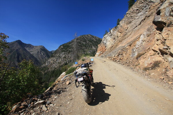
Father and son contemplate the first of many switchbacks before getting to the bottom.
IMG_2706.JPG


The rest of the way down
IMG_2720.JPG


Colorado River at the bottom.
IMG_2710.JPG


We also visited Canyonlands NP where we saw Mesa Arch
IMG_2726.JPG


IMG_2727.JPG


And we saw Grand View.
IMG_2730.JPG


At this time, Trevor had been paid his meager wage and we continued to Logan, Utah where I unloaded my bike and gear. At that point, I realized that I left my tail bag in Texas. Well, I really didn't need a rain suit, an electric jacket liner, winter gloves, a computer or a hoodie. Walmart did provide a rain suit and, as I will explain later, the rest of my gear also showed up. Randy and the vastly underpaid Trevor continued to Idaho and their own adventures while I quickly found a campground and about 12 hours of sleep.

The next morning, I headed toward Jackson, Wyoming, Grand Teton NP and Yellowstone NP.

I saw this lady beside the highway waiting on her husband to get back from town with a tire that had air in it. A home made house/kayak carrier.
IMG_2734.JPG


This is Bear Lake. It has been geographically isolated for over 100,000 years and combined with it's unique chemistry, has resulted in the evolution of 4 fish species found nowhere else.
IMG_2735.JPG


Afton, Wyoming has the worlds longest elk antler arch. They also had a great kung pao chicken plate which is now empty and my tummy is now full.
IMG_2738.JPG


I just happened to to see this raft coming down the river and back tracked to this rapid where I waited.
IMG_2744.JPG


My first glimpse of the Tetons. My visit to The Tetons and Yellowstone will be brief since I just spent three weeks there last year with my wife and a Burgman 650.
IMG_2748.JPG


I went down a dirt road that a ranger suggested. I had asked about a campground and he laughed and said most in the park filled up before 10:00 AM. There was rustic camping along a creek at the end of the dirt road he suggested. This family of 4 was Covid19 camping and home schooling across America. They even brought their washing machine and dryer. The twins were loving their lifestyle. I'm not so sure about mommy and daddy.
IMG_2749.JPG


Looking up river to my camp which I am sure is prettier than any in the main park.
IMG_2752.JPG


End of day 1 of riding, not counting the short ride down Shafer trail in Canyonlands. 64 days to come.
 
I woke up early, but nobody else in the campground did. I quietly cooked oatmeal with dried strawberries on my home made beer can stove. The stove started a small leaf fire and I realized I would have to buy a commercial stove that stood off the ground so I could cook safely in the dry conditions I was encountering while cooking on the ground.

As if designed by a team of theme park designers, Teton is mountains and water repeated over and over.
IMG_2769.JPG


IMG_2786.JPG


I inserted a motorcycle before continuing to Yellowstone by the southern entrance which I knew to be much less crowded than the west entrance
IMG_2773.JPG


Yellowstone is also about water, but the majority of it is heated water. The Yellowstone River is not hot. It does have some pretty spots such as the upper falls with an arched bridge in the background.
IMG_2797.JPG


You get this view of the Lower falls if you hike the Uncle Tom trail. This happens to be a different Uncle Tom than most are familiar with. The trail was closed about half way down, but this view is different than the Artist Point view. 308' straight down.
IMG_2800.JPG


I camped in a national forest campground which I tried to do every night just for the convenience of the table.
IMG_2805.JPG


I met a guy from Grand Junction and he has a friend that lives in Bryan, my home town. They both work for the same elevator company and his friend once got me out of a stuck elevator on the campus of TAMU.

I followed along the shell river headed toward Cody and discovered this nice waterfall.
IMG_2825.JPG


As they would do many times on this trip, my plans for the day changed due to Covid19. So many museums were closed, that I just quit trying to go to them. This time I headed to Medicine wheel where giants play golf.
IMG_2826.JPG


Not really, it's actually an ancient religious site where ceremonies are still performed and the ancient and not so ancient dead are still remembered and honored.
IMG_2837.JPG


There are hundred of artifacts that have been left over the years, including antlers, Jewelry, flags and many more.
IMG_2838.JPG


Giant fields of Lupine were nearby
IMG_2843.JPG


A strenuous 4 1/2 mile hike will get you this view of Bucking Mule Falls in Devil's Canyon.
IMG_2871.JPG


The same hike will get you this stunning view of Devils Canyon, but without my hairy knee.
IMG_2876.JPG


I had seen pictures of Bucking Mule Falls from the bottom so that afternoon, I went into Lovell which is about 20 miles away and asked a waitress in the local ice cream/hamburger parlor if she knew how to get to the bottom. She told me she had never been to the falls and as she turned toward the cook who was right behind her, the cook said, "Don't look at me, I've never been there either." Only 20 miles from where they lived their entire 35 or 40 year lives and they've never been. I drove 2,000 miles to see it.

I camped at 5 springs campground. My site had 2 tables, a fire ring, electricity, sewage and water, all for $3.50. After I got set up, I did a tour of the campgrounds and realized I had set up camp in the camp host site and the second table was just there to block idiots from camping there. When I got back, there was an Africa Twin laying in the middle of the road and a young lady sitting beside the road on a rock. Her husband was removing luggage to lighten the bike so he could pick it up and she was dressing a cut that would eventually require 24 stitches.
His Mosco luggage remained in my camp while they hitched a ride with another camper to the town of Lovell.
IMG_2880.JPG


The dead end road to my campsite. it used to be the main highway.
IMG_2893.JPG


I rode a loop that included Dead Indian Pass and Beartooth highway 2 times. I also rode Beartooth to Red Lodge and back twice.
The reason it's called Dead Indian.
IMG_2896.JPG


We have a modern bridge over this canyon on Chief Joseph highway, but I'm not sure how the indians and calvary negotiated this canyon.
IMG_2906.JPG


Just beside the road. I wonder if people from mountainous states come to Texas and stop beside the road and just stare at prairie.
IMG_2907.JPG


Beartooth highway
IMG_2918.JPG


IMG_2928.JPG


There is a grizzly bear momma and 3 cubs in this picture. This is the best I could do with a 10-22mm lens. My phone took a much better picture, but alas it's demise will be narrated when I explain the return of my tail bag.
IMG_2932.JPG


AT twin guy returned to my camp to pick up his gear. Kasey had about 1/2 a cup of gravel removed from her left knee and 24 stitches. AT guy is going to ride to Cody to rent a car, return to Lovell to pick up Kasey, drive back to Cody to pick up his bike and then both will drive/ride back to South Dakota. Good thing it was her left knee.
 
Last edited:
More lupines. They are closely related to Blue Bonnets.
IMG_2936.JPG


Back to Yellowstone
IMG_2940.JPG


The sign for Blacktail Plateau suggested bears, deer, elk and bison possible as well as "mountain ranges in every direction." I saw one old bison bull that was surely about to become wolf or bear food.
IMG_2946.JPG


This petrified redwood tree proves a much different environment in the past. There were once three of them, but souvenir hunters decimated them until all that is left is this skinny fenced remnant.
IMG_2943.JPG


Sheepeater Cliff, a lesser visited area of Yellowstone
IMG_2950.JPG


Even a brief trip to Yellowstone wouldn't be complete without a picture of a geyser and boiling water.
IMG_2955.JPG


A long time ago, the seed that germinated into this tree made a poor choice.
IMG_2961.JPG


Tonight's dinner was mac and cheese with a Huckleberry cream cheese cake for desert.

I saw a small sign directing people to a ghost town and decided to investigate.
IMG_2989.JPG


Housing was just adequate
IMG_2972.JPG


The bed inside. My guess is it's the precursor to the futon.
IMG_2971.JPG


It was not an equal housing sort of town
IMG_2978.JPG


It's been 7 days since my last shower. I went down another dirt road to Elkhorn Hot Springs, but the sign said, "Guest Only." Another day of camping
IMG_2992.JPG


The Montana American Legion puts up a white cross for every death along a highway. This one was slightly modified.
IMG_2996.JPG


My phone said this dirt road was a short cut to where I was going. it didn't mention any historical significance.
IMG_3007.JPG

IMG_3013.JPG


About 55 miles later, I came to Shoup, Idaho. I know the sign said 22 miles, but when you get 72 years old, you'll get lost too.
IMG_3017.JPG


Before closing, they were connected.
IMG_3018.JPG


No Motel, no shower.

I rode to Custer today on an old toll road.
IMG_3051.JPG


It's still dirt and I kept seeing these signs next to creeks
IMG_3063.JPG

IMG_3064.JPG


It took a while, but my feeble brain finally realized that these were modern signs labeling the creek crossings like mileage markers along an interstate highway and not similar names for creeks that were close together. It was all the same creek.

This is a rather tragic story of the death of an infant.
IMG_3071.JPG


Grave markers sometimes listed the cause of death. Suicide, snow slide and over drunk were alongside infant child.
IMG_3081.JPG


This is the home of one of the wealthiest families in Custer. I know they were wealthy because travel was a luxury in 1904 and the family of 5 went to the worlds fair in St. Louis.
IMG_3088.JPG


Old equipment such as this steam engine were all over the town of Custer.
IMG_3097.JPG


Back on the highway. I'm guessing the elevator got stuck in the "going down" position.
IMG_3109.JPG


I met Steve B on a BMW GS today. We discussed my trip and he was intrigued by my doing something on such a small bike. He's from one of the islands near Tacoma, Washington and we talked at the gas pumps while his partner went inside to buy beer. He offered his sail boat as lodging if I came to his island and offered me a ride in the bay on his speed boat.
Camping again today. I rode 183 miles to end up 59 miles from where I started. I must get a motel or at least a campground with a shower tomorrow. It's been 9 days.

The armor in my jacket is starting to crumble. I stopped in Salmon and the local shop didn't have clothing, not even T-shirts.
 
I love 5 springs campground. Did you leave your stuff at camp and ride the big loop or pack up each day?

You also mentioned your armor started crumble after not having a shower for 8 days.
 
My armor is over 10 years old. I hope that's the reason it's crumbling. If I was going to camp in the same place, I have always left all of my gear in the campground. I've never had a problem with theft in a camp. I did have a problem with theft off the bike for the first time ever.
 
Last edited:
Salmon River
IMG_3111.JPG


Same river less than 100 miles away, by highway.
IMG_3127.JPG


I went to Boise to get a new riding jacket and a local shop sent me to Carl's, a very interesting shop. Ready to go
IMG_3135.JPG


Do it yourself

IMG_3136.JPG


After leaving Boise, it wasn't long before I saw Rudolf.
IMG_3145.JPG


Payette River.
IMG_3148.JPG


Highway 21 south of Loman and highway 17 west of Loman are excellent. While Idaho does not have any national parks, it offers superb riding.

If you are on a curvy road in Idaho, chances are a river runs through it. This is near Warm Lake. The roads were great, the scenery OK.
IMG_3163.JPG


UhOh. Good thing I stopped before this got sucked around the front sprocket. I robbed a right side cover bolt.
IMG_3165.JPG


Motel!! 2 showers

First oil change at 2,640 performed behind a Dollar Tree. Others will all be closer to 2,000.

A water park in Cascade provided a wave for these 2 little girls to surf upstream. Several guys were also trying, without as much skill. The river is natural, but the waterfall is man made as was another for kayaks.
IMG_3167.JPG


Next up, Hells Canyon, North America's deepest river gorge at 8,000'. There is a series of dams built starting in 1957 in Hells Canyon. Idaho Power gets the electricity, but the feds tell them how much water has to be released from each dam.
IMG_3173.JPG


Looks bigger than a creek to me
IMG_3191.JPG

The lakes blocked the salmon run and fish ladders allowed the salmon to get upstream to spawn. The problem was, the fry would exhaust themselves swimming downstream in the lakes with little current. Now, salmon are captured at the lowest dam and artificially spawned in hatcheries before being released below the dams.

Graffiti I can accept
IMG_3195.JPG


Ospreys in an artificial nesting site. Two fledglings look like they are ready to fly the coop.

IMG_3200.JPG


Did I mention good riding in Idaho and eastern Washington?
IMG_3208.JPG


Typical breakfast. I alternated between a box of oatmeal and a box of cereal, but the oatmeal would last more days than the cereal. Fresh fruit was never a problem, even in smaller convenience type stores. In Washington, apples grew beside the road as well as blackberries everywhere. My new stove can be seen in the background.
IMG_3215.JPG


End of the road going to an overlook of ****'s Canyon.
IMG_3221.JPG


The old Chief Joseph is buried in the town of Joseph
IMG_3225.JPG


Apparently, he is still revered.
IMG_3227.JPG


Rightly so if these quotes are accurate and the local tourist center lady says they are.
IMG_3230.JPG


IMG_3231.JPG


IMG_3232.JPG


His son, Young Chief Joseph, defied an order to relocate to a reservation and skillfully avoided the US Army that was pursuing him for 1,170 miles. that probably wouldn't be incredible except there were 700 Indians, including women and children, and over 2000 horses. The American public was actually rooting for the Indians after the general in charge of capturing them said they were hard to track. Newspapers in the east ran cartoons depicting the odiferous dropping from 2,000 horses going into the sunset, with the army brass looking confused and scratching their heads.

Joseph Canyon is named after the two Chief Josephs.
IMG_3238.JPG


And, it's well worth a look and a ride. 3 times.
IMG_3244.JPG


Rattlesnake Pass-Recommended by a fellow TWTer
IMG_3248.JPG


When I got to Clarkston, Washington, I thought to myself, "There's probably a Lewiston somewhere around here." Sure enough there was one just across the river in Idaho. I got a motel before heading back east across Idaho.
A wheat fire, a preview of what is to come
IMG_3249.JPG

a closer look
IMG_3250.JPG


I was looking for a place to camp and a lady in a convenience store suggested going down this road.
IMG_3259.JPG


Looking good until
IMG_3265.JPG


Backtracking, I stopped at this sign when a local stopped to see if I needed help. He directed me to the river below.
IMG_3266.JPG


IMG_3271.JPG


Where I met this couple that offered me a large pork steak wrapped in bacon, fried sweet potatoes and grilled mushrooms.
IMG_3276.JPG


The direction giver had these 48" saw blades in his pickup bed
IMG_3270.JPG


I am now more than 25% done with my vacation.
 
Last edited:
Headed to Elk city, I came across this half tunnel
IMG_3285.JPG


The town of Elk City, Idaho, population 202, has a tank and a park honoring their veterans.
IMG_3287.JPG


They also have a Sheriffs Department with public restrooms.
IMG_3289.JPG


They have The Store which isn't that unusual until one goes inside.
IMG_3295.JPG


Inside The Store has: A full meat counter with a meat cutter on duty.
IMG_3291.JPG


Produce
IMG_3292.JPG


Nails, gas cans, hydraulic hoses and much more.
IMG_3293.JPG


Next door was the restaurant/bar
IMG_3297.JPG


Again, I got directions from locals. Two of them this time. I was assured my bike was adequate to ride the Selway Fall road to highway 12.
IMG_3307.JPG


As it turns out, my bike was adequate if the road had not been barricaded with a fence and gate. The lock and chain were completely covered in rust and must have been there at least 10 years judging by the size plants growing through the gate. Back the way I came.

When I got to highway 12 I was greeted by this welcome sign. It makes me glad I was on a DRZ400SM.
IMG_3314.JPG


It was winding and it was fun. I ended up camping at the powell ranger station which is very popular with bicycles and motorcycles. Camping is free for 2 wheelers, but most motorcycles were parked in front of cabins.
My camp.
IMG_3316.JPG


Father/son cross country bicycle riders
IMG_3317.JPG


An elderly lady on a DRZ400S. She's the planner and leader of a group of 5 doing as much dirt as they can. They were turned back by the same road closure that I encountered, just from a different side. I believe all the others were on Husky 701s which seemed very popular in the NW.
IMG_3320.JPG


A couple of her followers
IMG_3319.JPG


I stopped at the Honda/Yamaha dealership in Missoula, Montana for a couple of oil filters. They don't work on Suzuki motorcycles, but they could order me some filters. The Suzuki/Yamaha shop 50 miles north of Missoula didn't sell Suzuki motorcycles, or Yamaha motorcycles for that matter, but they did have 2 filters for my bike. 4,200 miles since starting the trip so the second change is due

Next up I went to St. Ignatius church in the town of the same name. It was closed, not due to Covid19, but due to construction.
IMG_3323.JPG


The most exceptional feature of the interior are the 58 murals painted by Brother Joseph Carignano, an untrained artist who worked as a cook in the mission. I wanted to see those murals.
An example I borrowed from the internet.
st i.jpg


I headed toward Glacier NP and stopped at the Hungry Horse Dam.
IMG_3336.JPG


My camp was on the west side of the dam. I had stopped at Safeway for groceries and as I neared my bike, I dropped my phone. Being only about 10 feet from my bike, I hurried to set the grocery bags down. Someone ran over my phone. He said he swerved to miss it, but he would have missed it if he had stopped or not swerved. I have become dependent on my phone to keep in touch with my wife. She is going to send me a new phone and I will get my tail bag with my hoodie and my electric jacket liner. YES, Yess to electricity. I lost all my pictures on the phone.
 
OK i'm all caught up and ready for today's installment.:coffee: I hope to learn to travel this way some day. I always seem to be in a hurry and pass everything up just riding or driving. I can't seem to stop and take pics and investigate things.
 
OK i'm all caught up and ready for today's installment.:coffee: I hope to learn to travel this way some day. I always seem to be in a hurry and pass everything up just riding or driving. I can't seem to stop and take pics and investigate things.
It's a challenge to be sure. If I'm riding alone it stands a lot better chance of happening. When you look at that part plus spending way bunches of time afterwards going through pix trying to remember what I'm looking at and then stringing it all together and writing up something worth reading...well, it's just a wonder it ever happens. Rarely done with this kind of quality. Is it time for the next episode yet???
 
Glacier is hard for me to capture. The road through the park is narrow and it seemed like every time I wanted to stop and take a picture, there were no turn outs. I should have taken my GoPro.
IMG_3341.JPG


IMG_3349.JPG


The Blackfeet Nation has stopped all travel by non tribe members and our national park system is honoring their request. this is the turn around point at Rising Sun Picnic area.
IMG_3362.JPG


St. Mary and McDonald lakes are available
IMG_3367.JPG


IMG_3371.JPG


Glacier, like most of the national parks, was crowded.
IMG_3382.JPG


About this time, my bike could have used a shower, but traffic and narrow shoulders only allowed a stop N go picture.
IMG_3390.JPG


Even the tunnels in Glacier are prettier than most tunnels
IMG_3392.JPG


I should have hiked in Glacier. I'm not sure why I didn't, maybe because it was early in my trip. At this point, I have done nearly zero hiking.
This nice waterfall across the canyon would have been a nice candidate to hike to.
IMG_3393.JPG


Three men died constructing the Going to the Sun highway, finished in 1933. With all the blasting and hanging from ropes, it's amazing that the figure is so low. The rocks and debris from the tunnel blasting was removed by hand.
IMG_3415.JPG


IMG_3420.JPG


IMG_3419.JPG


There was a language barrier so I don't know what the occasion was, but this lady and her "man" agreed to let me take her picture.
IMG_3427.JPG


A restaurant had a PIE sign next to the road and I decided to investigate.
Cheri's Pie Bar had excellent huckleberry pie. I suggest you try some if you are ever in West Glacier.
IMG_3433.JPG


From my notes: "Glacier was cut off at Rising Sun, but from Lake McDonald to Rising Sun was "ooooh" after rounding every turn. It was unreal." Before this trip, my favorite park was Glacier. During this trip, it was usually the one I was visiting or had just finished visiting. My favorite is gravitating back to Glacier.

My camp for two nights. Where the road dead ended. Six camping days in a row.
IMG_3437.JPG


The next day was a buy a phone, take a shower, do some bike maintenance, eat restaurant food, and do laundry kind of day. I was unable to buy a phone. The phone service required me to log in with a computer or give them a number so they could call me. I'm on a trip. I don't have a computer. IF I HAD A PHONE FOR YOU TO CALL ME THEN I WOULDN'T NEED A PHONE. Rant over. Linda agreed to get me a phone and send it to me.

If you do your laundry while you shower, it accomplishes many things. It saves water. It allows you to wash ALL of your clothes without wearing anything. It saves you $5. It gives you at least an extra hour in a real bed. My 72 year old bones like the last one.
IMG_3442.JPG


Only 99 miles yesterday. Today I made my first detour from my route. I didn't actually have a route, just a general idea of what I wanted to see, but four national parks in Canada was part of that general idea. Covid stole 0ver 1,000 miles from my trip.

My dining room for lunch today.
IMG_3444.JPG


I rode highway 37 on the east side of Lake Koocanusa and after gassing up in Libby, an unnamed road on the west side of the lake. When I saw a sign Yaak 42 miles, I turned left. The west side road and the detour to Yaak remind me of back roads in North Carolina, with good pavement, tight turns and lined with trees. I got lost. My GPS will not find Yaak. When I asked it to find nearest gas, it took me to Yaak merchantile.

This large eagle was in Libby, Montana. It probably had a 12' wing span. Several other eagle sculptures about life size were on display in the small town. I don't know the significance.
IMG_3451.JPG


Another tree that picked a very disappointing spot to germinate.
IMG_3448.JPG


The road to Yaak. My kind of road. Did I mention the DRZ was the perfect bike for this trip?
IMG_3460.JPG


Yaak Falls
IMG_3465.JPG


I've seen several sway backed horses on this ride, but this is the first sway backed 18 wheeler I have ever seen.
IMG_3467.JPG


I built a wooden canoe, but someone built a rowboat out of plywood. It's seen better days.

IMG_3469.JPG


An old depression era CCC camp has been converted into a monument to the young men that gave us so much beautiful work.
IMG_3481.JPG


IMG_3485.JPG


IMG_3483.JPG


The local state park was nearly full and no economy sites were available. It would have cost me $67 to camp there because they also required a yearly parking permit that was $35. Washington also requires a $35 parking permit in most areas, even in most scenic turnouts. Daily parking in both states is $10.
IMG_3486.JPG


I stayed in this private camp with showers for $17.

IMG_3487.JPG


They did have some rules posted. I'm really not sure if they are serious rules or not.
IMG_3488.JPG

A sign beside the BBQ pit said, "No Smoking."

Big people could play checkers.
IMG_3491.JPG


Washington state coming up along with a road that Butler maps calls one of the top five motorcycle roads in the 48 states.
 
Last edited:
Excellent report and wonderful pictures!! :clap:

Not many people do reports anymore. I guess it is easier to post stuff on FB, Instagram, Whatsapp, etc,... :shrug: So thanks for taking the time to share with us :thumb:
 
I need to finish my fork seal replacement today, so I will continue tonight. Thanks to all for the compliments.
 
6 outta 5 star report! :clap::dude:
Amazing pics, great narrative.
You've made me think about lubing up some of the old rusty gears of my body. A trip I did from WA to TX in June of 1981.
1601388341516.png
 
I'm in awe of all the cross country and multi state bicycle riders I saw.
 
I rode from Republic, Washington to Winthrop, Washington, a distance of 110 miles according to Google Maps. Somehow, I stretched it to 331 miles. Part of that 331 miles was a trip through Cascades NP and back to Winthrop. Butler Maps calls this stretch of highway one of the top 5 motorcycle roads in the 48 states. If the number of times I rode it is any indication, I must agree.
IMG_3499.JPG


IMG_3516.JPG


Apple trees grew along the road.
IMG_3552.JPG


Winthrop had a visitors center. The lady working there allowed me to call my wife with her phone and to use the visitor center as a post office. Three days later, I had a new phone and electric underwear. When I asked what it would cost for a tent site for three nights the lady at the Winthrop KOA told me $49. I said OK. When she handed me the print out, it was for $159. $49 was per night, plus tax. No thanks. A national forest site was $4 per night.

In the meantime, I needed something to do. What to do for 3 days? Well, I did have a national park and I had a historic site just up a dirt road.
Northern Cascades
IMG_3527.JPG


I picked a hike to Blue Lake. A hike of a little over 5 miles would still allow me to ride back through the park.
IMG_3528.JPG


Maybe Green Lake would be more appropriate.
IMG_3538.JPG


For scale, I waited on two people and their dog to get to the other side of the lake. That looks like fun, doesn't it?
IMG_3546.JPG


Better?
IMG_3547.JPG

Blue lake is definitely worth the hike. I was worried about leg cramps after the hike, but I obeyed the bear warning signs in the campground and didn't take any V-8 juice into my tent. I am susceptible to leg cramps and V-8 juice knocks them out within 30 seconds. Cramps came. They were so bad, I fell on my chest getting out of my tent. After the cure worked, I spent 20 minutes with hand lotion and a comb trying to get pine needles and pine pitch out of my chest hair.

The next day, I rode up to a cold war radar installation on this dirt road.
IMG_3554.JPG


It was a scenic dirt road.
IMG_3591.JPG


IMG_3559.JPG


IMG_3578.JPG


The military cut the top off slate peak in order to install their radar
IMG_3569.JPG


When the cold war was over, the military no longer used the radar site. The forest service built this observation tower to the same height that the mountain used to be.
IMG_3572.JPG
 

Attachments

  • IMG_3554.JPG
    IMG_3554.JPG
    447.9 KB · Views: 192
Back
Top