• Welcome to the Two Wheeled Texans community! Feel free to hang out and lurk as long as you like. However, we would like to encourage you to register so that you can join the community and use the numerous features on the site. After registering, don't forget to post up an introduction!

Mountains, Rivers, Canyons, Lakes, Statues and Oddities, Both Domestic and Foreign, Then Repeat

July 4th

Out of the high mountains and headed to John Day. I'm not sure who John Day is or was, but there's a town with his name and a town called Dayville. There's also a John Day National monument which I was encouraged to visit.
IMG_9182.JPG


IMG_20230703_173824200_HDR.jpg


I stopped in Dayville to eat breakfast. The cook told me he was going to watch the parade and the waitress could cook for me. I decided to watch the parade and eat afterwards. For such a small town, they really had a nice parade. This guy was just cruising through town, not part of the parade. I was told I could join in the parade on my bike if I wanted to. I remember the jail scene in Easy Rider and declined.
IMG_9193.JPG


This little girl was adamant that she wasn't going to share her ice cream.
IMG_9196.JPG


All ages showed up.
IMG_9202.JPG


What's a parade in the west without horses?
IMG_9206.JPG


Need a Jeep also.
IMG_9208.JPG


Don't rent pigs and don't spell. Presnts may have been intentional.
IMG_9213.JPG


Old tractors driven by old men.
IMG_9214.JPG


Old cars.
IMG_9221.JPG


Even older cars with hand crank starters.
IMG_9229.JPG


There was so much candy thrown from the participants in the parade that kids quit picking it up.
IMG_9233.JPG


Back to the breakfast. While I was eating breakfast, I saw four people leave without ordering. Each left after seeing the wolf skins for sale. Wolf skins sales can't be a high percentage of sales in a restaurant. The killing of wolves is such a volatile topic that the owner of a business has to know that he's going to lose business if he sells their skins. There were only three tables inside, so I moved outside finished my coffee and wrote in my notebook at an outside table. When I was about 30 miles away from the town, I realized I had forgotten to pay. Zip back.
IMG_9234.JPG


Zip back through this ain't bad.
IMG_20230704_125447524_HDR.jpg


IMG_9238.JPG


Painted hills in John Day NM
IMG_9239.JPG


A couple visiting Dayville for the July 4th parade started chatting with me. They once rode motorcycles and suggested I ride highway 242 from Sisters, Oregon to McKenzie. His description was, "It's so twisty and the curves are so sharp that your front wheel will run into your back wheel." While I didn't actually do that, the road had the highest concentration of sharp turns of any road I was on during my trip. Scenery wasn't bad either.
IMG_9246.JPG


IMG_20230705_111321741.jpg


I don't know why it was built, but it was interesting.
IMG_9248.JPG


IMG_9249.JPG


Oregon also has three sisters. In Texas the Three Sisters are the hottest road around, in Oregon the Sisters are actually volcanos. Here's two of them with lava fields stretching for miles around them and the highest concentration of Glaciers that far from the north pole.
IMG_20230705_111642905_HDR.jpg


IMG_9252.JPG


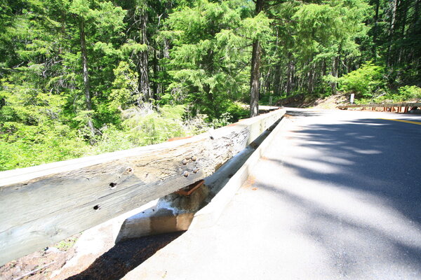
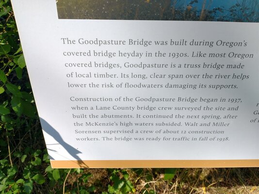
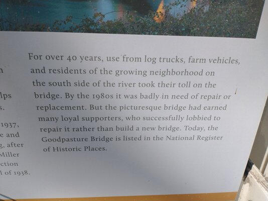
The Goodpasture Bridge was built in the 1930s and rebuilt about 50 years later.
IMG_20230705_163421710_HDR.jpg


To get a long clear span to prevent the bridge from being washed away during spring floods, a truss system had to be built to temporarily hold up the bridge until the supporting structure could be completed. That meant construction had to wait until after the spring snow melt and had to be finished by winter. The sign said it took a twelve man crew to accomplish the task.

IMG_20230705_163934791.jpg


I stayed in a NF campground and discovered more rock art.
IMG_20230705_185922538_HDR.jpg


IMG_20230705_185927179_HDR.jpg


I don't know if this was a mistake, or someone took offense and threw one of the rocks into the river. I didn't disturb it.
IMG_20230705_190132556.jpg
 

Attachments

  • IMG_9256.JPG
    IMG_9256.JPG
    593.9 KB · Views: 52
  • IMG_20230705_163921215_HDR.jpg
    IMG_20230705_163921215_HDR.jpg
    276 KB · Views: 65
  • IMG_20230705_163927328.jpg
    IMG_20230705_163927328.jpg
    204.4 KB · Views: 48
IMG_9268.JPG


IMG_9272.JPG


IMG_9273.JPG


Called the Office Bridge, it's the longest covered bridge in Oregon.
IMG_9275.JPG


Still in use, the visitor's center is on the other side of the bridge from the highway.
IMG_9276.JPG


IMG_9278.JPG


Tonka trucks on a fence
IMG_9284.JPG


IMG_9287.JPG


On a house
IMG_9288.JPG


I went on this dirt road because my destination looked a lot closer on dirt than on the highway. I got lost, but it was a pretty area.
IMG_20230706_132323409.jpg


They were serious about the "one Lane."
IMG_20230706_132520234.jpg


IMG_20230706_143709102_HDR.jpg


IMG_9303.JPG


At this point, I was tempted to get out the GPS and find out exactly where i was.
IMG_20230706_145626828_HDR.jpg


I found my was to a free national Forest campground. I chose this one because a camper at a convenience store told me not to camp on the lake because of the abundance of flies and mosquitoes. The mosquitoes are not showing up, but there were a large number trapped between the tent and rain fly..
IMG_20230706_195705161.jpg


July 7th. I woke up to mosquitoes, so I ate a quick breakfast that was interrupted by mosquitoes landing in my oatmeal. I gave up after the third one and headed to Crater Lake.
IMG_20230707_073134339_HDR.jpg


Cleetwood Cove is the only authorized access to the lake. They have tour boats and a tender boat in the lake for guided tours around the lake. One of the guides told me they had all been recently replaced. They were placed in the lake by helicopter and the old ones removed the same way.
IMG_9314.JPG


Crater lake is stunning
IMG_9308.JPG


The walk down to Cleetwood is easy. The stuff floating on the water is pollen.
IMG_9316.JPG


New boats being used for the first time to train guides. Tourists will have to wait a couple of days.
IMG_9324.JPG
 

Attachments

  • IMG_9328.JPG
    IMG_9328.JPG
    238.7 KB · Views: 57
I guess I paid too much attention to the hot dogs at the cafe. I did not realize there were boats. That would be very cool indeed.
 
The water is really cold. Crater Lake is nearly 2,000' deep, has the cleanest water of any lake in the USA and last froze over in 1949.
IMG_9326.JPG


Swimming is allowed. With melting snow lining much of the shoreline, I opted to not swim.
IMG_9328.JPG


Tree pollen is floating on an otherwise clear lake.
IMG_9330.JPG


IMG_9340.JPG


Snow along the rim road on the outside of the Crater on July 7th. The Rim Road was only open about 2/3 of the way around the crater.
IMG_9350.JPG


A headless Statue of Liberty.
IMG_20230707_102454817_HDR.jpg


IMG_9351.JPG


Vidae Falls, one of the outlets for the lake that allow the lake to remain fresh water.
IMG_9361.JPG


The trail to the Pirate Ship Island over look was still snowed over, but open.
IMG_20230707_122136678_HDR.jpg


Decomposition of organic material built up around trees aids in melting snow circles.
IMG_9364.JPG


IMG_9372.JPG


Pirate Ship Island peeking between trees.
IMG_20230707_122353272_HDR.jpg


Mount Theilsen, extinct for 250,000 years. The rugged mountain was shaped by glaciers.
IMG_9381.JPG


Clearwater Falls. Waterfalls never disappoint me, but after the hike to get to this one, it was a close call.
IMG_9382.JPG


July 8th. I need tires and there is a Cycle Gear that is only about 150 miles out of my planned route. Well, I planned it this morning. Lot to see along the way. This view of the chasm gives us an idea of how little soil is available for the trees.
IMG_20230708_101558519_HDR.jpg


The Fir trees have joined together for survival. Even though this tree has been cut down, the stump still lives off of the food production of the needles of the adjacent trees.
IMG_9398.JPG


Hike to this one
IMG_20230708_115846434_HDR.jpg


:doh::roll::roll::roll::doh::doh::roll::roll::roll::doh:It gets worse
IMG_9401.JPG


IMG_9403.JPG
 

Attachments

  • IMG_20230707_121331208_HDR.jpg
    IMG_20230707_121331208_HDR.jpg
    838.3 KB · Views: 49
  • IMG_9340.JPG
    IMG_9340.JPG
    199.5 KB · Views: 45
  • IMG_20230707_105633177.jpg
    IMG_20230707_105633177.jpg
    390.4 KB · Views: 46
Last edited:
I bought a rear tire at Cycle Gear in Medford, Oregon. They didn't have a 120/17 tire in stock. I thought that was very unusual since most sport bikes use that size front tire. Oh well, the rear needed changing much worse than the front. I started talking to two young guys. They were fascinated that I was on a long trip on a 400cc bike. When I mentioned that I was headed to Klamath Falls to get a motel and change my tire, they wanted to go along, at least past the twisty part. A TWT member, Lickitysplit had mentioned highway 66 as being a nice motorcycle road. Both of my newfound riding partners were excited about riding it and said they had ridden it many times. I followed at a pace that was too fast for street riding, especially on semi knobby tires. They were on a Ninja 250 and a Yamaha 300. With all the talking and planning, I forgot to get gas. Luckily there was a station in a small community about 15 miles before Klamath Falls. This is a picture of the tank with the bike leaning to the left. I had already stopped twice to lean the bike over so the gas trapped on the right side could get to the petcock. Look closely at the gas line about 1/2" up from the bottom of the tank.
IMG_20230708_155305553.jpg


I have a 3.9 gallon tank.
IMG_20230708_155532455.jpg


I change my rear tire, washed clothes and ate in a restaurant that night. The next morning I had a decision to make. I could head back to Canada or head towards home. I had received a text from my neighbor the day before. She had sent me a picture of her two year old daughter sitting on my front porch. The two year old was crying because I wasn't home. That day was the first time I have ever let a child determine my route. Google Maps said it was about 2,100 miles back home and I intended to make it in 3,500 miles of riding.

It was Sunday morning and I needed to find a new front tire. I called Cycle Gear in Reno, NV and they had street tires, but nothing close to what I would need to ride the White Rim trail and others near Moab, so I decided to wait until Tuesday when other shops would be open. Highway 447 headed toward Reno, but not to Reno, a town that I hate riding a small bike around.

Note the absence of trees except cedar bushes and sagebrush.
IMG_9405.JPG


I had to assume that I had found a new variety of pine cone bearing sagebrush, because that was the only large plant in sight.
IMG_9406.JPG


For about 50 miles I saw no evidence of civilization except for the road and fences, until these trees came into sight. No house, no driveway, but a clear indication of planted trees in the Nevada desert.
IMG_20230709_112731548.jpg


After about 75 miles of empty, I spotted more evidence of the Humanrace. I don't know what they were selling, but I wasn't buying.
IMG_9410.JPG


Bruno's cafe in Gerlach, Nevada, population 28.
IMG_20230709_133136810_HDR.jpg


The loneliest highway? Just me and my shadow.
IMG_20230709_183517069.jpg


Things got a little freaky when I did a U-turn back to this modified sign for "Open Range, Cattle on Highway." Note the #19 on the bottom of this sign. I stopped at other signs. Some didn't have numbers, but those that did were all different. I had a friend that died, over 20 years ago, in turn 9 at Texas World Speedway. His name was Ryan Smith and his number was 19. Ryan was a happy guy and was always smiling. The guy on the cow was smiling. I texted this picture back to several of my racing buddies. I didn't say anything about the picture, but I did point out the #19. The implication may have been that Ryan is now riding cows. Implications gets freakier later.
IMG_20230710_135750722.jpg


This "Wild Horses on Highway" sign was #22.
IMG_20230710_140111034.jpg


I saw a sign that said _______ spring. I went down this road in search of a spring, maybe. This was as far as I got.
IMG_9412.JPG

I rode 520 miles today and stayed in a motel, the second night in a row. At this point, my wife knows that I am heading toward home and she encourages me to stay in motels instead of camping. I think she believes that I'll get there quicker if I don't spend time setting up camp and taking down tents. The reason I stayed in motels is the extreme desert temperature.

A gate north of Great Basin NP
IMG_9413.JPG


Those of you that read my report, "67 days is not 5 months," may remember this gate to a meat processing plant and an elk horn chandelier manufacturing plant.
IMG_9414.JPG


This library was outside a convenience store/bakery/bookstore in Baker, NV.
IMG_9417.JPG


I didn't go into the Great Basin NP. I've been there twice in the last three years. I did go to the visitor's center which was nice and informative. The great basin is described as an area that has no outlet to the sea. Death Valley is part of it, as well as the Great Salt Lake. A map is below.
IMG_9420.JPG


They have this rifle on display. It's called the lost Winchester because it is estimated that it weathered 100+ years leaned against a Juniper tree. At one time, it was loaned to the Buffalo Bill Museum in Cody, WY.
IMG_9421.JPG


X-rays show a cartridge lodged in the stock.
IMG_9430.JPG


IMG_9423.JPG


This is a section of a bristlecone pine tree that was estimated to be 4,900 years old when it was cut down for research in 1964. It germinated when the Giza pyramid was being built
IMG_9426.JPG


IMG_9431.JPG


Our motel room in Chisos Mining Motel had a similar sign to this one in a convenience store in northern Utah.
IMG_20230711_132635493.jpg


At the end of this road, I found a front tire at Prime Honda in Nephi, Ut. Mounted and balanced. Yea, I hate changing the front tire. If I don't have a way to stabilize the bike and get the front tire off the ground, I have to unload everything and lay the bike on its side. Much more time consuming than doing a rear.
IMG_9438.JPG


Washing machines like this could be very dangerous. I had nightmares as a child.
IMG_20230711_154320786.jpg


This looks like southern Utah because it is.
IMG_20230711_161013750.jpg


Bonsai prickly pear cacti.
IMG_20230711_173903590.jpg


Start of Burr Trail. It's getting late and I need a place to camp at this point.
IMG_20230711_174022582_HDR.jpg


IMG_9446.JPG


Nice spot along a creek.
IMG_9456.JPG


Uh Oh.
IMG_9459.JPG
 

Attachments

  • IMG_20230711_132525694.jpg
    IMG_20230711_132525694.jpg
    301.8 KB · Views: 49
  • IMG_9421.JPG
    IMG_9421.JPG
    206.9 KB · Views: 44
  • IMG_9408.JPG
    IMG_9408.JPG
    273.5 KB · Views: 44
Last edited:
I've been to Utah lots of times, but never to Brown's Lake.
IMG_9460.JPG


Four people were launching kayaks to go fishing. I met Sky and Bobbi from Kanab. They invited me to come visit.
IMG_9462.JPG


Their dogs had cornered a squirrel of some sort under some rocks. I was there for about 20 minutes and they hadn't given up when I left.
IMG_9463.JPG

Sky told me about a scenic lake that required 4WD. It was called Posey. When I ate lunch, I asked my server if she knew about it and she also suggested I go there. Using directions from two people, one phone, and one Butler Map, I got lost. I had a nice long ride through the woods, but didn't find Posey Lake.

Brown's Lake from the scenic turn out on highway 12.
IMG_9467.JPG


Also at a scenic turn out on highway 12, I met this guy from England. He comes over most years and ships his Harley. The $1,200 shipping each way is cheaper than renting. He leaves his trailer with friends in Pasadena. I didn't ask if it was Pasadena, Texas or California. Anyone know him? His bike has LOTS of miles on it.
IMG_9470.JPG


IMG_9468.JPG


IMG_9469.JPG


IMG_9473.JPG


The views along Highway 191 are splendid. I decided to ride the White Rim Trail in Canyonlands NP.
IMG_9475.JPG


IMG_9477.JPG


IMG_20230712_173016059.jpg


IMG_9479.JPG
 

Attachments

  • IMG_9482.JPG
    IMG_9482.JPG
    384.4 KB · Views: 42
I spent another night in a motel in Green River and the next morning I decided to ride into Canyonlands NP.

I stopped for fuel at a convenience store across the street from the road that leads to Canyonland's northeast entrance.
IMG_9482.JPG


The place is more than a convenience store. They have campground, showers and trails of their own. I'm hoping the 5 1/2 MPH is for the campground and not the trails.
IMG_9484.JPG


About 20 miles of beauty later, I entered the prize.
IMG_20230713_102440599.jpg


I try to do shafer trail every time I'm in Moab. It's easy, dramatic, accessible, goes close to beautiful arches and rock climbing areas, ends in Moab and is my preferred start to the White Rim Trail.
IMG_9486.JPG


The shelf about mid picture is the road.
IMG_9487.JPG


Going down.
IMG_9496.JPG


Still going down, but not as steeply.
IMG_9498.JPG


See why I always try to include Shafer?
IMG_9499.JPG


IMG_20230713_112100620.jpg


Before getting to the Colorado River, there is a road that goes to the left. It's the road to Moab and the one you're supposed to take if you can't get a permit to ride the White Rim Trail. I did not take that turn to the left as I was supposed to and had planned to do. I went straight. After about 10 miles I realized my mistake, but I couldn't believe I missed something so obvious so I continued another 10 or so miles. At that point I knew I was illegally on the White Rim and I knew I had to stop and change from a 16t front sprocket to my 13t sprocket. When I removed the sprocket cover, the sprocket nut fell off. It was stripped, but the shaft seemed fine. I changed the sprocket and put the stripped nut back on the shaft. It slipped right on. To keep it on, I beat the sprocket cover in until it rubbed against the end of the shaft. I retraced my steps back up Shafer Trail and back to the convenience store on highway 191. I decided I would try to get home with the stripped nut being held on by the bent sprocket cover. As I was changing the gearing back to street, I remembered that the front axle nut used the same size wrench as the sprocket nut. I tried it and with three washers I thought it would be fine. My front axle has pinch bolts so the nut was not 100% needed. Anyway, the cover would prevent the nut from slipping off if it became loose. Because the axle nut did not have a relief indentation to clear the portion of the gear shaft that protrudes past the sprocket, the sprocket remained loose on the shaft and the lock washer could not be used correctly.
IMG_20230713_151042205.jpg


My plans to spend two more weeks in Utah, Colorado and New Mexico were cancelled. I headed straight home. Well, as straight as I could go without getting on freeways.
IMG_20230713_151053979_HDR.jpg


Before my plans changed, part of the New Mexico tour was supposed to be the Bisti/De Na Zin Wilderness in New Mexico. I was too concerned about the sprocket nut to go into the wilderness, but some of the formations were near the road.
IMG_20230714_092040931.jpg


IMG_9503.JPG


IMG_9504.JPG


IMG_9506.JPG


I wanted to go to Pie town since I had missed a feature last year. This dirt road is apparently called a highway in New Mexico
IMG_20230714_135140106_HDR.jpg


A road going south of Pie Town will take you to The Toaster House. While I was eating pie, I told my waitress that I missed my turn to Toaster House and decided to just forget about it until the next time. She told me how close it was and that I should backtrack. I did.
IMG_20230714_145342450_HDR.jpg


Supposedly, hikers doing a trail in the desert would come to this Hostel and the owners would sometimes say, "You look toasted," Hikers started returning and bringing toasters to hang on the fence and the hostel is now known as the Toaster House.
IMG_9511.JPG


Remember the graffiti sign back in Utah with the man riding the cow. I implied to my racer friends that Ryan Smith was riding cows because his racing number 19 was on the cow sign. When I saw this #19, I immediately thought Ryan was tell me, "Dennie, you're toast."
IMG_9513.JPG


I spent the night in Roswell, NM and the fence around the motel garden was lined with shoes.
IMG_9514.JPG


It was so hot when I took this picture that I couldn't say I was happy to be back in Texas.
IMG_20230715_085546701_HDR.jpg


Between Post and Snyder, I saw Yosemite Sam.
IMG_9518.JPG


After 577 miles, I was home. I rode three days that were longer than 500 miles, but my daily average was way less.

Stats
75 year old rider with 61 years of riding experience.
Bike-2018 Suzuki DRZ-400SM with 25,241 miles on the odometer.
Ending mileage 36,956 miles for a total of 11,715 miles ridden.
Length of Trip-74 days total.
54 days of riding=217 miles per day
I spent 4 days driving my van to Montana and watching Spartan Races then driving 520 miles back into Wyoming where I started my bike ride.
I also spent 16 days riding in a rental car when my wife came to Montana to visit.
Changed oil 5 times
Changed tires twice because I had 3,000 miles on a set when I started.
First time to visit Canada
 

Attachments

  • IMG_20230713_151042205.jpg
    IMG_20230713_151042205.jpg
    268.1 KB · Views: 50
Last edited:
I have tentatively sold my 2018 DRZ with 37,000 miles on it and have replaced it with a 2020 DRZ-400SM with only 4,000 miles on it. Its my 6th DRZ. I think I'm hooked.
One thing, the replacement nut for the countershaft threaded right on the shaft, but the socket size has been increased. My home made socket/jack stand will not work on the new nut. I checked the nut on the 2020 DRZ and it is also larger than the one that came on 2018 and older bikes.
 
Thanks for all your efforts of picture taking and posting. After viewing all the pictures and reading the accompanying text I feel that I was part of the journey also. I particularly enjoyed the riding pants that were later found after a journey of their own; the episode of the dying bike when standing and squeezing the tank (good detective work); the house of Tonka toys; rock art in various places; the cow/rider on sign #19; the dog library. I too seek out waterfalls of which you encountered and documented many. I am overdue for another extended adventure...

Great posting! :clap:
 
I finally read all the way through your trip report, what an amazing trip and so many great pictures as well. Thanks so much for sharing it all with us.

So many aspects of your trip resonated with me, one because I too have been to so many of these places, some via two wheels and others via a 4WD. Banff is stunning and a must see IMHO, the Grand Tetons NP is one of my favorite National Parks but I have yet to see Glacier NP. I enjoyed seeing the old BSA, my first vintage restoration was a 1966 BSA Thunderbolt so they've always had a special place in my heart. I still have a framed 60's BSA advert poster in my man/gun room. The damaged Yamaha Enduro was disappointing to see as I just sold my 1974 DT250A that I restored during the pandemic so I have a soft spot for them as well.

It's interesting to see you travel on and prefer the Super Moto version of the DRZ, it requires such an odd off-road tire combo to come by for the SM wheels. I had a 2013 DRZ-S 400 for a hot minute back when I was still in the Army. It wasn't used much for any real adventures other than tooting around on post and in town with the occasional Saturday morning romp on local dirt roads when time allowed. I recall the only real fatty knobby I could find for it were Shinko tires which I oddly enough run a version of on my Honda CT125 Trail today. I sold that bike to a kid who was taking it to college with him in Lubbock, he was enamored with it and I wasn't too depressed about seeing it go. That said, it's cool to see someone traveling all over the country on one and it's no surprise that you prefer the bike in general because they are dead nuts reliable.

I look forward to your next adventure on the now new replacement DRZ-S that you've obtained. Any plans for different mods or setup on this new build?
 
Last edited:
I finally read all the way through your trip report, what an amazing trip and so many great pictures as well. Thanks so much for sharing it all with us.

So many aspects of your trip resonated with me, one because I too have been to so many of these places, some via two wheels and others via a 4WD. Banff is stunning and a must see IMHO, the Grand Tetons NP is one of my favorite National Parks but I have yet to see Glacier NP. I enjoyed seeing the old BSA, my first vintage restoration was a 1966 BSA Thunderbolt so they've always had a special place in my heart. I still have a framed 60's BSA advert poster in my man/gun room. The damaged Yamaha Enduro was disappointing to see as I just sold my 1974 DT250A that I restored during the pandemic so I have a soft spot for them as well.

It's interesting to see you travel on and prefer the Super Moto version of the DRZ, it requires such an odd off-road tire combo to come by for the SM wheels. I had a 2013 DRZ-S 400 for a hot minute back when I was still in the Army. It wasn't used much for any real adventures other than tooting around on post and in town with the occasional Saturday morning romp on local dirt roads when time allowed. I recall the only real fatty knobby I could find for it were Shinko tires which I oddly enough run a version of on my Honda CT125 Trail today. I sold that bike to a kid who was taking it to college with him in Lubbock, he was enamored with it and I wasn't too depressed about seeing it go. That said, it's cool to see someone traveling all over the country on one and it's no surprise that you prefer the bike in general because they are dead nuts reliable.

I look forward to your next adventure on the now new replacement DRZ-S that you've obtained. Any plans for different mods or setup on this new build?
Thanks, I'm glad you enjoyed it. I also like to read reports of riders that are in areas that I have ridden. When they tell about something that I missed and wish I hadn't missed, It reminds me to slow down and explore.

Glacier is similar to Banff and Jasper. I think the main difference is the size of the glaciers that formed them, which determined where the roads could be built. Glacier has a V shaped valley and there is no place to build a road in the bottom of the valley, They built it along the side of the mountain, giving riders a view across the valley as well as up and down. Going to the sun is like the Million Dollar Highway, only longer. The road through Banff is striking for over 300 miles, more if side roads are included. Both should be on every rider's bucket list.

I've had two S model DRZs and if I were going somewhere to ride jeep roads, I would prefer an S model. I like the way the 17" tire works on paved curves, it flicks, and most of my riding is on pavement. When I get on the dirt, I'm usually going somewhere to look at something. I modify my riding until the 17" tire can handle the terrain. I prefer to buy bikes as close to stock as I can find for a reasonable price. All 6 of my DRZs have been bought used. Only one has had an aftermarket pipe. My mods usually include exchanging the plastic between old and new and removing the safety and convenience features I have added. I have USB and SAE connectors for charging and for an electric jacket liner, a switch added to turn off my headlight when the jacket liner is used, luggage arrangements, hand guards and a belly pan. I splurge on short levers because that's what I used when I was roadracing and I like them. I use a 16T front sprocket and carry a 13T for when I need it.
 
I have a complaint!

Each post is too long, covers too much! Makes responding to something or asking a question more harder! šŸ˜œ

Seriously tho, thanks Dennie for another excellent read. I wish it werenā€™t over!
 
Nice report, thanks! I have been to many of those places and have added several that I have not seen yet to the list of to-dos. Appreciate the work you put into letting us ride along.
 
Back
Top