• Welcome to the Two Wheeled Texans community! Feel free to hang out and lurk as long as you like. However, we would like to encourage you to register so that you can join the community and use the numerous features on the site. After registering, don't forget to post up an introduction!

Gnats, Knobbies, Bolts, Bullets and Boulders... The Thrashing of Best Laid Plans...

A real adventure has to contain elements of fear to get the true effect. This foray is even at times scary/exciting as a reader!
 
Thursday - 5/24: "So what you wanna do is cross this here creek, go up the little hill to the trees, then...?"

:tab Morning comes and I am already awake. I would seem my body has begun to anticipate Casey's knock on the door :lol2: It is another beautiful morning! I am feeling pretty much 100% again, no soreness, no stiffness, and ready to roll! Casey and John prattle on about the route, options, where we might go and stay... I tune it out. I don't wanna know. I just want to ride in the moment without thinking about what comes next... well... other than perhaps the next corner :-P

:tab We get the bikes loaded up, skip breakfast, and head out of town. I think I heard Casey mention something about a great gravel road stretching for miles and miles through the National Forests... high altitudes... cool temperatures... Oh yeah, my kind of riding! We scoot on out of town and soon the road starts to wind and climb up out of the valley.

Still paved and great fun!!
IMG_0900.JPG


IMG_0901.JPG


IMG_0902.JPG


:tab Hwy 288 is paved here but apparently becomes NF 512 and is gravel. Casey mentions that the road was covered with "All weather" gravel the last time he was on it. This is the large coarse gravel, usually an inch or more in diameter, and deep. It is not a lot of fun. There also appears to be road construction up ahead. After a stop to check the maps, he decides this is not the way he wants us to go. A quick peek at the GPS confirms another road that we passed back down where the road started climbing up out of the valley. So... back down we go!! :rider:

Casey
IMG_0903.JPG


John
IMG_0904.JPG


:tab The road we are looking for shows up on my GPS as The Chamberlain Trail and it runs North up to Hwy 260. When I catch up to Casey and John, I find them contemplating a Road Closed notice :doh: 
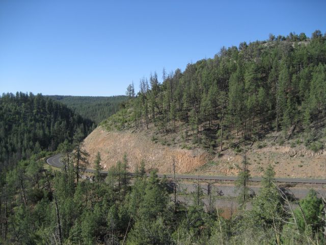
It would seem that there is some bridge work being done somewhere up the road. We decide to see if we can find a local that can give us a bit more info before we spend the time to ride in and possibly have to turn around. So we head back towards town a mile or two to find the local gas station, which is just a big tank above ground next to some pumps. Inside we ask the lady behind the counter if she knows what the scoop is on the road. She informs us that it is open until you reach the campground at Haigler Creek. The campground and the road are closed for upgrades. Well... perhaps if all they are doing is putting a bridge over a creek we can squeeze by on the side? "Can't hurt to try," she replies. After a top off of gas, we head back to see what awaits us.

:tab The road is nice and wide, being fairly well maintained hard packed gravel/dirt. It is soon rising and falling, twisting and turning through the woods. Casey has me running point with the GPS, which is cool because it gives me a break from the dust and a clear view ahead. It does not take long before we reach the campground and the "Closed" signs. We skirt around those and go a little further.

The spot where the new bridge is being built
IMG_0906.JPG


:tab We walk around the construction equipment to have a look. There are several construction guys hanging out. The tall fat one gets a little peeved that we are there and starts lecturing us about fines and such. The creek is shallow and narrow, easily crossable upstream or downstream of their work. I explain our dilemma regarding the extra miles if we have to find away around. No dice, the big guy is having none of it and his tone gets more hostile :roll: Not wanting to start an incident, we decide to back track. Looking at the GPS, there are a few "roads" that loop around this spot, but according to the topo contours, it would be a wild ride! Well... how bad can it be?

Heading back to look for the cut off for the side roads
IMG_0908.JPG


I'm loving it!
IMG_0909.JPG


:tab Well, I am scanning for the road while trying to watch the GPS and I still manage to ride past where it should be. So I turn around again and watch REAL carefully. In fact, I have to stop and look for a moment when I reach the spot where the GPS says the road should be... and there they are... two faint trails running up a steep narrow gully :wary: It might not be as hot as the desert, but if we get stuck up in there, it is obvious there will be NO ONE coming by to offer assistance. At this point, I decide to just pull up in front of the house on the other side of the road to see if anyone is home. Local advice is usually the best.

:tab The dogs alert as soon as I park in front of the house. That saves me the trouble of knocking on the door :lol2: Sure enough, before I can even finish getting my helmet off, the front door opens and a friendly fellow walks out. I explain our situation and he invites me inside, saying he has a map and can show me where to go. The house smells of fresh pancakes and coffee :drool: It seems he, his wife, and some visiting relatives have just finished breakfast. She offers me some coffee, but I have long since kicked that habit and substituted another (Cokes :doh:). The husband disappears for a moment and then comes back with a big rolled up piece of paper...

This is Bill, and he knows every goat trail in these parts!
IMG_0910.JPG


:tab I indicate the trail we had been contemplating and Bill laughs. It seems they have been back up in that area on their ATV's but it eventually gets too rough even for the ATV's to get through. Getting through there on the bikes might be possible, but it would certainly be a major undertaking. Okay... "But I have a better route!" And so bill begins to explain, "You cross this creek, run up this little hill, when you reach this clearing there will be a small intersection, hang right an run up another hill... and you'll eventually come out just on the other side of the construction!" Sweet!! He assures me that they take their ATV's this way all the time and that the bike should easily be able to make the trek.

I snap a shot of the map just in case... Hi res digital cameras rock!
IMG_0911.JPG


:tab I thank Bill and head back outside to share the good news with Casey and John. Here we are, only a few miles into the day and already we are off on a new adventure :rider: 
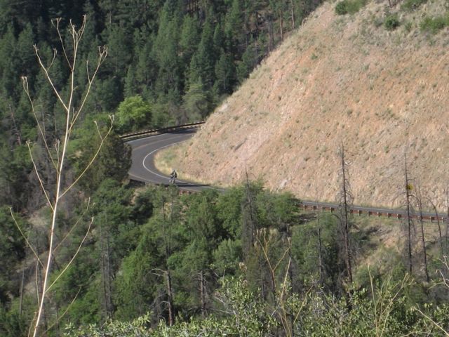
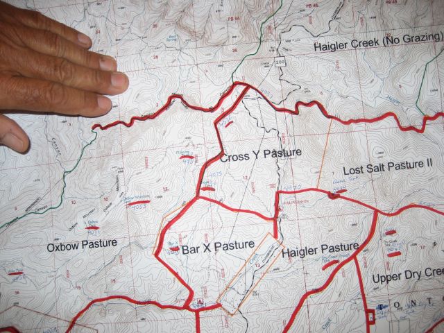
Sure enough, a few miles back up the road, we find the turn, head down across a creek, up a little hill to the clearing, hang a right and then things get fun! You can see the four way intersection just below the X in the Bar X Pasture on the map. The trail climbs and twists its way among some little peaks, through some dense woods, runs North almost to the tip of the Cross Y Pasture and then bends East back to the main road. It is a blast!

A flat wide section of our wonderful detour
IMG_0912.JPG


:tab All too soon the fun is over and we pop out back on the main road just like Bill said we would, a little bit North of the construction. It is tempting to trot back down the road to say "Hi" to the worker guys :lol2: 
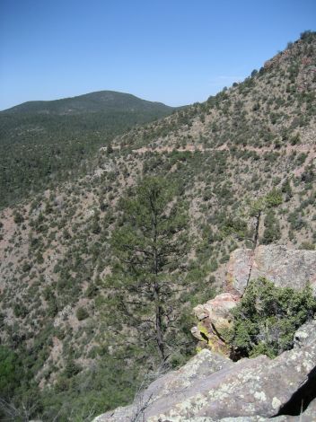
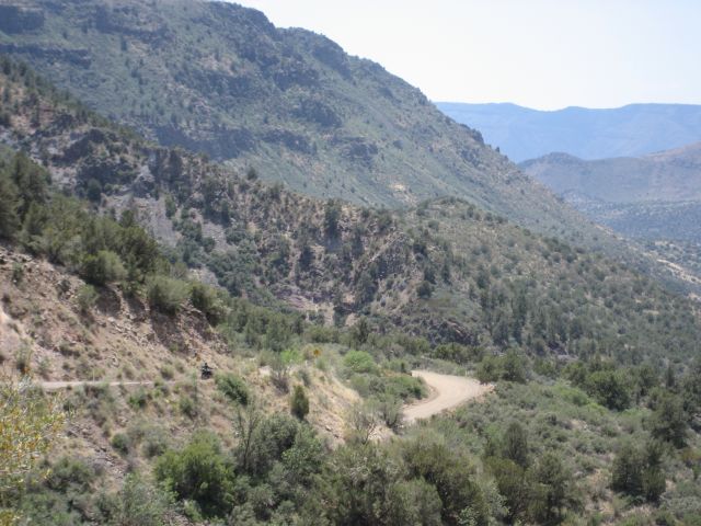
Well, that would be real mature... So we just get back to our riding and are soon climbing up out of the creek valley onto a fantastic ridge, climbing from 5500 to 6500 feet in a few minutes. Near Turkey Peak, we stop for pictures looking back down into the valley below.
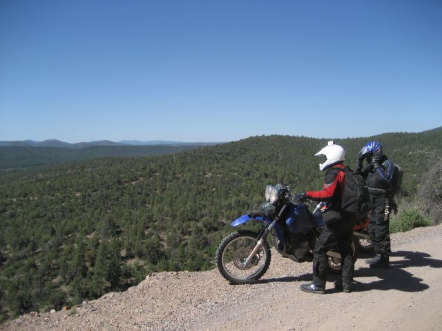
IMG_0913.JPG


You can see the road going back up the valley in the center of the picture before it veers right off the edge of the picture
IMG_0914.JPG


IMG_0915.JPG


You don't want to blow a corner here... :-|
IMG_0916.JPG


IMG_0917.JPG


IMG_0918.JPG


Panorama: We came up the right valley and eventually hiked over to the peak jutting out on the left. The line of peaks in the far distance on the right are were we came in last night.
fisherman_point_small.jpg


Another gratuitous KLR shot :trust:
IMG_0925.JPG


[Gotta work again... :doh: Back later...]


:tab I cruise on up the road a bit and see a nice spot to pull over in the shade to take a break. There is a trail leading out from the pull off area to a precipice maybe 75 yards away. Looks interesting...
 
Saturday, 5/26
Locked gates and sheer exhaustion.

My eyes popped open at about 4:30am and I laid awake until there was enough light to get up and get ready for my short hike to some 900 year old Verde Hohokam cliff dwellings hidden nearby. I hoped to arrive in time to photograph them before the harsh light of the direct sun made them difficult to shoot. I grabbed my backpack and tripod and took off in search of the faint trail that led the way over the saddle. Once I arrived at the site, I remembered part of what made the ruins so difficult to shoot the last time I was here... there was no place to stand or set-up, due to the steep slope and terrain. I did my best with what I had, and sat in the east-facing cliff for a little while to enjoy the outstanding scenery that surrounded me.

_DSC3253.jpg

_DSC3253.jpg


_DSC3295.jpg


_DSC3304.jpg


_DSC3337.jpg


_DSC3306.jpg


_DSC3316.jpg


_DSC3332.jpg


_DSC3324.jpg


Back at the camp, forgetting once again to remove the cover on my airbox, I loaded up and gave the map another once-over. My plan was to take the backroad into the once ghost town of Jerome. From Jerome I'd climb out on the twisty Hwy 89, then turn left for a series of roads/trails that I'd been curious about since I lived in Arizona, but never got around to exploring. This route would dump me out east of Dewey, then I'd make my way west to Prescott to meet Scott and John. At this point, provided the footpeg was back in place, we should have plenty of time to make it back to Phoenix via Senator 'Highway' and the Crown King road. It was a difficult decision, but after our experience the first day, I decided to spare Scott the pain of the incredibly scenic but somewhat technical Crown King trail :tears: .

This was one of those mornings that I was 'on', and my pace grew faster and faster as I worked my way back out FR181. Before long I was pushing the loaded DR harder than I had ridden in years, and finessing the testy throttle actually seemed to make me ride smoother than usual. Barreling down the last straight of the rough road, I didn't bother slowing down for the transition onto Perkinsville road. I made good time by the time I reached the more dangerous, more heavily traveled shelf road portion of the Jerome back way, and slowed down to an easy pace for the remaining 18 mile ride into Jerome.

Jerome is a unique place. Once an old mining town, it clings to the side of a mountain as Highway 89 switchbacks through it's crumbling interior. The old buildings appear tired and lifeless, despite the bustling new life that has fairly recently been breathed into the town. Old hospitals and schools are now hotels, and bars and restaurants abound. I wish I had time to hang out a while, maybe grab breakfast, but alas, I have a schedule to keep, and unknown riding awaits.

Jerome, from where I stopped…
DSCN2438.jpg


I sputter and spit west, climbing into what perhaps the best 12 mile stretch of paved nirvana in Arizona. Oh, how I wished for a properly running bike and fully inflated tires... Still thoroughly enjoyable though.

DSCN2440.jpg


The road eventually straightens out and I begin my search for FR151 to my left. Once upon it, I thump south on what begins as a well maintained road. After a few miles, the road forks; the maintained portion going to the left with a sign for a boy’s camp, and my road, to the right… the maintenance obviously stopping here. I climb the trail to the right, which soon offers views toward Prescott, Prescott Valley and the mountains beyond.

DSCN2443.jpg


DSCN2444.jpg


My pace increased as the trail became rougher; I had a schedule to keep, so I had to compensate for the conditions… soon the trail became badly eroded with wheel swallowing canyons and large, sharp boulders. Climbs and descents were many; steep, badly eroded with loose rocks, and the worst part of all… with washed out ditches at the bottom, just large enough to grab hold of a front wheel, catapulting a rider against the opposing face. The difficult part was controlling the speed of the loaded beast downhill, without sliding, so that I could come to a complete stop, drop the front wheel into the ditch, throttle out with enough momentum to carry the back wheel across and get a good launch for the scramble to the top. Luckily I had the weight on the back of my bike to aid my handicapped right wrist in lifting the front wheel. Of course, even though I noticed that there didn’t appear to be much traffic on this trail, it never occurred to me to consider why… After many miles of this abuse, the road finally leveled out and turned toward the valley, my target. I passed an intersection, veering right and came to a gate. It isn’t unusual to pass through gates around here, but this one was different than the others; it was locked… twice :doh: . I dismounted and stared into the valley at the town that was only a couple more miles away, thinking to myself that I could not turn back.

DSCN2445.jpg


I had an hour before noon when I told the guys I’d meet them, and it would take me a couple to go back the way I came and ride the pavement around to the north side of Prescott. Plus, at this point I was getting tired from my morning of spirited riding, and wanted to be done with it. I was hungry, my cartilage-free wrist was finally beginning to hurt pretty badly and all of my standing was really beginning to aggravate the fibromatosis in my feet. I considered the wire-cutters on my Schrade multitool, but decided I’d save that as a last resort, besides, I had no idea what I’d find at the end… a rancher’s back yard perhaps? Consulting the map, I find a couple of other options, that while they go in a less productive direction, might offer me a way out, and with fewer miles than returning the way I came. If any of these work, I can still make my noon meeting time. I make haste back to the intersection and turn east. After blazing a couple of miles, I come upon a forest service sign: “No Outlet, road ends at locked gate” :argh: . Sheesh… you’ve got to be kidding me! Why put the sign at the end of the road :brainsnap ?? Had it been at the beginning I never would have come this way to begin with! I consult the map again, and if I’m reading it correctly, it indicates another trail a short distance back that heads south. I double back (which I always hate doing) and begin my search for the trail. I didn’t have to search long before I was on my way down a faint, lose, rocky double track trail that followed a ridge for a short distance before dropping down the rocky hill. As it fallowed the ridge, the trail would drop steeply for a short distance, then level out some, then drop again, etc. I skipped across the jagged, copper colored rocks, thinking to myself, “man, I hope I don’t have to ride back up these hills”, then came sliding to a stop… the next drop was long and STEEP, comprised completely of lose, jagged boulders. This was a decision point; if I continue, I have to commit, because I am NOT climbing back up this hill… I decide that I’m not ready for this just yet, as I didn’t even go all the way to the second gate mentioned by the sign… what if it’s open? I work hard to get the bike turned around on the narrow, boulder strewn trail and begin roosting rocks back to the main trail. At this point I am in race-mode, despite the heavily laden dual sport, and intensely focused on getting the heck out of this trap. I blew past the sign, feeling a bit of an anger rush at the sight of the white blur on a pole. Some distance later I find myself sliding up to gate number 2... Locked. The fence was a very tall, wire grid type; the owner obviously was serious about keeping trespassers of all species out, or perhaps something in… as I stood with my back to the gate pondering my next move, looked to my right, across a large, canyon-like ditch, and spotted a strip of gravel… a road, a maintained road! That had to mean a way out, and there had to be a way to get to it. I turned back, looking for some sort of trail that might take me to the heavenly strip of gravel. I eventually came upon a badly eroded opening in the scruffy vegetation, in a low area that could easily enter the ditch. I eagerly turned into it, hoping it would be my saving trail… and eventually popped out onto the road! I was off in a cloud of dust, climbing to the top of a large hill. Once at the top, I saw that I would soon be faced with a decision, as the road I was on was part of a network. I began to think that maybe I was on some sort of quarry property, and continued in the most southerly direction possible. If this is a mine or quarry operation, I don’t care. I’ll pass through the front entrance if I have to, leaving those who care coughing in my dust. A couple of more turns and I find myself at the end of the road, at the top of a hill.. And at the intersection of a dirt neighborhood road. One little problem… there’s a locked cable. Turns out there way just enough slack in the cable to squeeze the bike under, and I was on my way through a new maze, but at least a civilized maze.

Eventually I popped out on Hwy 169 and high-tailed it west as fast as the gasping DR could go. The traffic was horrible, and my impatience sent me weaving thorough the sea of the cages with their zombie-like pilots. My goal was to reach fast food in Prescott proper, and try to contact Scott while I have a much needed rest. I rolled into Jack in the Box right at noon, slid off of the dirty DR, and staggered, exhausted, into the ‘Box. I sat down in the back corner and started peeling off gear. It was only noon, and I had already experienced a full, hard day of riding and adventure. After inhaling a Jumbo Jack and sucking down a coke and a couple of lemonades, I pulled out the phone and called Scott. They were downtown, hanging out at a festival on the county square. The KLR was fixed, and Scott told me where to find them. The only problem was that I did not want to move, at all. I had no desire to climb back on the bike. After extending my rest a bit, I forced myself onto my feet, and wandered into the parking lot.

Once into town, I passed the square and found the bikes parked along the side of the street. The DR joined them and with a slight limp I slowly made my way toward the festivities. John and Scott appeared in the sea of people, heading my direction, so I leaned against a nearby window sill. Back on the bikes, we went to refill on gas and water before moving out Senator Highway.

Senator “Highway” is a mostly dirt road that wanders through the Bradshaw mountains and connects Prescott with Crown King, an old mining town that barely survives as an off-roaders turn-around point and watering hole. The road is an old pioneer route that took its name after the Senator mine that was active in the 1800’s, and is anything but a highway... The winding 35 mile road begins paved, then turns to well maintained dirt, then eventually becomes a high clearance road the rest of the way to Crown King.

I was feeling pretty bad at first, so I told the guys to go ahead while I sit back and veg a while. After some time I found myself back in the middle, winding through the somewhat high traffic road (for an unimproved dirt road). At each blind hairpin each rider would go wide, looking around the bend for any oncoming pick-ups or quads. I watched Scott go around one turn, wide as usual, then suddenly a black dodge truck appeared :eek: , sliding to a stop just before the drop into the trees… From my perspective, Scott appeared to have been hit as I thought I saw the back of his bike kick to the side. My adrenaline dropped as I went into ’oh crap’ mode. I came around the front of the truck, the driver of which actually appeared irritated, and found Scott to be okay, just a bit shaken. He said that the truck didn’t quite hit him, just came darn close. We went on our way, now even more careful than before.

DSCN2453.jpg


DSCN2459.jpg


DSCN2461.jpg


DSCN2462.jpg


As we approached Crown King the campers became plentiful, with an abundance of quads and jeeps. It was a holiday weekend, and the banjos were playing :-P . I pointed out the entrance the Crown King trail that I had reluctantly cut from the trip.

Once through Crown King, we descended back into the desert via the Crown King road. Our ride down was interrupted by a line of emergency vehicles, which were tending to an injured quad rider. We stood in the road for a while, chatting with one of the emergency personnel until the big guy was loaded into an ambulance. We managed to get ahead of the ambulance when it pulled over briefly, and made our way out the road through Bumble Bee to the freeway, where our ride basically ended, and about 70 miles of droning paved torture began.

It was good to be back at the truck. I ran the guys around town gathering some of mine and Dawn’s favorite food to take home, then we returned to the diving chick motel…
 
Last edited:
:tab I cruise on up the road a bit and see a nice spot to pull over in the shade to take a break. There is a trail leading out from the pull off area to a precipice maybe 75 yards away. Looks interesting...

I'm beginning to think you fell off of the precipice...

So then what? Did you see any giant baby elk?
 
Yeah.. yeah... :nana:

You just wait until you have that second kid running around the house... :-P
 
Yea, Yea, just wait until you have a job where you have to work :lol2: Now get off the porch and get to writing :-P

Unfortunately, those days have been gone since right about the time you left here... :doh: I can't remember the last time we sat around on the back deck... Odds are it will only get worse for the next week or so because Dad just left for a week of vacation and we are already getting slammed...
 
Thursday 5/24: Continued...

:tab So anyway, we're standing on this precipice looking back down the valley the direction from which we came. Bubbling up on the breeze from down below is the sound of Haigler Creek tumbling down into the valley over the many rocks that have long since fallen away from our perch on high. No mutant baby elks to be seen anywhere... :-P The air is crisp, dry and cool. It just feels so refreshing against my skin, unlike the thick clingy air in the deep woods of East Texas back home.

The road up out of the valley
IMG_0926.JPG


Casey pondering the view with an eye towards taking the perfect picture... I just snap away relentlessly... :lol2: That is the road out just over his head.
IMG_0928.JPG


Gotta watch where we're walking or it is a long way down!
IMG_0929.JPG


The top of the tree in the center is about even with our feet
IMG_0930.JPG


John and Casey scoping out great camping spots down by the creek
IMG_0931.JPG


So this rock has been here a LONG time... I wonder just how many more pounds would be enough to make it teeter off the edge... :eek:
IMG_0932.JPG


IMG_0934.JPG


Looking back up the creek valley, very rocky and rugged!
IMG_0935.JPG


Quite a few trees out here have been burned... I wonder if it is lightning related since we are so high up and there is not much evidence of burns lower down?
IMG_0936.JPG


IMG_0937.JPG


:tab After our break, we start climbing up out of the valley again. The road is great. The weather is great. The bike is running great. I am not at work. My pager is at home. The cell phone is turned off. Man... I need to do this more often! After passing by Turkey Peak, the road drops down into a shallow valley and runs back to the Northwest. We soon reach Hwy 260 where we stop so Casey can do some route work in his head and consult his maps. After a few minutes of baking in the sun, we decide to head West and pick up another dirt road oddly named "Control Road". It cuts over from Hwy 260, North of Payson and comes out over on Hwy 87 just South of Pine. Not only should it be fun, but it will save us some time in connecting to our next dirt road.

:tab I take point, enjoying the smooth pavement and highway speeds. It is only a few miles to our turn off but I like being on the pavement for a bit. It is a nice time to relax, take in more of the scenery, and enjoy the wind blowing through the mesh gear. Central Arizona is simply beautiful! It doesn't hurt that Hwy 260 is a really nice ride too! We soon reach our turn and head back onto the gravel. The road is wide and relatively smooth, not too dusty, and is soon wandering through the woods. I love it.

A small sample of the Control Road
IMG_0938.JPG


John eyeballing a little trail that runs up the hill from the road...
IMG_0939.JPG


:tab It does not take long before we reach Hwy 87 and then we head up into the small town of Pine. We do a run up the center of town to take it all in. On the North side of town we pull over to top off the bikes with gas. I spotted a nice looking little 50's cafe back down the road and we agree to try it out. The parking lot is pretty full so it can't be too bad ;-) Looking at the age of the average patron, I think the idea of a 50's style cafe here was a pretty shrewd business move :-P

Casey tries to decide what to eat...
IMG_0940.JPG


:tab The food and service are pretty good. Casey gets a HUGE chili dog that takes up the whole plate... :uhoh: 
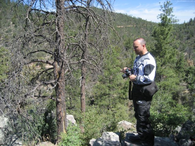
No way I could eat that and then get back on a bike! Thank goodness I have been taking point today, hopefully that won't change after lunch :wary: My cheeseburger really hits the spot! However, it is the Coke that really makes my day... Yes... I am an addict :doh: Stuffed, we head back outside to resume our journey.
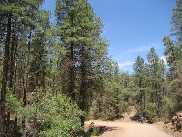
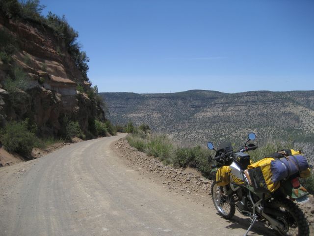
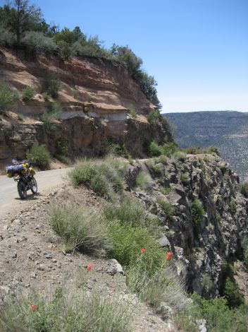
Looks real 50's on the outside eh? :whatever:
IMG_0941.JPG


The friendly old keeper of the porch really likes a good belly rubbing!
IMG_0942.JPG


:tab As we head out of the parking lot, Casey takes point :twitch: I'll have to hang back a little... :trust: We head up the highway a few more miles to another tiny little touristy town, Strawberry, where we cut West to find the Fossil Creek Rd. As we leave Strawberry, we are right around 6000 feet in elevation. The road starts down into a valley and slowly drops in elevation. It does not take long for things to get interesting!

That little dot above the trees at the base of the road is John or Casey, hard to tell from here... :scratch:
IMG_0943.JPG


Not much better here... notice the locked gate!! :doh: :tears:
IMG_0944.JPG


:tab When I catch up to the others, they are stopped at a sharp curve that bends the road around onto the edge of a deep canyon. I am a little disappointed that we were not going up the road with the locked gate (not that I want to go around the gate, but that there was a locked gate there to begin with ;-)). However, this road looks promising! :trust:

IMG_0945.JPG


See how steep that wall on the left is...? Well... it is just as steep off to the right immediately beyond that pile of gravel on the edge of the road :eek:
IMG_0946.JPG


According to Casey, these barricades are recent additions to this road
IMG_0947.JPG


A better view of the drop... don't want to blow a corner here!!
IMG_0948.JPG


Road is the ledge on left side
IMG_0949.JPG


:tab The drop looks to be several hundred feet easily and that is just to the first spot where you'd HIT on the way down. It is quite a bit farther all the way down to the bottom! Carefully looking over the ledge, it would appear that the barricades should have been put up a long time ago :-| If one was not familiar with the road, this curve sneaks up on you because it is at the end of a straight section and down behind a slight crest in the road!

Apparently, even the locals had trouble with it...
IMG_0950.JPG


Apparently, they have been having trouble with it for quite some time! :doh:
IMG_0951.JPG


:tab Standing here looking at the assortment of vehicles at the bottom is kind of strange. It is a LONG way down and there would be far too much time to ponder one's fate... I will be riding VERY carefully while we are on this road! As we are mulling around taking pictures, the local FedEx delivery guy roars by in a cloud of dust. At his pace, I don't think getting stuck behind him in his dust will be a problem! I take point just so I can get ahead to stop for more pictures. I have a feeling this road will have plenty of opportunities!

John posing for me to help give a sense of scale
IMG_0952.JPG


IMG_0953.JPG


He's that dot above the center of the second gravel slide from the left
IMG_0954.JPG


:tab Off in the distance I see the FedEx guy's plume of dust and his truck rounding one of the many bends. As we ride on, the road starts a gentle descent down into the valley. The nasty corner was at about 5400 feet. The bottom of the valley looks to be at least a thousand feet down from that point. The farther we go, the steeper the descent becomes. Eventually, we reach some switchbacks and begin to descend pretty fast!

John heading for the first switchback
IMG_0955.JPG


John is a big guy, but you'd never guess it from this pic! :lol2:
IMG_0956.JPG


Or this one!
IMG_0957.JPG


I've almost got the camera pointing straight down at this point
IMG_0958.JPG


IMG_0959.JPG


IMG_0960.JPG


:tab After taking my pics, I set out to catch up to the other guys. When I reach the bottom, the road flattens out and runs along the side of Fossil Creek. We've dropped to about 3500 feet from 5400 feet! I find Casey and John on the side of the road chatting with the FedEx guy. He's already made his delivery and is headed back the way he came! I pull up to find Casey and him carrying on a confused conversation, hehe. Apparently, between Casey having his helmet on and the noise of the truck, neither of them can hear each other and both are a little confused by each other's responses :lol2: I pull right up next to the guy and just ask him politely, "Are you asking us for info or offering us info?" He replies, "I'm offering info if you want it!" Cool! I listen as he tells us about some camping opportunities. We then thank him and get back to riding. All along the side of the road, there are little side trails that run down to the creek a few yards distant. There are cars and trucks tucked into nearly every one of them. We reach a spot where the road crosses the creek and Casey pulls us over for a stop. Time for a break.

Heading down to the creek for a dip!
IMG_0961.JPG


Really have to watch your step...
IMG_0962.JPG


The bridge over the creek with a nice shady spot underneath... already occupied :doh:
IMG_0963.JPG


Looking upstream from our spot
IMG_0964.JPG


Not looking to good for dipping this way...
IMG_0965.JPG


Looking better back towards the bridge! See it?
IMG_0966.JPG


Casey and John concur :trust:
IMG_0967.JPG


Aaahhhhh.....
IMG_0968.JPG


John really gets into his river dipping :-P
IMG_0969.JPG


Casey is trying to decide if he can tolerate the cold water and the nice breeze that makes wet clothes feel even colder!
IMG_0970.JPG


John again
IMG_0971.JPG


Now they are hassling me about getting in...
IMG_0972.JPG


Resistance is futile... :borg:
IMG_0973.JPG


:tab I carefully make my way down into the water... BRRRrrrr!!! Aaahhhh!! Ohhhhh!! That is a bit chilly there!! :huh2: Aaahhh!!! Much better now... I find me a good rock to sit on and enjoy the cool feeling of the water. Small perch are tickling me by nibbling on my toes and leg. In a few minutes, the shock of the coldness wears off and I am used to the temperature. Man... this is just what I needed!! While hanging out, John realizes he has cut his foot on something. It is not serious, but it does seem to be bleeding pretty good. As we climb out, he notices blood scattered about all over the rocks where he was taking off his gear and getting in the water. He follows it back to the culprit... a piece of litter from some careless twit that was here before us
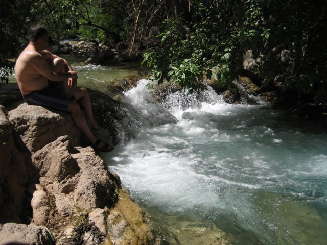
 :doh: :argh:

:tab I get my gear back on and then head towards the bridge. I always like the way my socks and boots feel after my feet get a good soaking in cold water. I have done it on many other rides as well. However, high in the Rockies of Colorado, it is ONLY my feet that get dunked and even then only for a minute or so before I simply can't take the frigid temperature of the snow melt water! Right now, my feet have that soft warm fuzzy feeling like my bed in the morning when I am at that perfect temperature that makes getting out of bed so !#$%^& hard :roll:

A small water fall just as the creek goes under the bridge
IMG_0974.JPG


It gets deep and nice on the far side of the bridge!
IMG_0975.JPG


IMG_0976.JPG


:tab Yes, I could really get used to being able to come to a place like this fairly often and just hanging out, relaxing, and forgetting about all the worries of the world. Alas, we must move on...

Soaked head to toe... but loving it!
IMG_0977.JPG


:tab As we leave the creek behind us, the road once again starts to get fun! In short order we are climbing up out of the valley on a pretty steep road. The road has some pretty harsh washboard though and it is really beating me good at the pace Casey is running, maybe 25 mph or so.

The view from behind...
IMG_0978.JPG


IMG_0979.JPG


:tab According to the GPS, we have a pretty good way to go before we reach another intersection. I catch up to John and Casey pretty quick. John waves me around and I settle in behind Casey. Somewhere around Cimmaron Creek, I just can't take it any more. The road has gotten pretty bad. For me, it is much better at about 35-40mph, so I move around Casey and set off. After passing through about 4500 feet, the road begins a fantastic twisty descent down through Hackberry Canyon. The road is awesome. It is one of those annoying times on the bike where I am totally in the groove, having a blast, and I just don't want to stop to take pics! However, I know that this is the best place to take pics :doh: Surely you understand my dilemma :-P Ride it is then... and the KLR is all for it!! The gravel rolls and crunches under my tires as I grind into the corners and then spray rocks coming out. At several high spots, I wait until I catch a view of the others and then take off again. Other than a truck we passed going the other way back by the creek, the road has been deserted.

:tab Eventually, the road begins to straighten out and the valley opens up, getting very wide. The fun is about to end as I can see the highway in the distance. I pull up to an overlook and take in the view looking back up the canyon. After a few minutes I see the dust from Casey and John come around a corner. We're pretty close to Camp Verde, which I think is where Casey is planning to find a place to camp. After they reach the overlook, we consult the GPS. Casey shows me where we are trying to go and I take the lead again. After getting a bit confused about which way I am supposed to go (I forgot to zoom out the GPS to get the big picture :doh:) I turn around a few hundred yards down the road and get us going the right direction :oops: Now we're on Hwy 260 heading into Camp Verde...

[Time for bed... more later!]
 
Great Pics!!....a really cool adventure:zen:
 
After reading this post in one sitting, I think I'll trade my little Ninja in on a pocket bike instead of a 2008 KLR!

I'm familiar with all of northern New Mexico and most of northern Arizona down to Sedona, you can have the desert riding. I like trees and mountains.

I did learn a few good tips. Now I know another use for a Crown Royal bag - pot holder! ;-)

Sounded like an interesting trip. :rider:
 
Thursday 5/24: Continued...
We head up the highway a few more miles to another tiny little touristy town, Strawberry, where we cut West to find the Fossil Creek Rd. As we leave Strawberry, we are right around 6000 feet in elevation. The road starts down into a valley and slowly drops in elevation. It does not take long for things to get interesting!

We love Strawberry! We stayed at a rustic A Cabin there so we could play in the snow up on the Mogollon Rim. Wonderful country.

That is great camping country. We did Cub and Boy Scout camping on the Rim and loved it. (Down to 17 F one night at Crook Campground near Woods Canyon Lake in October, though).

I'm jealous and missing Arizona.


Lee
In Sugar Land
 
:tab Lee, our route was supposed to run along the top of the rim, but a fire prior to our leaving had that area closed down. Casey was most distraught about this, perhaps more than just about anything else!
 
:tab Lee, our route was supposed to run along the top of the rim, but a fire prior to our leaving had that area closed down. Casey was most distraught about this, perhaps more than just about anything else!

Aw, bummer! Forest fires are a constant problem there. What do you think the "Control" in Control Road is about, eh?

Ask the locals about what they think of "environmentalists" who won't let the Forest Service remove all the trees killed by pine bark beetles, if you ever go back (but be prepared for an ear full).

We hiked Horton Creek with Boy Scouts (trail head starts near the Tonto Trout Hatchery, east of Payson) and it was awesome. Fresh, potable water coming out of the side of the mountain.

Lee
 
:tab Lee, our route was supposed to run along the top of the rim, but a fire prior to our leaving had that area closed down. Casey was most distraught about this, perhaps more than just about anything else!
Yea, I was definitely pretty disappointed about that. However, I think that what I was most disappointed about was missing what should've been the 1st 2 days; the connection between Salt River Canyon and the Sierra Anchas, and camping at Devil's Chasm on Cherry Creek for a couple of nights. Those are 2 beautiful areas, and I'd imagine the transition between them would be as well.

I was also really disappointed about missing the Crown King trail, the guys would have really liked that one if we could've done it without being pressed for time.
 
This report makes me want a bike even more!!! Oh when will the planets align? :-(


Scott, you and Casey look the same. I could easily pick you out of a line up.
 
This report makes me want a bike even more!!! Oh when will the planets align? :-(


Scott, you and Casey look the same. I could easily pick you out of a line up.


1. When your girls are out of college... maybe... :-P

2. I age like a fine wine, getting sweeter and more full bodied with time :doh:
 
Scott it's only noon....what are you doing up so early?

btw, it looks like your letting one rip in that pic ha ha
 
Casey, he meant the same as we looked before... not the same as each other. I am much cuter :-P (see above :trust:)

Chris, Dad is on vacation this week. 8:00am every day... :suicide: Besides, the days of sleeping until noon are long gone. Daniel is up around 6:00am everyday and even if I stay in bed, there is little sleeping going on after that...

Chris? :eek2: Where the heck did you come from? Didn't know that was you...

This report makes me want a bike even more!!! Oh when will the planets align?
Hey, I gave you a Suzuki TM250, where is it?! No excuses :-P


Scott, you and Casey look the same. I could easily pick you out of a line up.
I thought that seemed like a terribly strange comment... makes sense now :lol:
 
well i have to say i wish you started riding sooner. Cindy said a couple of years ago, that i could have a bike before i turn 30. because "thats when Scott started riding" so now i wait, for another 1-1 1/2 years. i am seriously thinking more along the lines of a DS instead of going down the Nighthawk rode. but ultimatly it will be whatever i can afford. which right now is not even a cycle trader. its good to see ya'll had fun and that ya'll gained a lot of experince and not a lot of damage (personal or property). Good to see you again Casey!

ps my girls are the same way.but they let me sleep in till 9:30 on the weekend. guess that makes me lucky


the 250 went to my budy in Huntsville. he got it running but still not quite rideable. if it's any concelation i learned a lot about it and spend many nights and weekends playing with it. the memory of getting the trailer over to my house is still fresh in my mind. oh, college
 
Thursday 5/24: Continued... again...

:tab It is only a few miles into the edge of Camp Verde. I turn off onto another gravel road that shows to skirt along the East side of town over to the Beaver Creek campground. It is a wide gravel road, more washboard, and the KLR loves it! I settle in to a nice pace around 55-60 mph and make some serious dust! The road occasionally crests a gentle hill and runs straight off into the distance to crest another hill. There is very little traffic. It does not take long before I reach the turn to head down to the campground so I pull up and wait for Casey and John. Off to the East I see narrow canyons crawling up between numerous peaks. The map shows a LOT of trails that direction... One week out here just isn't enough!!

:tab After we are regrouped, we head down into the camping area to see what the situation is. The situation is... not good... :doh: 
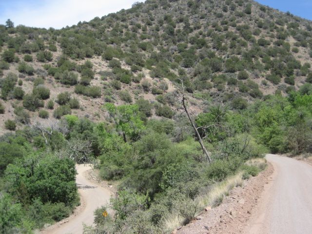
The campground is full. Well, we are not set on doing the campground thing and would actually prefer a more isolated location. So we decide to scoot down the road a bit to see if we can find another spot showing on the map as being not too far from here. The road out to the remote area is a hoot. It is rough with a lot of wash outs, huge potholes, big rocks, a nice descent, and then eventually we drop back down in to the creek valley and find a primitive camping area. The map shows we have arrived at Lawrence Crossing.

:tab We park the bikes and take a look around. It would appear that motorized vehicles are not supposed to venture into the camping area. It would also appear that a lot of horses are ridden around here... :uhoh: I make a mental note to pay more attention to where I step. We hike a short ways down toward the creek. There are some nice camping spots but it kind of smells like a barn. The "crossing" is a crossing in name only. Whatever road may have existed here and on the other side of the creek has long since been reclaimed by the trees. Still, it is pretty here with the light reflecting off the rippling water, the sounds of the water making its way in and around all the rocks, and the gnats... If we do camp here, we will have to carry the gear a pretty good ways from the bikes. I can't quite place my finger on it, but thinking of camping here just doesn't sit well with me and it is a pretty strong feeling. Bad vibes... I don't know. Maybe it is some kind of ancient sacred Indian site :shrug: Anyway, we head back to the bikes and ride back out to the main road. We've decided to go to the Ranger station on the other side of the main road and talk to them to see what our options in the area might be.

:tab As we pull up to the Ranger station, we notice the parking lot is mostly empty and there are Rangers getting ready to drive away. I glance down at the GPS... 4:30pm... Oh crud! I should have known. I used to work for the Federal Government and trying to get anything done after 4:30pm was nigh on impossible even though officially we were supposed to be on the clock until 5:00pm. I check with one of the Rangers in the parking lot and she assures me the office is still open. So we head in to see what we can learn.

:tab Inside we find a nice little Ranger lady willing to tolerate our questions. Casey and John seem to have things in hand with her and discussing where our options might lie, so I peek around the office a bit. Seems like this is a pretty good size station with quite a few offices. There is TONS of stuff about forest fires, pictures of past fires, maps everywhere, and then the signs. If you have ever been in any kind of government office, you know what I mean. There are signs ALL over the place telling you what your rights are, what nitpicky law or rule governs whether or not you should be standing here reading the signs, what the government will do to you if you should fail to comply with the endless and often incomprehensible rules, blah blah blah...

:tab If there is ONE lesson I have learned from setting up and running a large forum, it is that people are loathe to read, comprehend, and follow rules. It is a serious mistake to think that simply making up a bunch of clever rules will actually create the neat and tidy world envisioned in your head. Ain't gonna happen :whatever: So you have to stick with the basics! Be nice. Don't steal. Don't kill each other. You know, basically the stuff of the Ten Commandments. After that, most folks are pretty much going to do what they want regardless of an endless stream of new rules/laws fine tunning this imaginary world for which the rule makers aim. Oh well...

:tab It seems that Memorial day weekend, even on Thursday, is not a good time to be looking for a place to camp in this area. The Ranger informs us that every campground for miles is booked. However, there is this one, on the other side of the interstate and not too far away... She offers to call them and see if they have any openings. They do and she asks them to hold two sites for us. We thank her and head back to the bikes. It's hot. Being inside I had cooled off. Still, it only takes a minute before I am right back to being just as hot now as I was before we went inside. It's a dry heat though :trust: Back on the bikes, I take point and enjoy the wind flowing through the mesh riding gear, sweeping away the sweat and cooling me quite a bit.

:tab Well... looks like it is all pavement from here on out today. We hit I-17 and head South in the fast moving traffic. Casey's bike seems to be running okay even though we are just under 4000 feet. I was worried he might not be able to run 70mph. At the very next exit we hop off the interstate and pick up Cornville Road to the West. Then we head North on Page Springs road a few miles before spotting the sign for the campground. We pull in and they are expecting us in the office. Casey has a minor stroke over the price, something about NEVER having paid so much to camp anywhere in Arizona... Well, to be fair, it was a lot more than I would have expected, but this is a private campground not usually open to the public, so they don't usually cater to grubby looking guys on dirt bikes ;-)

:tab The lady in the office is real nice. She takes us all for a ride on her golf cart to go scope out the potential sites. We tell her we want something as close to the river as possible. "No problem," she replies. She soon has us right next to the river under some huge Cottonwood trees, right next to the only swimming hole spot in the campground. Best of all, the site is fairly isolated and we don't have any other people right on top of us. With our spot picked out, we head back to the office to get the bikes.

:tab One might think I would have learned by now that you never let your guard down when you are on the bike until you have the engine off, the bike on the side stand, and you are walking away. As I am pulling into the camping area, I hit a deep loose sandy spot that I did not notice when we were in the golf cart! The bike swaps ends momentarily and then I get back on firm ground... whew! That would have been embarrassing!! I circle around the edge of the site and pull up over next to the picnic table on a spot that looks good. I kill the engine, put the stand down, test to see if the ground feels firm enough to hold the bike, and dismount... Well, at least that is how it was supposed to happen :argh: As I am lifting my leg over the bike to dismount, the bike follows me over!! I manage to just step away and let the bike go down into the dirt. No biggie, except that I have to pick it up. I stand there for a moment wondering if my kickstand had just snapped off? With the luck I've had thus far on this trip with the KLR's stock bolts, it does not seem too far fetched. As luck would have it, which mine in particular is often a bit iffy, I placed my stand right over a gopher tunnel :help: Fortunately, John and Casey are to busy laughing to think to get out their cameras :-P So I get the bike picked up and find something to put under the stand.

The site
IMG_0980.JPG


IMG_0981.JPG


The river
IMG_0982.JPG


The swimming hole, a couple of feet deep with a rocky bottom
IMG_0983.JPG


A closer view of the swimming hole
IMG_0984.JPG


John and Casey decide it is time to cool off
IMG_0985.JPG


IMG_0986.JPG


John also decides his gear could use a bath :lol2:
IMG_0987.JPG


:tab While John and Casey goof off in the river, I set about to being more productive. I walk back up to the main office to see what they have in their small general store in the way of munchies and drinks. They have a decent selection of junk/convenience food and soft drinks, but no beer... I walk around the corner to the office to inquire about beer in these parts. There is a guy standing here talking to the lady from the office and I get the impression he works here as well. When he hears me say "beer" he stops short in his conversation and greets me :lol2: It seems he is one of the owners. He has his jeep parked outside and would be happy to go get some beer and let me come with him! So we head up the road to a nearby restaurant/bar that also sells beer to go.

:tab When we walk into he restaurant, there is a guy sitting at the bar eating a HUGE juicy steak. The smell about takes my legs out from under me and sets my stomach to grumbling immediately! Now I am thinking I should have just ridden down here to eat, then taken beer back with me :doh: They have a great selection and even some locally brewed stuff. So I grab a six pack of Fat Tire and a six pack of one of the local pales. We head back to the camp ground and I thank my host for the ride. I stop in the general store to grab a few munchies as well. Then the nice lady from the office gives me a ride back to the campsite in her golf cart. John and Casey got some firewood and have started to settle in for the evening. Time for John to break out the cooking gear :eat2:

IMG_0988.JPG


My humble abode off to the left
IMG_0989.JPG


Casey's tent, close to the water so he can listen to the rapids
IMG_0990.JPG


John's cool tent and his TRON suit :lol2:
IMG_0991.JPG


:tab While John sets up to start cooking dinner, I grab a beer and head over to the river to pester a guy trying to fish. Turns out he is from the North Phoenix area and has been coming up here with his wife and kids for the last 15 years! I find out that membership is $4500 up front as a one time fee, and then an annual $350 fee on top of that, with a guarantee of 120 days a year of access. Near the front of the park, there is a little road that goes off behind some trees and there is a huge lot FULL of all manner of fancy RV's. The park lets people store them here for a monthly fee. Then when those people want to come out, they call the park and the beer guy tows the trailer out to a spot, for a fee :trust: When the folks leave, he tows the trailer back to the lot. Seems like a sweet deal for him. I can't imagine having the cash to buy the RV, pay for the membership, pay the annual fee, pay the storage fee, pay the towing fee, and then have any money left over to do anything else... :brainsnap Obviously, there are a LOT of people with a LOT more money than me :scratch: :shrug: We chat a while longer. I regale him with our exploits of the past week and he looks at me like I've got a few loose bolts... If only he knew... :lol2: He realizes the fish are not biting and I realize my beer is empty, so we shake hands and bid each other a good evening. I always enjoy meeting people from all walks of life on these kinds of trips. As I get closer to camp, a familiar smell catches my attention...

The master at work making bread
IMG_0992.JPG


:tab John does an excellent job on dinner and we chow down. Between the chips and beer, and then his meal, I am stuffed and ready for a relaxing evening of doing nothing. Well... nothing other than finishing off the remaining beers and enjoying the fire :chug:

IMG_0995.JPG


Casey lost in thought, no doubt rerouting in his head... ;-)
IMG_0996.JPG


:tab We burn through the rest of the wood, beer and chips, then call it a night. Another long but incredible day behind us. As I lay in the tent waiting for sleep to over take me, I already have that sense of the trip coming to a close and the adventure slipping into the past... A hint of normal life flitters around the edge of my awareness... waiting to slip back in and take over, to lull me back into the familiar daily routines. I force myself to replay the events of the last few days over and over in my head until I slip into a restless sleep.
 
Casey has a minor stroke over the price, something about NEVER having paid so much to camp anywhere in Arizona...
It wasn't that I'd never paid so much, but rather that I had never paid... period. Epecially that much! :shock:

In hindsight, I kinda wish we had stayed at the barn-smelling site, then it would've been more convenient to head to the trails to the east you mentioned (that was where the original route went). But then we'd have had to cut something else out... nevermind, it worked out fine anyway.
 
Back
Top