Feel free to hang out and lurk as long as you like. However, we would like to encourage you to
 TNC
0
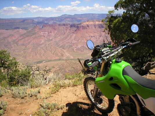
For my annual August Colorado dirt bike trip, I did the regular Silverton/Ouray/Telluride area thing for about 3 days and had the usual fun and enjoyment. However, longer term rain events seemed to be the norm for much of the high country this July and August. After riding a couple of days in the Rico, CO area, I headed over to Gateway, close to the Utah border. Wow!...what a nice surprise.
I didn't have maps of this area, so I picked up a Gazetteer, and it turned out to be fairly sufficient for some serious off roading in the area. I would occasionally verify some sketchy sections by pulling out my old Garmin IQ3600 GPS topo maps for verification. When I got home, some of the folks on ADV confirmed the vast amount of off road potential in this area that I didn't know existed. For 3 days I checked out the forested area to the east of Gateway on the Uncompahgre Plateau, the Dolores River Canyon to the northwest, and the John Brown Canyon area to the west. There are days and days of exploration to do in this area with big 2-track, small 2-track, and singletrack all over the place with side trips galore. I even came in from the east to just about eye shot of Moab over the La Sals. This is a very diverse topography going from river canyon red rock to aspen laden high forest. It's a relatively little known off road destination, but it's loaded with absolutely awesome on and off road riding. My KLX300S was just about perfect for all of it. I camped out of my van in the BLM land around Gateway, and the big, fancy resort located in town provided fuel and all manner of food and logistical necessities. As I understand from the locals, this resort is owned by the CEO of the Discovery Channel. It's a little rich and pricey for my taste and wallet, but it is impressive and provides all your needs for fuel and food. The post office is about the only other "commercial" facility. The weather was great and thankfully dry while all the high mountain areas to the east were getting a consistent rain event.
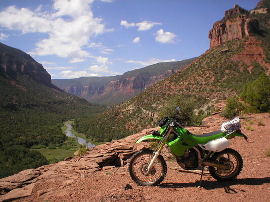
I then moved south on that highway 141 to Naturita, Slickrock, and Dove Creek. Again, Wow! I didn't realize there was so much interesting topography in this area. Around the Slickrock area, which really isn't a town as such, it looked much like Moab with tons of old mining roads and trails branching off everywhere. When I got to Dove Creek, I checked into the Dolores River access roads that branch off to the east of town in several places. I have been driving through Dove Creek since the 70's going to Moab. It's pretty but relatively plain, rolling farmland. My big surprise on this trip was the unbelieveably beautiful Dolores River Canyon that's only about 6 miles east of town.
I dropped into that canyon and went about 20 miles to the north. This canyon was big and utterly awesome. The river was flowing just on the right the whole time. The trail goes all the way to Slickrock if you cross the river at a known crossing point, but the river was flowing deeper and faster than normal at this point, so no crossing for me...especially traveling alone. This trail got rougher as you continued, but it was a fun type of rough. It looked like ATV's were normally the biggest thing to go through there, but some locals confirmed that a 4X4 with an experienced driven can make it. I turned around just before the crossing and returned the same way. This was a downright breathtaking trail. I cannot recommend it enough. With Dove Creek right on the way to Moab and just a few miles from Monticello, it's a great side trip when doing a Moab pilgrimage. In fact there are back roads and trails all over this area around the Slickrock area.
I was kind of glad that rainy weather pushed me over into some new areas, because I found all kinds of future potential for riding. A couple of the ADV folks that I know from CO are already planning a "meetup" to ride for 2 or 3 days in the area next year. I'd post some more pics, but the site is only allowing to post one even though the file size is small, e-mail size.
I didn't have maps of this area, so I picked up a Gazetteer, and it turned out to be fairly sufficient for some serious off roading in the area. I would occasionally verify some sketchy sections by pulling out my old Garmin IQ3600 GPS topo maps for verification. When I got home, some of the folks on ADV confirmed the vast amount of off road potential in this area that I didn't know existed. For 3 days I checked out the forested area to the east of Gateway on the Uncompahgre Plateau, the Dolores River Canyon to the northwest, and the John Brown Canyon area to the west. There are days and days of exploration to do in this area with big 2-track, small 2-track, and singletrack all over the place with side trips galore. I even came in from the east to just about eye shot of Moab over the La Sals. This is a very diverse topography going from river canyon red rock to aspen laden high forest. It's a relatively little known off road destination, but it's loaded with absolutely awesome on and off road riding. My KLX300S was just about perfect for all of it. I camped out of my van in the BLM land around Gateway, and the big, fancy resort located in town provided fuel and all manner of food and logistical necessities. As I understand from the locals, this resort is owned by the CEO of the Discovery Channel. It's a little rich and pricey for my taste and wallet, but it is impressive and provides all your needs for fuel and food. The post office is about the only other "commercial" facility. The weather was great and thankfully dry while all the high mountain areas to the east were getting a consistent rain event.
I then moved south on that highway 141 to Naturita, Slickrock, and Dove Creek. Again, Wow! I didn't realize there was so much interesting topography in this area. Around the Slickrock area, which really isn't a town as such, it looked much like Moab with tons of old mining roads and trails branching off everywhere. When I got to Dove Creek, I checked into the Dolores River access roads that branch off to the east of town in several places. I have been driving through Dove Creek since the 70's going to Moab. It's pretty but relatively plain, rolling farmland. My big surprise on this trip was the unbelieveably beautiful Dolores River Canyon that's only about 6 miles east of town.
I dropped into that canyon and went about 20 miles to the north. This canyon was big and utterly awesome. The river was flowing just on the right the whole time. The trail goes all the way to Slickrock if you cross the river at a known crossing point, but the river was flowing deeper and faster than normal at this point, so no crossing for me...especially traveling alone. This trail got rougher as you continued, but it was a fun type of rough. It looked like ATV's were normally the biggest thing to go through there, but some locals confirmed that a 4X4 with an experienced driven can make it. I turned around just before the crossing and returned the same way. This was a downright breathtaking trail. I cannot recommend it enough. With Dove Creek right on the way to Moab and just a few miles from Monticello, it's a great side trip when doing a Moab pilgrimage. In fact there are back roads and trails all over this area around the Slickrock area.
I was kind of glad that rainy weather pushed me over into some new areas, because I found all kinds of future potential for riding. A couple of the ADV folks that I know from CO are already planning a "meetup" to ride for 2 or 3 days in the area next year. I'd post some more pics, but the site is only allowing to post one even though the file size is small, e-mail size.