• Welcome to the Two Wheeled Texans community! Feel free to hang out and lurk as long as you like. However, we would like to encourage you to register so that you can join the community and use the numerous features on the site. After registering, don't forget to post up an introduction!

28 day solo ride TX, NM, AZ, UT and CO

DAY TWELVE OF TWENTY EIGHT which I think is really day 13 or 14

It was cold again last night, but my 20 degree sleeping bag did it's job. I woke up early because, even with ear plugs, the road noise was loud. Observation: most campgrounds put tent camping as close to the highway as possible. This particular KOA had us lined up parallel to I-15. At least it was a little distance away.
The last time I tried to go to the remote Section of Zion NP (Kolob Canyon), it was snowing and all three members of our group agreed we needed to bypass Zion and head straight to a motel with a hot tub. This time it was cold but not snowing. I-15 has an 80MPH speed limit. My DRZ has a slower cruise limit. I was very careful, with one eye on my six at all times. Zion Colob Canyon was the least crowded national park that I visited, outside of Texas.

Kolob Canyon
IMG_1751.JPG


IMG_1753.JPG


IMG_1760.JPG


IMG_1765.JPG


All pictures were taken from the road. It was cold and wet, but not raining, and I had a vented riding Jacket and a Frog Togg rain suit. My electric vest was left home because I was afraid it would overload the DRZ electrical system.

I retraced my route back to La Verkin and then east toward Virgin. I came across this roadside ostrich farm which fit right in with my deformed Yucca plant posted somewhere above.
IMG_1766.JPG


I decided to put the DRZ on roads it was designed for. These two pics are headed South from Zion on Smithsonian Butte Trail. The road heads south in the little town of Rockville. The scenery was so nice, I rode back the same way I came.
IMG_1771.JPG


IMG_1775.JPG


This one is in Zion itself. All of the parks in Utah were filled. Parking was a problem and I had been there recently, so I rode right through. An earlier post, “we test ride retirement,” has lots of pics of Zion if anyone is interested.
IMG_1777.JPG


I stopped at 3 campgrounds and all were full so it's going to be dispersed camping for free. It rained and the wind blew. Both of my bad shoulders gave me problems. I also spilled V-8 Juice in my tent and on my sleeping bag. By the way, if anyone has problems with muscle cramps, Spicy Hot V-8 Juice is my answer and it has never let me down. Motel tonight if possible so I can wash clothes and sleeping bag.
 
DAY THIRTEEN OF 28

No motel last night. I spent a very rough and cold night above Cedar Breaks. Ice crystals formed in my water bottles. I have a sleeping bag rated for 20 degrees, but even with socks, jeans and a t-shirt, I was cold. I got up late this morning. The wind and rain stopped last night, but the cold kept me in my sleeping bag until after 8:00. This trip is the 4th time I have tried to go to Cedar Breaks. A rock slide closed the road once and it was snowed in the other two times. There were snow flurries this morning and dense fog.
IMG_1778.JPG


This time it was fogged in and I was a little disappointed.
IMG_1779.JPG


I was disappointed until I saw the fog staying on top of the canyon.
IMG_1782.JPG


IMG_1785.JPG


In an earlier report I mentioned my disappointment at being snowed out of Cedar Breaks and I believe it was Throttlemeister that told me Cedar Breaks was a smaller version of Bryce Canyon and he was right. Since 1993, my policy is to try not to pass by a national park or national monument that I haven’t seen before. I can now drive right by Cedar Breaks. However, I will probably stop in the next time I come by.
IMG_1791.JPG


IMG_1801.JPG


An approximately 1600 year old bristlecone pine tree. During times of drought or other distress, parts of a bristlecone pine will die, leaving the intact root system to provide for a smaller tree. This ability allows them to survive in very harsh conditions
IMG_1806.JPG


IMG_1817.JPG


A much younger bristlecone has not seen the harsh conditions seen by the 1600 year old pine


IMG_1819.JPG


This is an alien creature that has adapted to the very harsh conditions of motorcycle riding. Notice the eyes that continuously scan for potential hazards while the brain continuously plays the “what if” game. These adaptations have allowed this creature to survive and even prosper while riding motorcycles for 56 years.
IMG_1808.JPG


In the early 1900s, the park service built log type lodges in several Utah national parks. They later tore them all down except for this forgotten shelter for a generator. Realizing their mistake, they have vowed to preserve this remnant.
IMG_1823.JPG


IMG_1824.JPG


DAY FOURTEEN OF TWENTY EIGHT

Motel last night. I got the V-8 juice and milk washed out of my sleeping bag. Oh yeah, I spilled my milk and cereal on my sleeping bag while trying to stay warm eating breakfast.

Parked in Red Canyon
IMG_1826.JPG


I and many others have posted many pics of Bryce NP. Here is a brief episode of me trying to take a picture of Bryce. It’s like showing a picture of a tree to someone who has never seen a forest and trying to explain to him what a forest is.
IMG_1828.JPG


IMG_1834.JPG


IMG_1835.JPG


IMG_1842.JPG
 
It's always great to see someone else enjoy so many of the places that I've been to.

Scott, "Hannagan" Meadow, it's not possessive.

Hwy 78 westbound from the cattle guard where you took your photo. This was probably 8 years ago.
 
Great pics! I love that area in Utah. It really reminds me of the trip I made out there a few years ago with my oldest daughter. She was 11 at the time. We exited the West side of Zion and went up over the mountains on Kolob Rd., which was freshly black topped and awesome! At the reservoir, it became dirt the rest of the way to Hwy 14, where we headed into Cedar City for the night at a hotel with a nice hot tub :trust: 
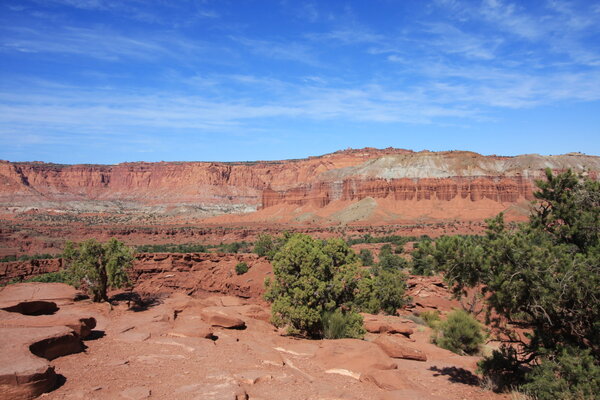
We hit Cedar Breaks the next morning. The nice thing about that park is that even though it is MUCH smaller than Bryce Canyon, it is not crowded like Bryce Canyon.

There are some cool dirt roads that run between Hwy 143 East of Cedar Breaks over to US 89 at Hatch. They are narrow and wind through huge piles of lava with Aspen groves growing all around them. The contrast between the dark colored lava and the brightly colored Aspens was really cool!
 
Thank you for posting all of this. I dream of a trip like the one you have documented.
 
Thank you for posting all of this. I dream of a trip like the one you have documented.
You're welcome. It's only half over. The great thing about this trip was no planning except for Big Bend and Guadalupe NPs. I also took maps of Idaho, Nevada and California and at one point I was headed to Death Valley NP. Southern Utah had a vacuum that sucked me out of Arizona and deposited me on some of the dirt roads of Utah.
 
Tourmeister, we like a lot of the same things. I think we would make good touring partners if it were not for my obsession for going cheaply. That character trait doesn't show itself when my wife is with me.
 
DAY FOURTEEN OF 28 CONTINUED

I stopped for gas at a station near a dirt road I wanted to ride. I asked the attendant about the condition of the road and he told me he didn't think my DRZ400 would have a problem, but he hadn't actually been on Skutumpah Road. He was right as this very old sign would stop my DRZ before it got started.
IMG_1844.JPG


I am constantly surprised by locals that have not seen something that I drove over a thousand miles to see. A waitress in Colorado Springs that had lived there all her life and never been up Pikes Peak, a store clerk in Durango who expressed an interest in going on the Alpine Loop for the first time and now this guy in southern Utah that has not been down Cottonwood Canyon road which starts 5 miles from where he works.

A change of plans. Skutumpah was supposed to be the first half of a one hundred mile ride that started and ended at Kodachrome State Park. If Skutumpah was closed then a ride down Cottonwood Canyon Road and back was the thing to do. Within the first mile. It makes me kind of glad Skutumpah road was closed.
IMG_1847.JPG


There is a rare double arch in white sandstone. Arches are rare, and most in Utah are red sandstone. The name of this rare arch is Grosvenor, a strange name and there was no explanation at the site. My vivid imagination came to this conclusion: A Group of East Europeans discovered the arch. One of them was named Venor, probably a distant cousin of Vladamir. Anyway, when Venor saw the arch as the first non Native American to do so, he commented that the smaller hole looked like a giant nostril and the larger arch was a petrified nasal discharge. His friend the beautiful Miss Anastasia said, “That’s gross Venor,” and that became the name of the arch until time to actually put the name on the sign. There wasn’t enough room for Gross Venor Arch so the space was taken out. Still not enough room so they deleted one of the Ss. Grosvenor Arch, a beautiful double arch off Cottonwood Canyon road.
IMG_1859.JPG


IMG_1849.JPG


Down the road from Grosvenor.
IMG_1864.JPG


A recommended hike, about 1 ½ miles, with a similar hike back to the bike, that starts at the south entrance. If there are 2 of you, a bike can be used as a shuttle.
IMG_1865.JPG


A simple start.
IMG_1866.JPG


It very quickly turns to this and better for a mile and a half.
IMG_1868.JPG


IMG_1890.JPG


There is a little blockage so carry a short rope to lower backpacks or cameras down about 5’ before jumping.
IMG_1908.JPG


The walk back ain’t too shabby either.
IMG_1915.JPG


I spent the night along Cottonwood Canyon, probably illegally. There was a sign that said all campers must register so I stopped. The registration card asked for a camp location and since I had never been down Cottonwood Canyon before, I had no Idea where I would stay. I left without registering.
 
Utah is beautiful but baffling to me. I heard someone say it's like the Almighty had all these random parts left over from the creation so He just threw em into a place we call Utah. It's crazy the diversity from one end to the other. Great pix of some places I haven't been. Thanks!
 
Utah is beautiful but baffling to me. I heard someone say it's like the Almighty had all these random parts left over from the creation so He just threw em into a place we call Utah. It's crazy the diversity from one end to the other. Great pix of some places I haven't been. Thanks!
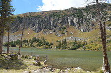
Crazy rocks, high mountains, deep canyons, beautiful waterfalls, forest, desert and beautiful lakes and rivers all in one state. God sure did have some stunning pieces left over when he did the creation. I love Utah.
 
DAY FIFTEEN OF TWENTY EIGHT

It froze again last night. The irrigation sprinklers around Tropic were coating the alfalfa with ice. I had breakfast in bed again, did a short ride south toward 89A to make sure I didn't miss anything on Cottonwood Canyon road and then did a U turn back to highway 12. Advance planning ceased last night since I have changed my mind on just about everything I have preplanned. The sign to "****'s Backbone" caused me to do another U turn and that was my new destination for the day.

A rest stop complete with pit toilet that is along highway 12. I have stopped here twice before and both times, the Desert Doctor rode up and gave me his card. He did not show up this time, and I needed chain lube. That’s not really maintenance, but it is a sale. I went by his shop and was told he was out riding to see if any riders needed help. I still need chain lube, and now a new front tire. 3,800 miles of dirt and street is the useful life span of a front Pirelli Diablo.

IMG_1920.JPG


Close to the top of ****’s Backbone.
IMG_1930.JPG


Boulder was the last town in the US to get their mail by mule. The fastest way from Escalante (pronounced ???? even the locals can't agree) to Boulder was by way of ****'s Backbone and that's the way the young mail carriers went since they were getting paid by the trip, not by the hour. At least one mule fell and died. During the New Deal, the WPA built a bridge using 2 large felled trees as the support. Some very brave young man drove a bull dozer across the two trees to test for strength. There is also a version where he went across just because they needed the bull dozer on the other side. You pick. Trivia: The entire town of Boulder was on a single party line telephone circuit until 1955. Imagine sharing phone time with about 150 others.

Looking down into the canyon from the far side of the bridge, foot added for scale.
IMG_1940.JPG


The current bridge across Hells Backbone. It's the third generation.
IMG_1947.JPG


Looking down on the start of the Canyon that’s on the paved portion of Burr.
IMG_1989.JPG


My camp at the head of Boulder Canyon.
IMG_1951.JPG


I had stopped at the junction of Burr Trail and Hwy 12. Apparently there is a 72 year old man, the same age as I, missing for 5 days. It took me a quite a while to get here, riding slowly to scan the sides of the road. I can’t imagine him being able to survive. The temperatures have been dipping into the mid 30s for the last 5 days. I called this morning and they have still not found him. He's been missing for more than 5 weeks now.
 
I am constantly surprised by locals that have not seen something that I drove over a thousand miles to see. A waitress in Colorado Springs that had lived there all her life and never been up Pikes Peak, a store clerk in Durango who expressed an interest in going on the Alpine Loop for the first time and now this guy in southern Utah that has not been down Cottonwood Canyon road which starts 5 miles from where he works.

I have run into this as well and it totally boggles my mind. How could someone NOT want to know what was on the other side of the hill or around the corner...? :brainsnap

My son and I were stopped in Mt Judea, Arkansas, at the Eagle Cafe there on Hwy 123. We were contemplating running up over the mountains to the East of town on my GS. I asked the waitress if she knew whether the roads went through and whether they were dirt or paved. She had no clue. She had NEVER been out of the little valley where Mt Judea sits and had absolutely no desire to see what lay beyond its edges! We were the only people there at the time so she got the guy cooking to come up front and we asked him. Same thing again. Both were in their early 30s and had never ventured more than 2-3 miles from where they lived. They were literally born in that valley and had lived their whole lives there, neither wishing to know what the outside world might be like beyond what they saw on TV or the internet. I cannot fathom their mindset, but they said they had everything they needed right there :shrug:
 
DAY SIXTEEN OF TWENTY EIGHT

I camped last night, but the addition of a hoodie to my wardrobe made sleeping easy and warm.

Into the canyon.
IMG_1959.JPG


Looking the other way. After 15 or 20 miles, this gets really boring. :)
IMG_1960.JPG


Out of the canyon and heading into the distance.
IMG_1965.JPG


The start of Capitol Reef NP and the start of 73 miles of dirt, according to the sign. I didn’t measure, but I really doubt it’s 73 miles of dirt.
IMG_1967.JPG


You can’t see them all, but there are 5 tight switchbacks (tighter than Moki Dugway) going down the Waterpocket Fold. The only road through in the 100 miles of the Waterpocket Fold.
IMG_1973.JPG


Hugging a hill.


IMG_1981.JPG


After Burr intercepts the Notum Bullfrog road, the road got very sandy. It follows the Waterpocket Fold which was not as impressive as the Vermillion Cliffs were, so I turned around. The ferry was not operating that day, so I couldn’t have gotten across the lake anyway.

I needed some chain lube. I had been removing my oil fill and dipping a fairly clean stick into the engine oil and then dripping the oil off the stick onto the chain. I had been doing that for 3 days. This Desert doctor saved the day. If you go to his shop, your immediate response will be, “What the ****.” In a series of sheds, he has two bike lifts, a mill, lathe, various other machine tools, a full welding shop with TIG and MIG, tool boxes galore, various parts and, according to him, 100+ tires. I didn’t count, but he had a LOT of tires. By talking to him, I can tell you he is very knowledgeable about motorcycles and knows how to use the machine shop and welding shop. He also has a very impressive stack of testimonials from satisfied customers. This sign is a recent gift from one of those satisfied customers.
IMG_1996.JPG


He also produces “art.” Art is supposed to be in the eye of the beholder and he beholds differently than I.
IMG_1997.JPG


Lots of clock art.
IMG_1998.JPG


He does have a manual Coats tire changer, but says he can do them faster on this machine. I wasn't going to make a bet. Garvin Allen once bet me that he could change a rear tire manually on the floor of Lane Budd's shop faster than I could using a Coats manual machine. Let's just say I bought the pizza that night.
IMG_1999.JPG


This is evidence that someone came up with a more stupid idea than my idea to build an aluminum trailer with a Harbor Freight motor to push my bicycle. Does anybody know where to get an 11 foot long throttle cable for an XR100? I know, if anyone else needs one. It will have to be paid in full before it will be assembled and shipped even if you have had an account since 1988. Desert Doctor did not build this chopper, but has it on display outside his shop.
IMG_2001.JPG


The Desert Doctor, a really, really nice guy. And, he owns the only MC shop within 200 miles. GPS- N 37Deg 46.109’ W 111Deg 36.03’
 
Last edited:
DAY SEVENTEEN OF TWENTY EIGHT

I camped last night in an RV park in the town of Escalante. If you are following my escapades on a map, you know that I went back and forth on highway 12 several times. That is a really good thing unless you are afraid of heights. The road drops off on both sides. The reason for the RV park is, and I quote my notes, "I'm so sandy that I have sand wedged between my teeth." A note to future Burr Trail/Notum/Bullfrog riders: A Pirelli Diablo front tire is not good in deep sand.
I woke up to the sound of many flocks of geese. I popped out of bed after sleeping warmly due to my new hoody.

I decided to go down The Hole in the Rock Road as far as Spooky and Peek-A-Boo slot canyons. It was about 32 miles and 22 of that was deep sand. Worn street tires do not do well in deep sand, but due to the DRZ having a bullet proof clutch, I made it.

The first stop was about 10 miles in and it was called the Devils Garden. This name popped up again for a spot in Arches NP, so I’m thinking theses Utah Mormons might have a problem with so many devils planting gardens in their neighborhood.
IMG_2004.JPG


IMG_2009.JPG


And this was the weirdest of them all
IMG_2012.JPG


After what seemed like 4 to 5 hours, I made it to the dry fork trailhead, home of both slot canyons. Most people hike up one and back down the other. Because Peek-A-Boo is a little intimidating, some hike up Spooky and then back down. There is also a third canyon that some hike down, thinking it is Peek-A Boo. Peek has a 20’ drop filled with 6’ to 10' diameter chock rocks. I was there at least 20 minutes trying to find a way down. I didn't want to try any of the possible routes until someone else was there. Dropping down one of the chock rocks into a dead end would have meant I was stuck there until help came. I wanted help to already be there. The couple behind me opted out and went back down Spooky the way they came, even after I showed them a successful way down.


IMG_2016.JPG


The entrance to Spooky.
IMG_2021.JPG


Looking up through an arch in a slot canyon at what appears to be another arch above. It is not. That is just the undulating walls cutting off the view of the sky.
IMG_2026.JPG


This is Arno, from the Netherlands, getting stuck. He did eventually get through this tight spot as well as a couple more that were even tighter. If he had attempted Peek, he would have had to do a little horizontal hiking. His wife Lucy is behind him.
IMG_2028.JPG


Me at one of the shallower areas. The bottom was still narrow.
IMG_2032.JPG


Water makes all sorts of weird, but beautiful, shapes.
IMG_2033.JPG


Arno about to get stuck again.
IMG_2036.JPG


Arno stuck again
IMG_2043.JPG


Water bottle added for perspective. Looking back the way I had just came as I entered Peek.
IMG_2053.JPG


Looking deeper into Peek.
IMG_2054.JPG


Another arch in a slot.
IMG_2056.JPG


Same arch, other side. Sometimes the floor was wide.
IMG_2059.JPG


And sometimes the floor was not very wide.
IMG_2071.JPG


Lots of this in Peek. I had to put my feet on one wall and my back to the other and hike horizontally because I have eaten too many donuts. Apparently not as many as Arno.
IMG_2078.JPG


One more.
IMG_2083.JPG


On the ride out, a hitch hiker asked for a ride. I explained about the deep sand and he said he wanted to try anyway. We strapped his backpack to my rear box and started out. We didn't get 50 yards before he tapped out.
 

Attachments

  • IMG_2077.JPG
    IMG_2077.JPG
    175.5 KB · Views: 193
Last edited:
I stayed in the same RV campground again. Sand in my shorts again and I didn't want the weight of the saddlebags and tent on the bike for 20+ miles of deep sand.
 
On the ride out, a hitch hiker asked for a ride. I explained about the deep sand and he said he wanted to try anyway. We strapped his backpack to my rear box and started out. We didn't get 50 yards before he tapped out.

:rofl:
 
DAY EIGHTEEN OF TWENTY EIGHT

I was very tired when I got back to camp and slept soundly. Today would mainly be a travel day to get closer to Canyonlands and Arches NPs. Closer, because I needed to stop in Monticello for tires at the local Honda shop.

Chimney rock. There are lots of rocks named Chimney in lots of different states. Most look more like a chimney than this one. There was a trailhead in this parking area, and the scenery made it look enticing, but time was not available.
IMG_2094.JPG


The white layer here is the Kaibab layer. It creates the lower layer of this canyon and is the upper layer of the Grand Canyon. It’s about 270 million years old, give or take a year. Geologists estimate this area erodes down 7-10” every thousand years. All this info on a sign.
IMG_2098.JPG


Sunset Point trail led to some beautiful sights. 1/3 mile is a manageable hike even if I am in a hurry.
IMG_2106.JPG


It’s amazing what a difference in what one can see by just hiking 0.3 miles. Sunset Point view
IMG_2114.JPG


Just along the highway. I believe this is just west of Hanksville. Others have posted the same view and can correct me if I’m wrong.
IMG_2116.JPG


Riding through a canyon on highway 95. Looking north
IMG_2120.JPG


Looking south from the same spot
IMG_2121.JPG


I’m not skilled enough with a camera and I don’t know how to do post processing, but this is a beautiful iconic shot of a bridge over the Colorado River at the upper reaches of Lake Powell. That is, when the light is favorable for us camera challenged riders. I have posted better in earlier reports.
IMG_2124.JPG

I got to Monticello just at dusk. The web site said they opened 9:00 to 6:00 on Saturday. I got a rare motel room, bought a can of WD-40 and headed to the local car wash. I sprayed the engine, swing arm, chain and rear rim with WD-40 and rinsed it off with the sprayer. I figured they would be more likely to fit me in if the bike were not so grimy. If they didn’t have my size tires, I was going to order and come back on Tuesday. I pull up at 9:00 the next morning to read: “We will be closed on October, 5th.”
 

Attachments

  • IMG_2094.JPG
    IMG_2094.JPG
    400.1 KB · Views: 191
  • IMG_2098.JPG
    IMG_2098.JPG
    357.2 KB · Views: 197
  • IMG_2098.JPG
    IMG_2098.JPG
    357.2 KB · Views: 204
  • IMG_2107.JPG
    IMG_2107.JPG
    384.7 KB · Views: 195
I have a ride planned this weekend. I'll finish up next week with Canyonlands, Arches, a short ride in Colorado and a return to ruins in New Mexico. Also, Big Bend and Mexico will finally happen.
 
Awesome report and photos. :clap:

I really need to do something like this.
 
Amazing, I feel like a wimp with my comfortable aftermarket seat on an FJR only doing 5 day trips.

Being strictly a street rider, I felt a little anxious seeing pictures of all those dirt roads and being far from pavement. I actually felt relief looking at your pictures of I95!

Thanks for sharing.
 
Back
Top