• Welcome to the Two Wheeled Texans community! Feel free to hang out and lurk as long as you like. However, we would like to encourage you to register so that you can join the community and use the numerous features on the site. After registering, don't forget to post up an introduction!

A Summer Long Ride

US-395 is another one of my favorite roads. I headed south from Coleville where I am staying to June Lake. The photo is from the overlook above Mono Lake. The mountains on the right is the eastern most section of Yosemite National Park.

143DC8EE-5CF2-423C-9515-8DF4A99F7B9A.jpeg

The other side of the lake is where High Plains Drifter was filmed.
 
Last edited:
Since I could not get into Yosemite, I headed east on CA-120 towards Benton Hot Springs which is on the Nevada border. This section of CA-120 is lots of fun.

78E7E121-BCF2-4DA4-BCBF-8C74CA621B30.jpeg
 
Last edited:
I have seen this out of the corner of my eye on many trips through here over the years but I stopped this time.

56ACE4AA-0F4C-4359-8A3D-060E99188879.jpeg
 
Mud slides have closed Ebbets pass. Sigh. Decided to go see something I haven’t before. Donner Lake - site of the infamous Donner party buffet. Tahoe is on the way….
5FF4F2CA-B3B2-4FD9-8C4B-1E34B78E7293.jpeg
 
Wow, just found this. Excellent write up, fantabulous pics and thanks so much for sharing your routes. Keep it rubber side down, and keep the report coming. I'm very envious, but don't mind living through you righr now since I'm still trapped in "the furnace"!
 
Wow, just found this. Excellent write up, fantabulous pics and thanks so much for sharing your routes. Keep it rubber side down, and keep the report coming. I'm very envious, but don't mind living through you righr now since I'm still trapped in "the furnace"!
Thanks. I appreciate that. I have about 50 miles of splitting in front of me so I’ll take all the help I can get. It gets pretty nerve wracking after about 10-20 miles.

It seems like everyone else decided to see the Donner memorial too so I turned around, rode back along the lake and am now headed into the California Central Valley heat.
 
It was only 95 so I should count my blessings. Interesting thing happened on the way. I tucked in behind a car to take it easy for a few minutes. I look in my mirror and a HD with ape hangars is tail grabbing me. I move over to the right and let him through. I watch him from a close distance for the next ten miles.

All the sudden it looks like he had a blowout on his front tire and is fighting to keep control. I passed by him then immediately moved into the emergency lane and stopped. I was going to see if I could help. I have lost sight of
AAD689F7-75BA-4BE2-A9A6-8C3A6F394081.jpeg
him at this point. All of the sudden cars are pulling in behind me and people are getting out and running backwards.

Right after I lost sight of him he lost control and flew off what had to be a 30 foot embankment. Considering he did not have a helmet on, I think he turned out to be lucky. The bike not so much.

I asked him if he was all right and he said yes. He told me his handlebars folded on him. Oops
 
Got to love "ape hangers"!!! Glad he made it out considering he wasn't wearing a helmet. I'm not sure why anyone would ride without a helmet. Maybe nothing in there to protect!
Well I hate to judge a book by its cover but there is truth to what you say. :lol2:
 
It ends too soon. Back to the furnace today. My 24 year old daughter will be joining me for Part 4.
Here is a photo of Monitor pass California which is just a fantastic road.

ADC45536-25D1-4C3D-8340-A4A3901DFF55.jpeg


E0584911-DE71-466A-B077-F7CF5FC7097A.jpeg
 
Now that I am back home, it's time to finish Part II...

Day 8 - Bellevue, Idaho to Joseph, Oregon

I woke up with enthusiasm today. Ever since I last exited this area three years ago, I have wanted to see the Sawtooth mountains again. On top of that, the latter half of today's route forward is all new roads until California. I also get to add Oregon to my map.

wheremap.jpg


Today's route map

map8.jpg


It was a nice but relatively slow crawl through Sun Valley. The mostly barren mountain sides slowly changed over to dense tree cover. Elevation and twisty roads increased to a level that makes it hard not to smile. Anxious to see the Sawtooth mountains again, it was a real pleasure to ride around a corner and see them. This is the Galena summit overlook.

day8-2.jpg

The Sawtooth mountains - Idaho

day8-3.jpg

As usual, photographs have difficulty properly representing height and depth. Even so, this is an amazing scene. One can easily see how they got their name.

day8-1.jpg

I really had to pry myself away from this location. The mountains, cool air and lush greenness were refreshing.

day8-4.jpg

Back on the road to Stanley...

day8-5.jpg

Enjoying the view as I give the HD riders in front of me some space.

day8-6.jpg

This road is a lot of fun on a canyon carving speed machine.

day8-7.jpg

As a native Texan, the thought of a river with something as tasty as salmon in it blows my mind.

day8-8.jpg

If I did not know better, I would think I was on Chief Joseph Highway.

day8-10.jpg

The snow covered Sawtooth mountain peaks.

day8-11.jpg

Idaho has the best historical road signs I have seen yet.

day8-12.jpg

There seem to be many orbs in my gopro shots. I sometimes wonder what that is all about.

All in all, this looks like a fantastic area to spend more time in. Especially, if on ADV or dirt bikes. Now, on to Stanley and Grime's pass...
 

Attachments

  • day8-9.jpg
    day8-9.jpg
    567.9 KB · Views: 90
  • wheremap.jpg
    wheremap.jpg
    161.5 KB · Views: 141
Last edited:
Day 8 continued - Grimes Pass

I took the express route through here last time. This time, I decided to slow things down a little and concentrate more on scenery than making corners. This cool little pullout is close to the start and makes for a great place to take a break, enjoy the river and get the gopro ready.

day8-14.jpg

The power of mother nature never ceases to amaze me.

day8-13.jpg


Unfortunately, I did not have my gopro facing high enough. The in-flight photos turned out ok but not as good as they could have been. Still, what a remarkable experience to ride through such a rugged canyon high above the Payette river.

day8-16.jpg

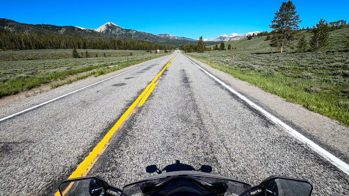
Riding the pass from the east starts with a dense cover of trees.
day8-17.jpg

The trees slowly become sparse and rocks plentiful.
day8-18.jpg

The Payette River comes into view.
day8-21.jpg

The river descends further down the canyon as I start my climb over Grimes pass.

day8-23.jpg

Until you cannot see it anymore...
day8-26.jpg

day8-33.jpg

I am not sure if those are saw teeth or bear teeth. Maybe some one here knows.

day8-34.jpg

On the decent, the river comes back into view.

day8-38.jpg

Exiting the pass near Banks the scenery becomes picturesque again.

Both times that I have turned north onto Idaho-55, I have instantly regretted using all my battery power for the gopro. While this road is heavily traveled, the Payette river is intense and provides miles upon miles of raging white water. However, there is so much vehicular traffic that passing is almost impossible. This makes for a real slow grind all the way to McCall.

At McCall, I took a much needed lunch break at a convenience store. The temperature was approaching 90 which reminded me I better put sun screen on or else. After hanging out for a half hour or so, I continued towards my next destination - Joseph, Oregon. Before that, I passed through a mostly hot and featureless area I suspect is home to many Nez Perce, which is terribly sad.

I eventually joined up with the Snake River in Hells Canyon. Just like everywhere else that has the word "hells" in it, it was hot hot. My ambient air sensor showed 101 which made me wonder why I came this way. However, cooler air blowing off the Snake River helped keep things mostly reasonable. Still, I was hot and a little tired at this point and did not feel like stopping. The road hugged the cliffs on the Idaho side making for some serious leaning and a little puckering too. Eventually, I crossed over the river into Oregon and continued following it for some distance. I wish I had stopped and taken some photos but it was just too hot. Taking a bath in my sweat just wasn't in the cards.

A short distance later, I started my way up the Wallowa Mountain loop wondering if it would allow me passage all the way into Joseph. It would be a real drag if I had to circle back around through LaGrande. Fortunately, the road was nicely paved and after some elevation gain, the heat started to subside. I thought the view would be better along the loop but I was hemmed in by trees most of the time so it was difficult gauge most elevation gain.

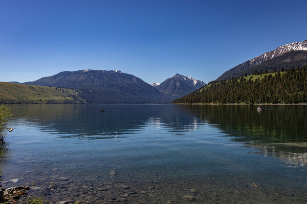
The real magic of the Wallowa valley came into view as I stepped down towards the town of Joseph. This is the only place in the United States I have ever seen that looks like an Alpine wonderland. I was blown away by the view of the lake and mountains that surrounded it. Through my studies of Chief Joseph and the rest of the Nez Perce, I had always imagined this area would be beautiful, but I really had no idea until now.

day9-2.jpg
 

Attachments

  • day9-1.jpg
    day9-1.jpg
    353.7 KB · Views: 90
Last edited:
Thanks for sharing!

You're a brave man riding all over on an FJR without crash bars!

You bet. This is my third FJR. Brave is probably not the right word for rolling the dice. Especially given I have already made the $2000 mistake twice. I have tried (not recently) to get my hands on some canyon cages or something similar without success.
 
I made my way to my hotel, checked in and walked down the hill to the state park. On the way, I crossed the Wallowa river which is pure snow melt. If you stick your foot in, the pain is instantaneous.

day9-4.jpg


day9-5.jpg

A little closer to golden hour, the photos are taking themselves. This is looking back towards the Wallowa Whitman National Forest.

day9-7.jpg

The Wallowa river turns into Wallowa Lake. At this point, I am wondering how this place escaped my attention for so long. Wow!

day9-6.jpg

As the hotel owner told me, someone has to want to come here to find it. Examining the location on a map makes his point obvious. I try to imagine living here in the 19th century as Chief Joseph did.

End of Day 8
 
Thank you for the kind words. Twelve years ago, I had no idea how to ride long distances. I have benefited so much from other people's reports it really is the least I can do.
 
Day 9 - Joseph, Oregon

Anticipating this stop, I added a couple extra days of buffer to my route to properly enjoy it. The first thing I did was get on the bike and ride back to the northern end of the lake. I will say it again, this reminds me of the Alps. Specifically, the lake district east of Salzburg, Austria.

day9-14.jpg


I headed into the town of Joseph looking for breakfast but did not find anything open on a Monday. I rode back towards the mountains and explored an area at the end of the main road. The mountains above here dump multiple streams into the Wallowa river.

day9-15.jpg


day9-16.jpg

These small streams are scattered all over the forest and make keeping my shoes dry practically impossible.

day9-17.jpg

The main body of the river.

 
For years I have heard stories about how hot it gets in eastern Oregon and Washington. I did not realize that 100 degrees is quite common. Maybe even more so than Texas during normal weather patterns. Even under the cover of trees, it was warming up so I decided to escape to elevation via the Wollowa Tramway.

day9-20.jpg

Of course too late but this is when I started to scrutinize the employees a little. Do they look like they are on top of all of this? No, they look like they stopped off at the dispensary on the way to work today.

day9-24.jpg

Looking towards the south, the snow starts to really make a showing.

day9-26.jpg

Just a fantastic view of the lake and valley. On the horizon, Washington state is located just beyond the ridge lines.

day9-23.jpg

There are multiple ridges that must be climbed over before reaching the summit.
 
Back
Top