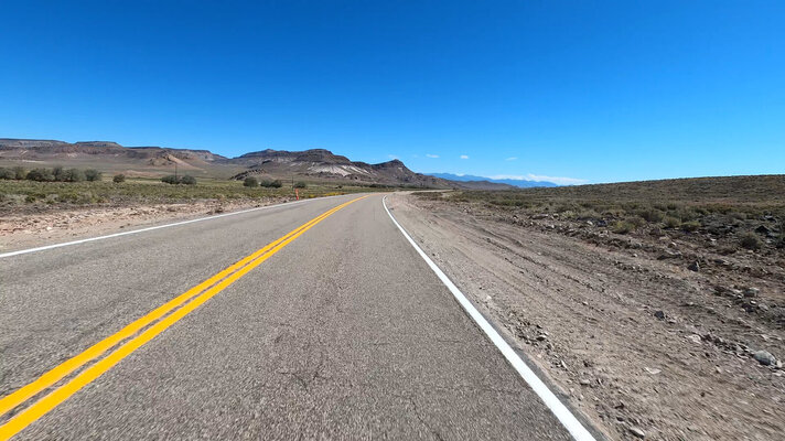
Warm Springs Nevada


-
 Welcome to the Two Wheeled Texans community!
  Feel free to hang out and lurk as long as you like. However, we would like to encourage you to register so that you can join the community and use the numerous features on the site. After registering, don't forget to post up an introduction!
You are using an out of date browser. It may not display this or other websites correctly.
You should upgrade or use an alternative browser.
You should upgrade or use an alternative browser.
A Summer Long Ride
- Thread starter LicketySplit
- Start date

Gotta love red rock country

- Joined
- May 22, 2013
- Messages
- 3,916
- Reaction score
- 2,892
- Location
- Thorndale, tx
- First Name
- Ed
- Last Name
- Baker
I think I need to do a ride out to Lovelock, NV and put flowers on my family graves. Then, maybe visit my 93 yo mom in Monterey, CA. That seems like an nice family oriented thing for me to do next month doesn't it ? ") BTW, I grew up on Mt. Hamilton Road, then moved back on it a mile from where I grew up in my 40's.
BTW, I grew up on Mt. Hamilton Road, then moved back on it a mile from where I grew up in my 40's.
View from the Kaibab

- Joined
- May 22, 2013
- Messages
- 3,916
- Reaction score
- 2,892
- Location
- Thorndale, tx
- First Name
- Ed
- Last Name
- Baker
I just need to be riding in utah right now.
I spent last night camping with Jredford and Eddie at the Vermillion cliffs at Marble Canyon.


Those guys spent the afternoon riding the mesa above the cliffs. I just hung out and enjoyed the scenery with an occasional screech from a Condor.

But before I found their campsite, I spent a couple of hours hanging out at the Grand Canyon North Rim.


Those guys spent the afternoon riding the mesa above the cliffs. I just hung out and enjoyed the scenery with an occasional screech from a Condor.
But before I found their campsite, I spent a couple of hours hanging out at the Grand Canyon North Rim.
Well, I guess I should not have mentioned the weather being good along the entire route. Cool rain set in New Mexico and eastern Arizona. I spent all day in it yesterday and then again this morning.
I have a few more photos to post and then I’ll be wrapping this report up.

I have a few more photos to post and then I’ll be wrapping this report up.
Last edited:
Day 22 - Santa Clara, California to Lee Vining, California
Thinking about it all, I found it strange to be once again on my way home from the bay area. This is my late wife's home, not mine. After her memorial service in 2020, I decided I had no more reasons to come to California. However, I slowly changed my mind as I accepted there were some important things left unsaid. From its inception, the primary goal of this trip was always to visit my wife's grave and speak to her. I was able to do that and will forever be grateful for the opportunity to start moving forward, if only ever so slightly. But, enough of that and on with the video and photos...
I can't believe I am saying Day 22 but on this day I headed east over Mount Hamilton and down the other side into the central valley. It was a nice cool day which made even the central valley a nice experience. Something about tomatoes, almonds, strawberries, blueberries, oranges and lemons growing on the sides of the road has way of cheering me up. After about two hours total, I was back outside the town of Sonora but turning onto CA-120 this time for a ride through Yosemite. I was up in the air about visiting the valley but it was only two in the afternoon which meant I had plenty of time to.
Make sure video quality is set for 2160 4K
Music - "Lust for Life" by Iggy Pop
Music - "What goes on" by The Velvet Underground

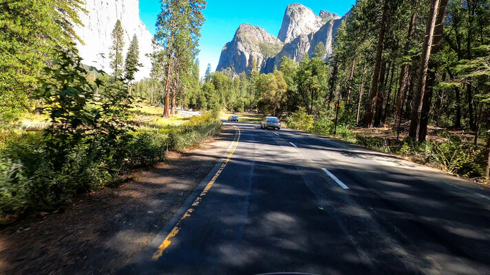
This is the first of three tunnels on the way down into the valley.

The valley starts slowly opening up.

The granite in the Sierra Nevada looks a lot like some places in the Alps.

Looking towards El Portal


Down into the valley with the very low Merced River on the right.

Cathedral Peaks

El Capitan

I have been in Yosemite Valley a few times before. I have loads of photos so did not feel compelled to do much more than ride around the valley and then back out onto CA-120 Tioga pass next...
Thinking about it all, I found it strange to be once again on my way home from the bay area. This is my late wife's home, not mine. After her memorial service in 2020, I decided I had no more reasons to come to California. However, I slowly changed my mind as I accepted there were some important things left unsaid. From its inception, the primary goal of this trip was always to visit my wife's grave and speak to her. I was able to do that and will forever be grateful for the opportunity to start moving forward, if only ever so slightly. But, enough of that and on with the video and photos...
I can't believe I am saying Day 22 but on this day I headed east over Mount Hamilton and down the other side into the central valley. It was a nice cool day which made even the central valley a nice experience. Something about tomatoes, almonds, strawberries, blueberries, oranges and lemons growing on the sides of the road has way of cheering me up. After about two hours total, I was back outside the town of Sonora but turning onto CA-120 this time for a ride through Yosemite. I was up in the air about visiting the valley but it was only two in the afternoon which meant I had plenty of time to.
Make sure video quality is set for 2160 4K
This is the first of three tunnels on the way down into the valley.
The valley starts slowly opening up.
The granite in the Sierra Nevada looks a lot like some places in the Alps.
Looking towards El Portal
Down into the valley with the very low Merced River on the right.
Cathedral Peaks
El Capitan
I have been in Yosemite Valley a few times before. I have loads of photos so did not feel compelled to do much more than ride around the valley and then back out onto CA-120 Tioga pass next...
Attachments
-
 GX010238.00_04_29_29.Still019.jpg500.5 KB · Views: 79
 -
 GX010238.00_05_16_43.Still020.jpg570.2 KB · Views: 77
 -
 GX010238.00_06_18_42.Still021.jpg518.1 KB · Views: 80
 -
 GX010238.00_06_41_20.Still012.jpg681.9 KB · Views: 75
 -
 GX010238.00_00_18_15.Still004.jpg123.4 KB · Views: 78
 -
 GX010238.00_02_44_03.Still010.jpg439.4 KB · Views: 83
Day 22 continued - CA120 - Tioga Pass
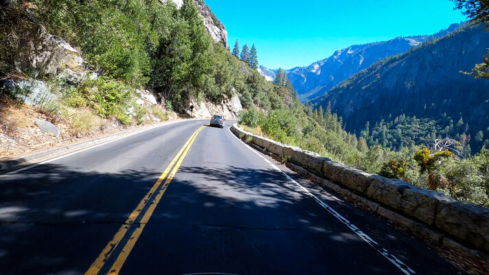
When in the valley, one must hike a little and sometimes a lot to get close up photos of the geologic features. Knowing I already have hundreds of these type photos from previous trips, I stayed on the bike and circled back to CA120 which is my favorite area of the park. This year it was especially nice with fewer people than I have ever seen before. Oddly, my favorite area on CA120 is just outside the east gate. I spent some time here in August and then again on this day enjoying the lakes, Tioga peak and the pass that leads into the Nevada high desert.
Set video quality to 2160p
Here are some photos inside and outside of the park boundaries...

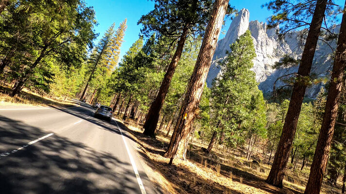
The Sierra Nevada has the most gorgeous granite of any range in the US.

On the right, looking back into Yosemite Valley.

An iconic view of Tenaya Lake emerging from the valley below.

Tenaya Lake - One of the most amazing sights in the park.

Tenaya Lake from a photo I took back in 2015. One of my favorites of all time.

Tenaya Lake continued...

Tuolumne Meadows is baked to a crisp this year.

Just outside of the east gate is Ellery Lake. An absolutely gorgeous body of water surrounded by Mount Dana and Tioga Peak.

Ellery Lake with Mount Dana in background. If you want to camp here you will have to figure out how to deal with the bears.

Another shot of Ellery Lake with Mount Dana in the background. The video of this area looks amazing!


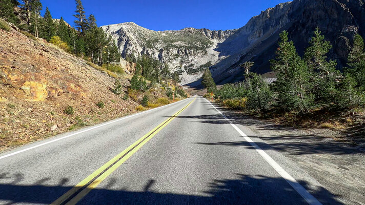
Around the corner towards Tioga Valley with Lee Vining Peak in the background.
 A look down Tioga Pass Valley.

And finally, a look at the turning leaves...
I usually ride all the way to Tonopah, Nevada on my first day east. This time, I decided to slow things down a little and enjoy Yosemite without having to rush. Lee Vining is just a few miles from the beginning of the pass which made for a nice and quick end to the day. The little towns along US 395 all seem to have at least one burger stand with above average food and in this case, ice cream too. Combined with a fantastic view of Mono Lake, dinner tasted especially good on my first day.
When in the valley, one must hike a little and sometimes a lot to get close up photos of the geologic features. Knowing I already have hundreds of these type photos from previous trips, I stayed on the bike and circled back to CA120 which is my favorite area of the park. This year it was especially nice with fewer people than I have ever seen before. Oddly, my favorite area on CA120 is just outside the east gate. I spent some time here in August and then again on this day enjoying the lakes, Tioga peak and the pass that leads into the Nevada high desert.
Set video quality to 2160p
Here are some photos inside and outside of the park boundaries...
The Sierra Nevada has the most gorgeous granite of any range in the US.
On the right, looking back into Yosemite Valley.
An iconic view of Tenaya Lake emerging from the valley below.
Tenaya Lake - One of the most amazing sights in the park.
Tenaya Lake from a photo I took back in 2015. One of my favorites of all time.
Tenaya Lake continued...
Tuolumne Meadows is baked to a crisp this year.
Just outside of the east gate is Ellery Lake. An absolutely gorgeous body of water surrounded by Mount Dana and Tioga Peak.
Ellery Lake with Mount Dana in background. If you want to camp here you will have to figure out how to deal with the bears.
Another shot of Ellery Lake with Mount Dana in the background. The video of this area looks amazing!
Around the corner towards Tioga Valley with Lee Vining Peak in the background.
And finally, a look at the turning leaves...
I usually ride all the way to Tonopah, Nevada on my first day east. This time, I decided to slow things down a little and enjoy Yosemite without having to rush. Lee Vining is just a few miles from the beginning of the pass which made for a nice and quick end to the day. The little towns along US 395 all seem to have at least one burger stand with above average food and in this case, ice cream too. Combined with a fantastic view of Mono Lake, dinner tasted especially good on my first day.
Attachments
Last edited:
- Joined
- Nov 25, 2012
- Messages
- 18,504
- Reaction score
- 678
- Location
- Lampasas
- First Name
- Drew
- Last Name
- Wright
Great name for an Inn.The Little Aleinn in Rachel Nevada
View attachment 331860
View attachment 331861
View attachment 331863
View attachment 331865
View attachment 331866
Day 23 - Lee Vining, California to Hurricane, Utah
I woke up early, had some coffee and packed my things onto the bike for the ride across Nevada. I first made this ride in 2010 on a Gen1 FZ1. I distinctly remember thinking that this stretch would be the worst part of the ride home. I distinctly remember being completely wrong. The high desert and mountain ridges of central Nevada is a surreal place. Even when it looks flat, the altitude is typically around 4500 feet. There are several mountain passes and ridges that reach 6500 feet. This is one of the best rides in the country...

I filled up my tank, my water reservoir and was soon riding south on US-395. With the mountains of Yosemite and Mammoth Lakes to my right, it was not too long before it was time to turn east into the wilderness. A few miles down CA-120 east, I stopped at the south entrance to Mono Lake and put the gopro on. A gopro's nemesis, bug splatter on the lens, ruined the video about 20 minutes down the road but I did get a few shots of Mono Lake worth showing.

Looking in the direction of Lake Tahoe at Mono Lake. There are gulls and shrimp here in the high desert.

Looking towards Nevada
 The island is actually a lava dome. On the shore in the center of the photo is where High Plains Drifter was filmed. They tore down the movie set when filming was complete. Also, the right side of the photo burned a couple of years ago. It used to look more like the left side of the photo.
The next ~50 miles is a real pleasure to ride. Anyone who has been on this part of CA-120 will agree it is very nice all the way into Benton Hot Springs.

Just like the teams in the 19th century, I ride my horse up to the old Wells Fargo and take a break.

After a short break, I was on my way into Nevada. There was one lane construction in the area best suited to take photos of Boundary Peak. By the time I had the opportunity, this is as much of it as I could see.

About an hour and a half later, I rode into Tonopah. This place really surprises me. In 2010, it was almost a ghost town. In 2022, there is a Comfort Suites and a Love's Truck Stop going in. There are also Tesla EV chargers. It was such a dry dusty place in 2010. I kind of miss that. After a fill up and short break, it was time to head into the wilderness in earnest. Highway 6 to the ET Highway is about 50 miles and runs along the northern border of the Tonopah Test Range. For people like me who love military history, the area is very cool indeed.
At the northern start of the ET Highway is Warm Spring, Nevada. Now, just a boarded up cafe and bar.

Last time I rode through here in 2020, I photographed a herd of bighorn sheep drinking from the hot springs pool runoff under those trees.

In the background where the trees are, is where the hot springs are located. It is tempting to jump the fence and take a closer look but I know better than that. It seems some people do not and I have actually seen videos on youtube of people floating around in the pool. Never mind they were trespassing. More importantly is the fact that this is only about 30 miles north and ever so slightly west of the Nevada Test range. There were also some not so well known nuclear tests on this side of highway 6 so there's that. I would not get into any of the water around here.
This is another place I take routine breaks at. It is usually quiet and I may see a couple of cars. On this day, there were numerous cars, trucks and other service vehicles. There was no one to speak of out here 12 years ago.
I woke up early, had some coffee and packed my things onto the bike for the ride across Nevada. I first made this ride in 2010 on a Gen1 FZ1. I distinctly remember thinking that this stretch would be the worst part of the ride home. I distinctly remember being completely wrong. The high desert and mountain ridges of central Nevada is a surreal place. Even when it looks flat, the altitude is typically around 4500 feet. There are several mountain passes and ridges that reach 6500 feet. This is one of the best rides in the country...
I filled up my tank, my water reservoir and was soon riding south on US-395. With the mountains of Yosemite and Mammoth Lakes to my right, it was not too long before it was time to turn east into the wilderness. A few miles down CA-120 east, I stopped at the south entrance to Mono Lake and put the gopro on. A gopro's nemesis, bug splatter on the lens, ruined the video about 20 minutes down the road but I did get a few shots of Mono Lake worth showing.
Looking in the direction of Lake Tahoe at Mono Lake. There are gulls and shrimp here in the high desert.
Looking towards Nevada
The next ~50 miles is a real pleasure to ride. Anyone who has been on this part of CA-120 will agree it is very nice all the way into Benton Hot Springs.
Just like the teams in the 19th century, I ride my horse up to the old Wells Fargo and take a break.
After a short break, I was on my way into Nevada. There was one lane construction in the area best suited to take photos of Boundary Peak. By the time I had the opportunity, this is as much of it as I could see.
About an hour and a half later, I rode into Tonopah. This place really surprises me. In 2010, it was almost a ghost town. In 2022, there is a Comfort Suites and a Love's Truck Stop going in. There are also Tesla EV chargers. It was such a dry dusty place in 2010. I kind of miss that. After a fill up and short break, it was time to head into the wilderness in earnest. Highway 6 to the ET Highway is about 50 miles and runs along the northern border of the Tonopah Test Range. For people like me who love military history, the area is very cool indeed.
At the northern start of the ET Highway is Warm Spring, Nevada. Now, just a boarded up cafe and bar.
Last time I rode through here in 2020, I photographed a herd of bighorn sheep drinking from the hot springs pool runoff under those trees.
In the background where the trees are, is where the hot springs are located. It is tempting to jump the fence and take a closer look but I know better than that. It seems some people do not and I have actually seen videos on youtube of people floating around in the pool. Never mind they were trespassing. More importantly is the fact that this is only about 30 miles north and ever so slightly west of the Nevada Test range. There were also some not so well known nuclear tests on this side of highway 6 so there's that. I would not get into any of the water around here.
This is another place I take routine breaks at. It is usually quiet and I may see a couple of cars. On this day, there were numerous cars, trucks and other service vehicles. There was no one to speak of out here 12 years ago.
After a short break, it was time to get moving.
The following videos are captured in 2160p 60fps.
Music - "Civil War" by Guns n Roses
Music - "Witchhunt Live" by Rush
Music - "Gasoline" by Audioslave
Music - "Silvergun Superman" by Stone Temple Pilots
Some screenshots from the videos...

On my old FZ1, I carried a couple of MSR bottles of fuel just in case. The FJR has plenty of high speed fuel capacity and makes signs like this a non-issue.

A little closer, the ET Highway sign with the F117 Stealth fighter.

If you can spend enough time in the area and have the right equipment, you can see exercises such as red flag in progress.

Most people would frown at such scenery. I love it out here.

One of several ranching operations along the highway.

There is water just about everywhere in the high desert.


The cows are a real issue. In the videos above, I am constantly on the look out for them.

Rachel is where the world famous Little Ale'inn is located. I posted photos of the place when I was on the road. Check post #127 for a closer look.
I could not get over how many vehicles were on the ET Highway. When I pulled up to the Little Ale'Inn, I had to park on the side because there were so many foreign tourists visiting from Las Vegas. It is funny just how many people still come out here to try and get a look at UFOs. The Little Ale'Inn has a captive audience way out here. They advertise a world famous "Alien Burger" which I have had twice now. I can't say I am overly impressed. Their breakfast is very good though. I just did not time it right this time.
When I used to travel through here on my FZ1, I had to ride 12 miles out of the way to fill up with gas. The FJR does not require that and so I was able to ride into Caliente before filling up. Not too far down the road and very close to the Utah border I noticed some very strong looking storms directly in the way. I stopped on the side of the road and put on my Carlsbad gear and continued on. Just a few miles down the road were DOT workers standing in the middle of the road which was covered in a half foot of water. It had rained so hard that the ditches had filled up and the water had washed mud and large rocks onto the pavement. I could see that it was not deep and rode through it. Sometimes staying dry is all about slowing down and letting the storms pass in front and that is what happened. Soon, I was entering Cedar City, Utah and wondering where I should stay for the night. I sure wanted to see Kolob Canyon but was running out of time, so I rode over to Hurricane and got a hotel for the night.
The following videos are captured in 2160p 60fps.
Some screenshots from the videos...
On my old FZ1, I carried a couple of MSR bottles of fuel just in case. The FJR has plenty of high speed fuel capacity and makes signs like this a non-issue.
A little closer, the ET Highway sign with the F117 Stealth fighter.
If you can spend enough time in the area and have the right equipment, you can see exercises such as red flag in progress.
Most people would frown at such scenery. I love it out here.
One of several ranching operations along the highway.
There is water just about everywhere in the high desert.
The cows are a real issue. In the videos above, I am constantly on the look out for them.
Rachel is where the world famous Little Ale'inn is located. I posted photos of the place when I was on the road. Check post #127 for a closer look.
I could not get over how many vehicles were on the ET Highway. When I pulled up to the Little Ale'Inn, I had to park on the side because there were so many foreign tourists visiting from Las Vegas. It is funny just how many people still come out here to try and get a look at UFOs. The Little Ale'Inn has a captive audience way out here. They advertise a world famous "Alien Burger" which I have had twice now. I can't say I am overly impressed. Their breakfast is very good though. I just did not time it right this time.
When I used to travel through here on my FZ1, I had to ride 12 miles out of the way to fill up with gas. The FJR does not require that and so I was able to ride into Caliente before filling up. Not too far down the road and very close to the Utah border I noticed some very strong looking storms directly in the way. I stopped on the side of the road and put on my Carlsbad gear and continued on. Just a few miles down the road were DOT workers standing in the middle of the road which was covered in a half foot of water. It had rained so hard that the ditches had filled up and the water had washed mud and large rocks onto the pavement. I could see that it was not deep and rode through it. Sometimes staying dry is all about slowing down and letting the storms pass in front and that is what happened. Soon, I was entering Cedar City, Utah and wondering where I should stay for the night. I sure wanted to see Kolob Canyon but was running out of time, so I rode over to Hurricane and got a hotel for the night.
Attachments
Last edited:
Day 24 - Hurricane, Utah to Marble Canyon, Arizona
It was another nice day and the planned route was going to be short but very sweet. Staying in Hurricane instead of closer to Zion National Park meant a much cheaper hotel room. It also made heading south towards the Grand Canyon easier as there was no traffic to contend with. I had planned to stop at Matt's off road recovery but missed it for a second time. I don't know how I missed it but it must have to do with where it is located - on a hill and on a curve.
Today's Route:

I kept on going and was soon crossing into Arizona. After not long at all, I was climbing up into the Kaibab which is where the North Rim of the Grand Canyon is located. I took a couple of photos climbing out of red rock country and into the mountains. They were posted above while in route #130-132. It is a nice and quick transition from high desert red rock country to mountains and trees. It does not take long to get to Jacobs Lake. Arriving there hungry, I was happy to see that the cafe was open and sat down for a nice breakfast while I tried to get hold of jredford and another twt member who were doing some off road riding close by. Unable to reach them by the end of my breakfast, I decided to ride up the road and peer into the Grand Canyon - North Rim. The ride to the canyon is pretty long but the turning leaves made up for that. I have seen the explosive yellows before but there was a lot of it going on up there. By sheer luck, I seemed to have timed it perfectly for the fall weather show.
I eventually made it to the Canyon edge and already having more photos of the place than I know what to do with, decided to only take a few photos with my phone. Also posted in #130-#132 above. Before I had much time to do anything, I noticed jred had called so I rang him back. They were on their way with the travel trailer and bikes to the Vermilion Cliffs at Marble Canyon. It was about 40 miles away so I headed back down the mountain toward their camp site. On the way, I decided to record one of the best leaf turning experiences ever.
Video is best viewed at 2160p or 1440p.
Music - "Fade Into You" by Mazzy Star
Music - "I've Been Let Down" by Mazzy Star
A few snapshots from the videos


After a really nice ride down the mountain, I stopped at one of the best overlooks in the country to see Marble Canyon from slightly above. After a few minutes, it was time to find the guys so I kept heading downward until I got to the unpaved road they told me they would be "somewhere" down. It was a rough road with some muddy areas but my FJR did just fine and after about 2-3 miles, the travel trailer and dirt bikes emerged from the pinions into full view.
I pulled up, got off the bike, said hello to the John and Eddie. We shot the bull for a while and then they headed up on top of the cliffs to give them a try. Not having a dirt bike, I stayed behind and enjoyed a deep silence that was only interrupted by the occasional screech of a California Condor. They hang out near the bridge at the other end of the canyon and are gigantic. It was a nice experience to hear them. like that
After a couple of hours, the guys returned, intact but had some stories to tell about the sand. After that, it was time to eat. Grilled rib meat tacos were on the menu and they were dang good. However, they put us all down and we barely made it past dark before retiring for the evening. What a cool day indeed.
It was another nice day and the planned route was going to be short but very sweet. Staying in Hurricane instead of closer to Zion National Park meant a much cheaper hotel room. It also made heading south towards the Grand Canyon easier as there was no traffic to contend with. I had planned to stop at Matt's off road recovery but missed it for a second time. I don't know how I missed it but it must have to do with where it is located - on a hill and on a curve.
Today's Route:
I kept on going and was soon crossing into Arizona. After not long at all, I was climbing up into the Kaibab which is where the North Rim of the Grand Canyon is located. I took a couple of photos climbing out of red rock country and into the mountains. They were posted above while in route #130-132. It is a nice and quick transition from high desert red rock country to mountains and trees. It does not take long to get to Jacobs Lake. Arriving there hungry, I was happy to see that the cafe was open and sat down for a nice breakfast while I tried to get hold of jredford and another twt member who were doing some off road riding close by. Unable to reach them by the end of my breakfast, I decided to ride up the road and peer into the Grand Canyon - North Rim. The ride to the canyon is pretty long but the turning leaves made up for that. I have seen the explosive yellows before but there was a lot of it going on up there. By sheer luck, I seemed to have timed it perfectly for the fall weather show.
I eventually made it to the Canyon edge and already having more photos of the place than I know what to do with, decided to only take a few photos with my phone. Also posted in #130-#132 above. Before I had much time to do anything, I noticed jred had called so I rang him back. They were on their way with the travel trailer and bikes to the Vermilion Cliffs at Marble Canyon. It was about 40 miles away so I headed back down the mountain toward their camp site. On the way, I decided to record one of the best leaf turning experiences ever.
Video is best viewed at 2160p or 1440p.
A few snapshots from the videos
After a really nice ride down the mountain, I stopped at one of the best overlooks in the country to see Marble Canyon from slightly above. After a few minutes, it was time to find the guys so I kept heading downward until I got to the unpaved road they told me they would be "somewhere" down. It was a rough road with some muddy areas but my FJR did just fine and after about 2-3 miles, the travel trailer and dirt bikes emerged from the pinions into full view.
I pulled up, got off the bike, said hello to the John and Eddie. We shot the bull for a while and then they headed up on top of the cliffs to give them a try. Not having a dirt bike, I stayed behind and enjoyed a deep silence that was only interrupted by the occasional screech of a California Condor. They hang out near the bridge at the other end of the canyon and are gigantic. It was a nice experience to hear them. like that
After a couple of hours, the guys returned, intact but had some stories to tell about the sand. After that, it was time to eat. Grilled rib meat tacos were on the menu and they were dang good. However, they put us all down and we barely made it past dark before retiring for the evening. What a cool day indeed.
- Joined
- Nov 25, 2012
- Messages
- 18,504
- Reaction score
- 678
- Location
- Lampasas
- First Name
- Drew
- Last Name
- Wright
Love those fall colors.