View attachment 227885
Click on the image to view the 2019
Adventure Rider Breakfast Series Calendar
A Texas Adventure Riders Association
San Antonio Chapter Event
Come to breakfast at 9a,
meet and talk with other like minded individuals. Some will also go for a
ride afterward, others ride home, get out on your bike and join us for either or both.
The goal of these breakfasts are to encourage the adventure / dual sport community to get out and ride, share knowledge, information and see what others are planning and doing, etc.
View attachment 227886
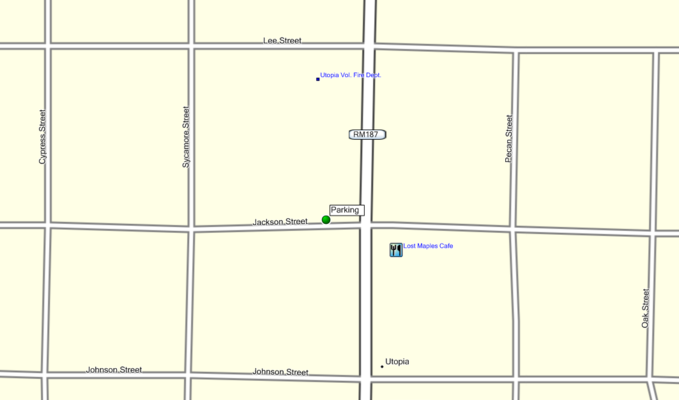
Lost Maples Cafe
384 FM 187 Main Street
Utopia, Texas
830-966-2221
http://www.lostmaplescafe.com/
Post Breakfast Ride Information
If anyone is up for a post breakfast ride see the optional route map below.
The route is a no host self-guided GPS ride, as the ride is self-guided
join a group or lead one.
The post Adventure Breakfast rides are all about fun, camaraderie, being safe and
forming riding groups so no one rides alone, especially on back roads. Some groups will focus on completing the route, others will just relax and ride to their cut off time then break off and head home.
*You determine your start time, groups usually take off before 10am.
A
group size of 4 - 6 ride is optimal, with about a maximum of 8, grouping by bike size or desired pace is also beneficial if possible.
Rain date information will be posted on the Thursday before the ride if necessary.
Route information & Map
*Disclaimer - I build the routes on my computer using the Roads of Texas map book as my guide which is the best and most accurate I have used, but not perfect, and Google maps. So the route may not be 100% accurate. I do not pre-ride the route, it's an adventure for me also. Road closures, legal status, conditions and routing of county roads can change. If in doubt, turn around and find another route -
DO NOT trespass. If a landowner says you are on private property,
don't argue, politely ask for directions to get back to a public road.
What to expect on the route.
Adventure Rider Breakfast Series - 3/17/18 @ 9a Lost Maples Cafe in Utopia - TARA/SA http://www.twtex.com/forums/showthread.php?t=116742 #AdventureRiderBreak...

www.youtube.com
and maybe
Ride 246 miles, gas is available in Camp Wood, Rocksprings and Leakey.
View attachment 64905
For those that want to use a roll chart:
384 Ranch Rd 187, Utopia, TX 78884, USA
View attachment 64911
Head
west on
Jackson St toward
Main St
85 ft
Turn
left at the 1st cross street onto
Main St
928 ft
Turn
right at the 3rd cross street onto
Houston St
456 ft
Houston St turns
left and becomes
FM 1050 W/
Recreational Rd 1050 Continue to follow FM 1050 W
13.5 mi
Turn
right onto
Ranch Rd 2748
2.06 mi
Turn
right onto
Ranch Rd 1120
6.17 mi
Turn
right onto
US-83 N/
Market St
0.654 mi
Turn
left onto
6th St/
Ranch Rd 337 W Continue to follow Ranch Rd 337 W
21.0 mi
Turn
right onto
TX-55 N/
Nueces St Continue to follow TX-55 N
4.14 mi
Turn
left onto
Church St
942 ft
Continue onto
Spring Creek Rd
1.97 mi
Continue straight onto
Co Rd 24
4.18 mi
Turn
left onto
Cedar Creek Rd
11.6 mi
Turn
right onto
White Mountain Rd
14.7 mi
Turn
left
1,280 ft
Turn
right
0.408 mi
Turn
right onto
Co Rd 310
3.03 mi
Turn
left onto
TX-55 N
4.91 mi
Continue onto
US-377 N
7.87 mi
Turn
right onto
TX-41 E
11.5 mi
Turn
right onto
Hackberry Rd
13.0 mi
Continue onto
Co Rd 18
807 ft
Turn
right onto
Hackberry Rd
1.10 mi
Turn
left onto
Ranch Rd 335
5.31 mi
Turn
left
1.34 mi
Turn
right
1.62 mi
Sharp
left onto
Ranch Rd 2631
6.14 mi
Continue onto
Satterfield Rd
2.52 mi
Satterfield Rd turns slightly
left and becomes
Bullhead Rd
5.67 mi
Turn
right onto
Ranch Rd 3235
2.00 mi
Turn
right
1.99 mi
Turn
left onto
Bushong Rd
1.87 mi
Turn
right onto
Ranch Rd 336 S
16.5 mi
Merge onto
US-83 S/
Market St
0.979 mi
Turn
left onto
6th St/
Ranch Rd 337 E Continue to follow Ranch Rd 337 E
10.9 mi
Turn
right onto
Lower Sabinal River Rd
3.93 mi
Continue onto
W Sabinal Rd
4.99 mi
Turn
left onto
Ranch Rd 187
213 ft
Slight
left to stay on
Ranch Rd 187
1.29 mi
Turn
right onto
B and R Rd
3.62 mi
Turn
right onto
N Little Creek Rd
1.33 mi
Turn
left onto
Farm to Market Rd 470/
Ranch Rd 470
5.13 mi
Turn
right onto
S Seco Creek Rd
2.96 mi
Continue onto
Seco Valley Rd
1.38 mi
Continue onto
Co Rd 111
4.77 mi
Turn
left onto
Co Rd 211
823 ft
Turn
right to stay on
Co Rd 211
10.2 mi
Turn
left onto
Co Rd 121
3.54 mi
Continue onto
Ross Rd
2.37 mi
Turn
left onto
FM 462 N
0.909 mi
Turn
right at the 1st cross street onto
Farm to Market Rd 470/
Ranch Rd 470
3.79 mi
Turn
left onto
Kyle Ranch Rd
1.18 mi
Continue straight
0.394 mi
Merge onto
Kyle Ranch Rd
2.53 mi
Turn
right onto
Winans Creek Rd
2.82 mi
Turn
right onto
TX-16 S
3.12 mi
Turn
right onto
Farm to Market Rd 470/
Ranch Rd 470
1.26 mi
Turn
left onto
Schmidtke Rd
1.36 mi
Turn
left to stay on
Schmidtke Rd
2.68 mi
Turn
left onto
Pecan St Destination will be on the left
0.433 mi
View attachment 64909
1111 Pecan St, Pipe Creek, TX 78063, USA
Ride plan & Rider etiquette
For those that join my group - When I lead a group I don’t stop for lunch in a restaurant, I'm in the office all week so when I'm on a ride I want to spend as much time as possible in nature. I plan a stop about midway out in the country for snacks or a sandwich I bring with me, then of course there are the planned fuel stops.
I stop at every corner without a clear / obvious direction to continue and wait for the entire group to make sure the last rider sees the proper way to go,
there is NEVER a need to ride above your comfort level to keep up, if I'm leading I won’t leave you, I encourage riders to spread out to avoid the dust. The
daisy chain method also works well, especially when its extremely dusty to keep the group even more spread out,
the rider in front of the other makes sure the rider behind makes the corner and so on until the sweep rider makes the corner. As long as each rider in front the other takes responsibility for the rider behind no one gets lost.
Please tell someone in the group if your plans change and you decide to break off from the group, that prevents you being searched for.
Road closures, legal status, conditions and routing of county roads is constantly changing. If in doubt, turn around and find another route -
DO NOT trespass. If a landowner says you are on private property,
don't argue, politely ask for directions to get back to a public road.
Safety
AGATT
Having your
emergency contact information on you and having that information readily available is critical. This is important not just for group rides but everyday. Even though you may have a buddy along on the ride you may get separated on the road.
At minimum:
Name
Your street
Your town, state, zip code
Driver's license # & state
Emergency contact
Emergency phone
I taped mine on the bottom of the visor of my dual sport helmet, I also taped another on the back side of my fairing near the dash. The important thing is that it is easy for anyone to find.
Adventure / dual sport roads are disappearing due to pavement or closures, respect landowners and other road users, slow down and ride quietly when passing, people, vehicles, animals, homes, etc.


 Feel free to hang out and lurk as long as you like. However, we would like to encourage you to


 , YEP, what ever it takes to herd the pig down the lane.
