• Welcome to the Two Wheeled Texans community! Feel free to hang out and lurk as long as you like. However, we would like to encourage you to register so that you can join the community and use the numerous features on the site. After registering, don't forget to post up an introduction!

Fathers and Sons Rocking the Smokies! June 15-22, 2019

It wouldnot be a proper TWT photo with out someone peeing in the background 👍

You painted quite the picture of Daniel hitting the ejector seat and shooting off like a frog. The kid probably has those ninja moves anyway. Did your foot slip on the wet ground or were you on a slope? I've had both happen to me...no biggie.
 
It wouldnot be a proper TWT photo with out someone peeing in the background [emoji106]

You painted quite the picture of Daniel hitting the ejector seat and shooting off like a frog. The kid probably has those ninja moves anyway. Did your foot slip on the wet ground or were you on a slope? I've had both happen to me...no biggie.

Slight slope. Tired. Not paying close attention. Gravity storm... [emoji14]
 
Looks like a great adventure so far. Daniel will never forget this trip.
 
So back to day four...

Daniel and I head South on NC 28 into Franklin. We cut through a residential area around the edge of town get over to Old Murphy Road. I love getting off the main streets in little towns in other states. The style of homes is different all over the country. Mostly, the homes tend to be older and not the cookie cutter suburban designs so common around the bigger cities. I much prefer the older homes. They seem far more friendly and inviting, more about having friends and neighbors over to visit on the porch rather than impressing people with how big and expensive your house is.

Anyway, Old Murphy Road wanders next to US 64 for a few miles and then hits Wayah Road, another of my favorites. It follows Wayah Creek and heads out into the Nantahala NF to Nantahala Lake, climbing almost 2000 feet to Wayah Gap at nearly 4200 feet. The woods hug the shoulder of the road on both sides and create a tunnel of branches and leaves. The road is still damp from recent rains and the warmth from the sun peeking through the branches is making wisps of steam rise from the pavement. The last 1000 feet of the climb to the gap gets twisty and tight with a few switchbacks. At the gap there are cars parked along the road and there is some kind of hiking trail nearby that disappears into the woods. A dirt road peels off to the right and climbs into the woods, Wayah Bald Road. Wayah Bald is one of the higher peaks in the area at just over 5300 feet. Daniel and I decide to head up the dirt road to see what we might find. There are other cars going up the road so I figure we'll be fine. It starts out wide, smooth and not to steep. Then it starts getting mucky and slick from all the cars and trucks going up and down it while it is wet. It also starts getting pretty steep. About a mile or so into it and after some slipping and sliding, we decide to just head back to the pavement and continue with the route.

So for years now I have seen a road on the map that I've been wanting to explore, but things have just never worked out where I could work it into a route. We're here now and there's no telling how long it might be before I can get back out here. It's been seven years since the last trip. So I really want to at least check it out. The road is FR 711. As we come down from Wayah Gap, the road is not real curvy and just before it starts to get curvy again, FR 711 heads North. It starts out as a wonderful paved road. We see one truck in an overlook parking lot near the beginning, and then after that, we see no one. The road is really twisty! However, there are a lot of decreasing radius curves and sight lines through the corners are short. That and the fact that we are riding alone makes me keep things sane and relaxing. The road snakes back and forth among numerous peaks, climbing and descending between about 4000 and 4700 feet.

The ONLY picture I take on this road :doh:
238296


After maybe five or six miles, the near perfect pavement ends. A road sign warns of broken pavement ahead. And then just like that, the road takes on a totally different character, feeling like something lost to time and abandoned by road crews and everyone else. Grass grows in cracks. Most of the surface is truly just crumbled up pavement, almost like a gravel road, but the chunks haven't all washed away through years of rains. Occasionally, there are still a few large patches of solid pavement, but they aren't more than a few feet across or a few feet long at most. It doesn't look as if anyone has been through here in a long time. There's nothing out here, like campgrounds or anything else and the road doesn't really go anywhere that might make people want to use it rather than Wayah Road. Daniel seems really fascinated by this particular road and comments on it quite a bit as we are riding. In a few places I dodge a few long hanging branches. Then, we round a corner and spot to KTM adventure bikes heading our way. We wave as they go by. Come to think of it, I think these are some of the only bikes we've seen all week! I've been amazed at how few bikes we've seen on the roads we've been riding, dirt and paved. A moment later we spot what looks like some kind of mid size hunting hound dog with a fluorescent collar. He's just meandering down the road like he knows where he's going and doesn't seem the least bit concerned about us, so we leave him alone. However, a short way down the road we come upon a man walking back up the road and he has a few dogs. So we stop and ask if the dog belongs to him. It doesn't, but he informs us that he will see if he can find it and check the collar to see if there are any tags. A few moments later we come to the end of the road and both of us are commenting about how much we enjoyed this road and wish that Roger and Mason had been here to enjoy it with us. Silently though, I am thinking it was kind of cool that I got to enjoy it just with Daniel and it will always be a cool memory for us. For the life of me, I cannot figure out why we didn't stop and take more pictures!? I think we were just so enchanted with the road and the moment that it totally slipped our minds :doh:

We drop back out onto Wayah Road and head North. My original route plan is to head East on Otter Creek Road which climbs up to Tellico Gap. It then becomes Tellico Road and follows a power line down out of the mountain back toward NC 28. It is mostly dirt and a lot of fun. I've done it several times before, with my 1150 GS and also with my 2005 1200 GS. From there we would run up NC 28 to US 19. This stretch of 28 is awesome, so long as you don't get stuck behind any traffic. It is not about going fast either. It is about flow. The curves just feed one into the other in a fantastic rhythm. The closest thing I can think of to describe it is how slalom racers look coming down a snow covered mountain slicing back and forth through their gates when they settle into a nice smooth flowing motion. I really hate to miss this, but if I cut this out, and the run back down US 19/74 to the Winding Stairs road, that knocks about 36 miles off the route. Daniel is already getting a bit tired, as am I, and it is getting on in the afternoon. I don't want to be getting in late this evening because we have a prepared dinner waiting for us that is to be served at 6:30pm.

Just beyond Otter Creek Road is Winding Stairs Road. This is paved. It snakes its way up and around the East side of Wykle Hill to Queens Creek and Camp Branch Road. The pavement continues on Camp Branch Road and Winding Stairs becomes dirt. As we turn off onto the dirt, we are greeted by a lone rider on a DRZ 400 that stops to chat. He informs us that the road ahead is closed because of downed trees that are on power lines. The Duke Energy folks are currently down there working on it and they turned him around. Well... dang! Two trips in a row now I have tried to ride this road and it has been closed. It is not long or epic. It is just really cool because it very quickly drops about 1000 feet down into the valley below and the road is sharply cut into the side of the mountain, forming a ledge. At the bottom it crosses an old bridge across the Nantahala River to US 19/74. I ask the rider if he's on Advrider and he tells us his name is Bullet87 but he doesn't get on there much. He's a local and just rides all over the place out here by himself. He starts telling me about lots of great roads in the area, many of which I've managed to ride over the years, and we tell him about having just come up 711. He nods that knowing nod and agrees that 711 is a fun ride. We say good bye and he heads off on Winding Stairs Road while Daniel and I run down the mountain on Camp Branch Road. The last little bit of it before we get back down to Wayah Road is really fun!

Now, we could just hit US 19 and run back up to 28, then head North a short bit on 28 to get to the Iron Horse Lodge and join Roger and Mason... Or not... I know Daniel is tired and it's getting hot, but it's not every day that you get to ride in a place like this and it pains me to cut a day short without a really good reason! Daniel informs me that he needs a restroom break. So I tell him the nearest town is Robbinsville and that it is essentially on our way. I also let him know there is a Wendy's there, or at least there was the last time I came through here. So we'll head there for a break. We make a short run down US 19 to US 129, the same US 129 that runs through the infamous Deals Gap, or "Tail of the Dragon". The highway follows Talulah Creek and lazily winds its way through a long valley to Robbinsville. Here, we stop for a break. After a Frosty and a chance to sit inside and cool off, Daniel is MUCH more receptive to the idea of continuing to ride. Even he realizes that it would be a shame to the THIS close to Deals Gap and then not ride it!

That issue settled, we head out of town on 129 following the Cheoah River through the Nantahal NF. The road is just a nice smooth series of big sweepers with the occasional semi tight corner thrown in to make sure you are paying attention. When it crosses the Little Tennessee River at the Cheoah Dam, it makes a sharp turn to the right and then follows the edge of Cheoah Lake a short bit before making a fairly steep and tight climb up to The Crossroads of Time (or at least that is what it used to be called before it got commercialized over the last 15 years or so). NC 28 and US 29 meet right here. It used to be a seedy old motel with a little gas station and an old mobile home where the guys working the place lived. Somewhere along the way, the owner sold out and the new people really began marketing the whole "Tail of the Dragon" thing. Also, a guy calling himself Killboy started taking pictures of riders as they came through the gap and posting them on his website, Killboy.com. You could then go and look up your pictures, and if you liked them, you could order copies. When I stayed here back around 2002, I was the ONLY person here that night. The guys that worked here took me into town to have dinner with them and then we hung out drinking a few beers for the rest of the evening. When they found out I was going to have to ride all the way to Waynesville to get a rear tire for my VFR, they immediately told me they could hook me up and they would sell me the tire cheaper and not charge me for installing it! That literally saved me from wasting a day of riding just to deal with the tire issue!

Anyway...

Now there is a big store selling all kinds of stuff, a nice grill, a big porch, a much improved parking area with places to work on your bikes. And of course, there is still the Tree of Shame, where people hang parts of bikes they crash on the Dragon. The rooms of the old hotel have been renovated and are much nicer now. There is also some other business across the highway cashing in on the notoriety of the road.

So Daniel is pretty excited now. We pull into the parking lot to take a shot of him with the sign.
238302


After the picture, we head up Wheelie Hill and through a few tight corners to the Tennessee state line, which is where Deals Gap is actually located. There is a new sign I've never seen before that makes note of the fact that this stretch of road has a higher than normal accident rate... Daniel points it out as we lean into a corner. Almost immediately we get stuck behind a lady on a SLOW moving cruiser. It rapidly becomes apparent that she really has no idea how to make her bike corner properly. It is painful to watch as she moves her body all over the place rather than just pushing on the bars. On the right corners, she often comes close to dropping off the inside edge of the pavement. On the left handers, she often cuts FAR across the double yellow into the other lane because she can't hold her line. I drop way back and don't even think about trying to pass her. I take a few moments to talk to Daniel about how she could be a totally new rider, scared out of her wits because she is in over her head, and how I really don't want to be the person that makes her stressed more than she is and causes her to have an accident. I don't want to be "That guy" that just ruins her whole ride and potentially sours her on riding or against riders of other kinds of bikes. Barely a few minutes after this conversation, a line of sport bikes comes up behind us. Knowing what is coming, I just pull FAR right as I can and motion them around... Sure enough, they get on the back of the lady on the cruiser and have little patience with her, passing her when they really shouldn't because they simply cannot see if there is on coming traffic!! This is one of the reasons I am not wild about this road and prefer to visit during the week instead of on weekends when it is REALLY busy. All eight or nine of them blow around her and I can tell it has rattled her a bit because she slows down even more :eek2: There actually numerous paved pull out areas along the road on both sides for letting people pass, but she never uses any of them :shrug:

A few shots of the not so twisty sections, both of which have the paved pull outs.
238306


238307


So most folks don't actually run the whole route. The "Tail of the Dragon" is technically 318 curves in 11 miles. There are mile posts on the side of the road. Maybe two thirds of the way into it, there is a pull out for an over look with parking on both sides of the road. Many people turn around here and head back. Fortunately, the lady on the cruiser realizes we've been behind her all this time and she pulls out to wave us past. Daniel gives her a big wave as we go on by and continue down the mountain until the road levels out and starts to follow the edge of Chilhowee Lake. Some folks continue to the Foothills Parkway, which turns back to the Northeast and gets you to the North side of the Great Smoky Mountains NP. If you like twisty roads, it is boring. If you like lazy meandering roads ridden at a leisurely pace, it is great. I prefer to stop at a rest area on the lake.

Just one part of a very large lake formed by one of the MANY dams on the MANY rivers in this area built during the Great Electrification of the Tennessee River Valley under FDR in the 30s and 40s.
238308


238309


238310


The water is very clear and we can see fish swimming around below us.
238311


238312


There is a guy sitting at one of the covered picnic tables by the trees and he has a little 250 thumper of some kind. It looks like a Honda because of the colors, but I think it is some kind of Chinese bike. I spend a few minutes visiting with him while Daniel does whatever it is he does when he gets around creeks, rivers, lakes, and trees... He looks to be in his mid to late sixties and informs me that he has lived in this area his whole life. He's hunted and fished all around here. He and his friends rode dirt bikes on trails all over the mountains. He gets a kind of far away look for a few moments and then mentions that he has truly been blessed to have had all those experiences and to have lived here. "I've had a great life!" It is nice to see someone that appreciates what they've have and had. It's getting hot and I'm itching to get back on the bike. We also still have a ways to go to get to the Lodge into time for dinner. It's already 5:00pm. As I head back over to the bike and gather up Daniel, the guy follows me and continues talking. He's interested in the GS and starts asking me questions about it. He likes it but tells me he doesn't think he could deal with the size and weight. His 250 is just right. As we are gearing up, the lady on the cruiser finally comes rumbling along. She spots us and gives us a VERY enthusiastic wave as she goes past us. I guess she appreciated my not crowding, pushing or passing her. We say our goodbyes to the older guy and head back toward the Crossroads.

This time, we have a clear road ahead of us. So I decide to pick up the pace a bit and have a little fun. We make short work of the climb from the lake back up to the overlook parking area. From there, there really isn't much change in elevation of the road. It is just really twisty with a lot of 180 degree corners. On the out bound run we had spotted several of the photography people in a few corners. Heading back, I'm not really thinking about them because I am focused on the road and on getting to the Lodge in time for dinner. Daniel points them out and asks me if I want to do a few passes to see if they can get any decent shots of us. Okay, we're here, why not? So we turn around and have a go at it, me being mindful of the MANY pictures I have seen over the years of riders coming into the corners, waving and looking at the photographers instead of the road, and then promptly crashing because they aren't looking where they are going or they are going WAY faster than they ought to be. I don't want to be one of those people!

With a few quick passes done, we make the run for the store at the start of the road. We pull into the parking lot and park in front of the porch. Daniel wants to get a dragon sticker for his helmet. As we are getting off the bike, he asks me what the nasty smell is that is coming from the bike!? A quick sniff confirms is the smell of hot brakes and rubber. The weight of the GS on these tires going hard into corners and running at serious lean angles generates some serious friction on the tires. I am still concerned that the rear Shinko 805 might not make it the next few days... It's not quite down to the wear bar yet, but it is getting close. A nice change is that the ENTIRE profile of the tire is getting used up rather than just a flat strip down the center of the tire as happens back home :mrgreen:

238313


238314


238315


Inside the store, Daniel starts looking over the stickers. He sees a few colors that he really likes, but then settles on the day-glo yellow? I ask him why and he mentions that it is currently Rachel's (his younger sister) favorite color and she also uses the same helmet when she gets to ride with me... He spends his days annoying the crap out of her and then has the presence of mind to be thinking about her at a time like this. There's hope for this boy yet! He also spots that they have a display of sunglasses that are the kind I like. They are almost like goggles, with rims of foam around the inside of the lens frames to help keep out dirt, dust, and sometimes bugs. They also have clear ones! After this morning's ride in the rain and fog where I couldn't see, I am thinking having a clear set would be nice for when I don't want the dark glasses so I can see and still want my visor up. So I grab a pair. We pay for out stuff and head back out to the bike.

The run down 28 toward Fontana Lake is really nice. The road drops down the mountain and follows the edge of Lake Cheoah. As we get closer to the bridge that crosses the lake near the Fontana Dam, there is a lot of thick white mist hanging right above the surface of the water. If you were in a canoe, you might have a hard time seeing which way to go. It only rises a few feet off the water though. Daniel thinks it is pretty cool. I have to agree. Once across the bridge, 20 gets nice and twisty with really smooth pavement. Unfortunately, we get stuck behind a relatively slow moving truck. There really aren't many places to pass without being obnoxious about it. The few times we reach a place to pass, there always seems to be someone coming the other way. So there's nothing to do but settle in and just enjoy the ride. The droning of the bike and the hum of the knobbies on the pavement are a kind of mental white noise for me. Some folks like to listen to music when they ride. Not me. I just Zen out to the sounds and the movement of the bike. I find that it helps me find my groove whether I am going fast or slow.

We soon reach the "town" of Stecoah and turn North on Lower Stecoah Road. From here, we just follow the signs until we pull into the parking lot of the Iron Horse Lodge to find Roger and Mason sitting on the porch....

[To be continued...]
 
Okay, let me see if I can get day four finished up...

So Daniel and I gei ourselves checked in and get our gear into the cabin. The cabin has two rooms on each side of the building and the rooms on each side share a common bathroom. It is a pretty nice setup if you know the people in the other room. If you don't, they do have some cabins with private bathrooms. The rooms are not large, basically enough space for us to walk around and between the two single sized beds and for our gear. The bathroom is nice and the water hot. Our cabin is just across a nice creek from the main club house, for lack of a better word, where people can hang out and meals are served. To day that Daniel likes this place is an understatement! After riding around the last few days and seeing all the homes with really cool creeks running through their yards, now he finally gets to play in one! We made it in time for dinner and it was great. I had the pecan crusted trout and Daniel had the grilled chicken breast. If you want meals, you have to let them know before you arrive. I recommend it as the nearest place to eat is probably Robbinsville and that will mean getting back on the bikes to ride over and back. After eating, we just spend the evening hanging out and relaxing. So here are a mess load of pics of the place.

Yamaha Niken parked out in front of the main office, very cool!
238506


238508


A long covered front porch on the main building where you can hang out and meet other riders
238509


First come, first served covered parking
238510


Beautiful new Goldwing
238511


Goldwing Trike, but I don't know if the two riders go with each other
238512


Sweet Indian! Not my thing, but still pretty.
238513


A classic! The Suzuki GS 500E, maybe circa 2001-2005? Snoopster here on TWT had this exact bike as her first bike. A great starter bike!
238514


Our cabin is directly behind the one shown here, but our rooms faced away from the creek and had no porch. The other two rooms in our cabin faced the creek and had a nice porch like this one.
238515


They had quite a bit of tent camping space and more covered parking on the far side of the creek from the main building
238543


The back of the main building. A large porch runs the full length of the building. They got a good fire going just before dark.
238516


Daniel wanted to wander around, so I followed him...
238517


The cabin on the left is ours
238518


238520


It is moving faster than he thought and it is slick!
238523


IF there is water, he HAS to throw stuff in it! Rocks, sticks, whatever he can find...
238522


Main building is out of the shot on the left
238521


There is also a nice little lake right near the creek (notice the ripples on what had until moments before been a glass smooth surface :-P )
238524


Cool hardware, no doubt used to move rocks into place to line the creek through the property
238525


Mason watches Daniel and laughs because he can't remember being like Daniel. Roger watches BOTH and laughs because Mason was just like Daniel!
238526


Looking for skipping rocks
238527


238528


He's determined to skip rocks upstream on rapids... Occasionally, he actually gets one to skip more than two or three times before it plows into a rapid
238529


Looks like old board walks, but I don't think they actually go anywhere now.
238530


We are on the backside with no porch, not really a big deal though as the porch on the main building is so close
238531


I decide it is time to relax...
238532


Moments before I sat down to stick my feet in the water some older guy walks behind me toward the tent camping area and makes a joke about watching out for the water snakes so I don't get bit. No sooner than the words had left his mouth did a large water snake come slithering out from some of the rocks just upstream of me where Daniel was moving rocks around :eek2: A lady standing on the other side of the creek, a good fifteen feet from the snake and in absolutely NO danger starts wigging out :lol2: I just pulled my feet out of the water and watched as the snake swam with the current until it was a good twenty feet or so down stream from me and then put my feet back in the water. I never saw it again. Come to think of it, I never saw the lady again either! :-P Daniel keeps doing what Daniel does...

He wants to use the cold water to chill his drink
238533


So he piles some rocks up to hold it in place
238535


The snake appeared a few feet up stream from me on the same side I am on, but the current was too much for it and it was swept well past me.
238536


Despite a nasty start to the day in rain and fog, the last half of the day after Daniel and I split from Roger and Mason was awesome. It is shaping up to be an incredible evening!


It eventually starts to get dark and the fire flies come out. From this point on, keeping track of Daniel becomes an exercise in futility even though I have repeatedly told him he needs to stay where I can see him. I think he takes that to mean anywhere he can see me :doh: So every couple of minutes I have to try to figure out where it has gone.

Look closely and you should be able to see quite a few fire flies here, and this is only a small fraction of them!

The area has some cool lights to help people see once it gets dark
238537


He was using this stick to swat fire flies across the night sky :doh: We were watching him and we'd see little green streaks go flying away from him!
238538


The Tomball Hillbillies... :-P
238539


I surprised them with a flash :lol2:
238540


After a few beers and the fire flies had fled in terror from Daniel, we decided to call it a day and head to the cabin.

There were two hair dryers in the bathroom that become our glove, sock and boot dryers.
238541


Daniel looking through his pictures from the last few days
238542


In really only have one negative thing to say about our stay here. The pillows are INSANELY thick!! I don't understand why so many hotels have really thick pillows. Occasionally, I will find a hotel that has both thick and thin pillows so you can choose or mix and match. I get that some people like really thick pillows. But I can stand a pillow that jams my chin into my chest or make my ears touch my shoulders when I sleep on my side. These pillows were thicker than even those found at most hotels. I eventually used that blanket on the foot of the bed where Daniel is laying and stuck it inside a pillow case. That worked pretty well and I was actually able to get a pretty good night of sleep. I do like the fact that they had the extra blankets because my feet often get cold at night.

Total miles for the day was only about 218, but it felt like a LOT more...
 
Big 10-4 on the pillow talk. I was imagining the sounds until you included the clips. Seems like those are open windows behind the guys, so no AC required? Nice
 
Big 10-4 on the pillow talk. I was imagining the sounds until you included the clips. Seems like those are open windows behind the guys, so no AC required? Nice

The open windows behind Roger and Mason are on the back porch of the main building, not the cabins. That is the kitchen area behind them. The cabins had window units punched through the walls. You can see them here,

t5101476-jpg.jpg


They worked quite well for cooling the cabin. I don't know about heating, but I likely would not be staying there any time it got cold enough to really need heating.
 
[GPX file for day five is at the end of this post]

Okay, so day five, Thursday. Impending weather is iffy... It looks nice outside when I come out of the cabin to go get breakfast at the main building. It's a good breakfast. Then I head back to the cabin for a hot shower and to gear up. During breakfast we decided to change the plans for today and head back up to Deals Gap so Mason can check that off his been there done that list. I'm hoping it won't be crowded since it is a Thursday morning. We get checked out and get on the road, heading back up NC 28 to the Crossroads of Time (do they still call it that?).

The run up NC 28 is a really nice ride. There are some damp spots but otherwise the road is fantastic. With no traffic in front of us we can run a nice pace, meaning not crazy, but smooth and without causing any unexpected adrenaline spikes :-P I have tried to train myself over the years to pay attention to my heart rate when I am riding. If it starts going up and I am riding on pavement, that means I probably ought to take things down a notch. If we are off the pavement, it probably means I need to hang on and give the bike some more gas! It doesn't take long to reach the parking lot at the Deals Gap Resort. There are some folks here, but it is by no means crowded. Nice. We stop to do a quick walk around the parking lot and check out the hardware.

The infamous "Tree of Shame". Crash on the Dragon and you are supposed to leave a memorial piece of the bike. Unfortunately, there are numerous memorials to riders that never came back from the ride... :zen:
238775


238776


238777


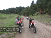
Not much ground clearance for cornering! :eek2:
238778


238779


While checking out the bikes I start talking with some guys that are staying here and they let me check out their room. They have one of the "suites", which is basically two rooms with a tiny kitchenette and a bathroom. The rooms I've stayed in years ago were just one room with two bunk beds and a bathroom. The rooms do look like they've had a decent face lift since I stayed here back around 2002-2003. I think I payed $40/night at the time. I did not check to see what the current rates are, but I suspect they have gone up a bit.

Not my style, but I love the paint jobs I see on these bikes! Notice the wet ground...
238780


The obligatory sign shot before we load up and head out.
238781


Notice that Mason is wearing his rain gear. He's hoping that will keep it from raining...
238821


238782


And with that we head out...

238783


238784


We make the run all the way down to the lake again before turning around to make the run back through. We had a bit of traffic on the outbound run. Heading back, I pull over at the overlook and Roger and Mason go on past us. I slot in behind them. Roger must be feeling frisky because he is moving at a pretty good clip on the 690! Mason is hanging right there with him, nice and smooth. We make it most of the way back without getting caught behind any traffic. Because of this change in plans, it is already getting late in the morning. Today's route would have only been around 200 miles, but this little side trip has added a good hour and a half or more to the ride if we do the whole route. We get back to the beginning and head down US 129 toward Robbinsville.

A quick stop at the dam at the bottom of the mountain again...
238785


238786


238787


238788


Remnants of the original highway I guess... They kind of look like submarine conning towers.
238789


238790


Daniel is calling the shots :-P
238791


238792


238793


We get rolling again. Time is wasting!

This place has really gone upscale since I originally came out here! It is not far from the bridge/dam. The big "feature" of this place was that it was one of the few places you could stay that sold alcohol.
238794


OLD water line that crosses US 129. I make my living designing leak sealing clamps for piping systems. Let me just say, they don't make them like this much any more! I'd be interested to know the history of this line.
238795


238796


We pick up NC 143 in Robbinsville and head West out of town. It is a nice twisty road with no shoulders to speak of in many places. The trees often come right up to the edge of the road. In some of the corners they are cut back a bit more. Where it cuts into the sides of the mountains, there is often a small "ditch" between the edge of the pavement and a rock face, about the width of a VFR 800. DAMHIK... :doh: It eventually brings us to the start of the Cherohala Skyway.

238797


238798


238799


Notice that little note there in the lower right corner of the sign? Basically it means a lot of motorcycles crash here... kind of like Deals Gap :doh: Neither road is that technically challenging unless you are trying to ride them really fast to impress people. Even at well above the posted limit, it is not that challenging. There are some decreasing radius curves, which aren't too bad unless you are over cooking or you just don't know how to lean your bike and roll through them. You might also notice those grey clouds behind the sign... Yeah, they are getting dark and seem to be heading in our general direction. I take this time to switch to my rain gloves and Daniel decides it is time for his rain jacket. With the increase in elevation and the lack of sunlight, it is actually starting to get pretty cool.

The Parkway starts out in North Carolina and then at the Tennessee state line it becomes TN 165. We start climbing from around 2700 feet and eventually get up around 5400 feet just before the state line near Mud Gap. The rain hits and then the fog. Soon we are crawling and I can barely even see the road. Once again my helmet is the biggest problem and it is driving me nuts! I have never had a helmet this bad in the rain! It reaches the point where I am only moving at about 15-20mph with my hazard lights flashing. Several times a car comes out of the fog towards us and it is not until they are almost right in front of us that I can even see their headlights! I am not having fun. The thought of some cager blasting up from behind us and hitting one of us looms large in my mind. I am not having much luck with this road. We had to turn around on our last trip out here because we encountered high wind, heavy rain, and a load of lightning! We never even made it to the state line that time before we high tailed back to our base at Balsam Grove on NC 215 South of the BRP. We can't do that today, but I am hoping we can make it to our turn off onto dirt a little further up the road and get down into the woods where the fog is not usually so bad and there is less traffic to worry about.

We continue slowly making our way forward and it gets cold, like down around 55 F according to my bike's thermometer. Not exactly what a Texan expects in June :-P We pass a few more cars and eventually a long train of wet and miserable looking cruiser riders heading East. About 10 miles or so past the state line we reach our turn, FR 345, which also becomes Citico Road. It is a nice paved road down through the woods. It is still wet and foggy, but it is getting better. It runs NE along the side of a ridge line. We soon reach a bunch of switchbacks that drop us further down into a valley below where we eventually find Double Camp Creek Road. This is dirt and climbs up the Double Creek valley from 1500 ft to just over 2800 ft at Farr Gap where it makes a turn back to the West and continues climbing to about 3100 ft before starting to wind back down the other side of the valley.

I think this is Cold Spring Road following Jake Best Creek as it flows back down to Citico Road and Citico Creek.
238800


Once of the nicest dirt/gravel road you will ever find, even when it is wet!
238801


A lot of these forest roads start out real nice as you ride by places like campgrounds and other areas where people come frequently. Then they usually keep going and once you get past those area, the quality of the road often degrades in terms of how well maintained it may be. Of course, whether or not this is "degrading" or improving may be a question of perspective :-P They will usually have some fun challenging sections where the surface is rougher and I have to pay more attention to the lines I might pick when going up or down steep sections. But then after a while they will usually return to an area that obviously sees more traffic and it will go back to being well maintained again. This loop we are doing has been much the same, but it never gets to the point where I question whether I really want to keep going while riding two up on the GS.

Roger waiting for Mason to bring up the rear
238806


Once again, Mason's rain gear has not been up to the task and he's a bit soggy, so not super happy.
238802


238803


238804


Most of the water you see on my visor is on the INSIDE... Those are the clear glasses I picked up at the store at Deal's Gap last night when Daniel and I stopped there. At least with them, I can ride with the visor up and have some chance of seeing, but even they get a good bit of water on them. At least the fog is no longer an issue.
238805


Once back to Citico Road, we are back on pavement. It continues following the creek a ways. The pavement gets more and more narrow and bumpy, as in the ground below the pavement subsiding in the outer half of the lanes. There are also a lot of large tar patches and tar snakes everywhere. I keep the pace pretty mellow and brake early for every corner, going easy on the gas coming out of them. Even still, I manage to have the rear slide around as we are coming down a hill into a right right hand corner. I am barely even on the brakes, and even with the ABS, the rear still slides on the tar. Fortunately, we are still vertical and the front end stays put so we can lean through the corner without any other issues.

We reach Mount Pleasant Road and head East to make another out and back loop from Citico Road. It is a fun road with lots of fast elevation changes and tight corners. The pavement does start to dry out a bit and the sun starts to peak out from behind the clouds here and there. Of course, now we are down under 1000 ft and the heat is coming back on, as well as the humidity! Citico Road and Mount Pleasant Road follow the edge of the Cherokee NF. We eventually reach the Chillowee Lake not far from where Daniel and I had pulled over on US 129 yesterday and visited with the older gentleman that lived out here all his life. I can see the highway on the far side of the lake. Here we cut back West and eventually pick up Citico Road again. Citico Road turns to the SW and we make a run for TN 360. Daniel is complaining about being hot now so we stop to get rid of the rain gear.

Mason is still tired... Happy to be out of the rain gear, but still soggy...
238807


238808


Happy to get ALL of the rain gear off and vents opened!
238809


The little back roads in this part of Tennessee are no where near as nicely paved as similar roads in North Carolina. Seriously, I've not seen many other states that have roads as well maintained as North Carolina. On the other end of that spectrum is probably Louisiana :-|
238810


Once we reach TN 360, we head South for Tellico Plains. This is a fun paved highway and we can pick up the pace to get some wind flowing through the riding gear! The sun is cooking us now. Just before we reach TN 165 at Tellico Plains, we stop at a little gas station for gas and a break. They have a nice covered eating area outside where we can enjoy our ice cream and Gatorade. Roger and Mason make the decision to call it a day and head up TN 360 to Vonore on US 411, where we will be staying for the night. Mason wants to get into some dry clothes. It is also looking like it might start raining again :doh: It's only about 3:30pm and I REALLY don't want to call it a day. It is obvious we won't be able to complete the whole route, but I am thinking Daniel and I can hit about half of the loop I had planned on the South side of TN 165. Specifically, I want to show him Bald River Falls. I tell Roger not to worry unless we don't show up by 6:00-6:30pm. That should give us time to make a shorter loop and then haul back up TN 360 to Vonore to meet them in time for dinner.

And then we are off...

Daniel and I hop on Tn 165 and head East out of town. The road follows the banks of the Tellico River and soon starts to twist and wind in nice sweepers. Where 165 peels away from the river and starts to climb up to the Cherohala Skyway, we head SE on River Road, which follows the river back up into the woods. It is a nice narrow paved road with trees forming a shaded tunnel, which feels good about now! The falls are a few miles ahead. We just enjoy a nice relaxed pace, checking out numerous smaller falls in the river and cool rock formations.

When he sees a rock wall like this, his urge to climb really kicks into high gear!!
238811


238812


When we reach the falls, there aren't tons of people, which is nice. I have been here when it was really crowded and that takes a LOT of the fun out of it.

238813


238814


While sitting there, we speak with the guy taking the pic for us. He's a local. I mentioned having seen people climbing out onto the upper levels of this water fall the last time I was here. He then informed us that a teenage boy had climbed out onto the falls last year and slipped, landing on that big rock just to the right of Daniel's head in the pic above. It killed him. Then rescue workers had to risk their lives to recover his body... Many of the falls in these areas have signs warning people about the danger of climbing out onto the falls and that people die every year from falling. Every year people ignore those signs and some fall to their death... It is hard to describe just how slick those algae covered rocks can be!! I am hoping Daniel is absorbing this.

Vid from iPhone -- there is a LOT of water coming down those falls and it makes quite a racket!


This was the first attempt at the pic above :lol2:

The water flows under the bridge we are sitting on and joins the Tellico River just on the other side of the road. The amount of water flowing through here really is amazing because the head waters of the Bald River are not that far away. There are a few other feeder creeks that also start in the area. I am guessing they must be some pretty serious springs as this river flows year round at a fairly consistent level. Although, the local tells us about how high the water got under the bridge earlier this year after some REALLY heavy rains over a long period of time. Basically, the lower level of the falls from our shoulders down were submerged!

238815


238816


The climbing urge got the better of him on the way back to the bike :doh:
238817

(He's not out over water, the parking lot is just out of frame at the bottom of this picture :-P )

We get back on the bike and get moving. It is HOT! My original route plan was to keep heading East on River Road and pick up North River Road, which climbs back up to the Skyway at the state line where NC 143 becomes TN 165. Just before the Skyway, we would turn back to the SW on Mud Gap road, which runs back down to the Tellico River and River Road. I drove a Toyota FourRunner out there years ago with Beth and Sarah (when she was 9 months old). It was all unpaved, but I can't really recall much else about it, like how long the loop might take on a bike or how difficult it might be riding two up. So I decide to just lop that section off the route and stick to the River Road until we reach Old Bald River road.

Without even realizing it, we ride right past Old Bald River Road, which ought to be a clue about the road... In fact, we ride right past Mud Gap road, not realizing it was on the other side of the river, accessible by a little bridge that goes over to a fish hatchery facility. Fortunately, not far past Mud Gap road I happened to glance down at the GPS and realized we were moving away from the route on the map! We turned around and found Mud Gap Road. It was a narrow two track trail heading up into the woods. I momentarily pondered riding it up to TN 165 and then running that back down to Tellico Plains, but the fresh memory of the fog and rain on the Skyway was still to fresh in my mind. It also did not look like it saw much traffic. Being alone with Daniel I am a little leery of getting into trouble in the middle of nowhere. So we turn around in the parking lot of the hatchery and head back toward Old Bald River Road, but first a quick pit stop at a camp area that has restrooms.

238818


The beginning of Old Bald River road looked a bit questionable, but after going around a few corners it changed and looked nice.
238819


This will be the last picture I take... We didn't get real far before the road started getting narrower, rutted with erosion from rain run off, steep in places, and there were many places where I was ducking under low over hanging branches... But, it wasn't hard per se... We both noticed that there were at least two fresh sets of tire tracks in the road, so there are people driving through here. Also, in a real pinch, as much fun as it might not be, it would only be a few miles to walk to get back to the River Road if we really had trouble. So we pressed onward.

The road immediately starts climbing, rising over 600 feet in the first mile or so. We pass through an unnamed gap between Sugar Mtn and Maple Camp Lead (another mountain), and the road starts descending down toward the Bald River. We pass another road that would actually take us right up to the head waters of the river. If we had more time it would be fun to head up there and see what we might find, like a big spring just gushing up out of the ground. Not much further past this road, the river turns North away from us and heads back toward the water fall. There is actually a hiking trail that follows the river back through the woods to River Road. We press on and the road starts to climb again, now looking less and less traveled. We climb almost 1000 ft in less than a mile to reach Basin Gap. This is a five way intersection. We continue on our road and it starts getting really twisty, dropping slowly down the side of the mountain above Tobe Creek. About this time Daniel and I both notice that the tire tracks that we had been seeing earlier are gone... :ponder: Well, I can see on the GPS that it is not much further to get back to River Road. At Wildcat Road, Old Bald River Road turns North and wiggles its way down out of the mountains back to River Road. After a few fun switch backs it finally drops us back out onto pavement about half way between the water fall and TN 165. We are both somewhat relieved to be back on the highway, but also admit that Old Bald River Road was a lot of fun and it is too bad Roger and Mason missed it! Daniel even mentioned that it was too bad that both days they cut out early we immediately did something really fun.

The time for fun is mostly over. It is 5:30pm and we need to beat feet to the hotel before Roger starts to get worried about us! Fortunately, it is only about 30 miles or so to get there and it is a nice twisty highway. The pavement is dry. Apparently that almost rain never happened. We make good time and reach the hotel parking lot just after 6:00pm, to find Roger and Mason coming out to go get dinner (NOT worried about us :lol2:). They do at least wait while we drag most of our stuff up to the hotel and then come back down so we can go get some Mexican food with them in town. The restaurant turns out to be REALLY good, The Cielito Lindo Mexican Grill on US 411 a little West of TN 360.

Stuffed, we head back to the hotel. Amazingly, they sell beer at the hotel. Near the check in desk they have a small room with coolers in them. They are locked. All we have to do is let them know what we want and they grab them for us. So we spend a while sitting outside enjoying a really nice evening and watching Daniel chase lightning bugs again. Shortly after dark we head inside and call it a night.

237 miles for myself and Daniel.

One more day... I'm already getting bummed that the trip is almost over :-(

GPX viewer
 

Attachments

  • NC 2019 Day Five.gpx
    2.2 MB · Views: 245
[GPX file for day six is at the end of this post]

Alright then... Day six!

I slept pretty good last night. The bed was comfy and the pillows were sane thicknesses. We met Roger and Mason down stairs for breakfast and got a leisurely start to the day.

The forecast for today is great!
238896


We head out and get back on US 411, heading East just a short bit before turning South on Mountain View Drive. It is a nice narrow paved road that rolls through a rural residential area with really nice homes sitting on hill sides. We turn here and there, just kind of generally heading SW toward TN 68. I could have planned a more scenic route to Tellico Plains, but at this point I am just trying to make miles to get us to the start of the good stuff because it promises to be a relatively long day and almost all of the roads are unknown to me. So I want to leave time for the unexpected. When we reach Tellico Plains, we head East on TN 165 out of town a short ways.

Cool covered bridge over the Tellico River just East of town.
238897


We are looking for Old Furnace Road, which peels off to the SE from TN 165 and heads up into the mountains. It quickly climbs over 800 feet out of the river valley below and becomes a nice graded dirt road.

238898


238899


238900


238901


238902


238903


It gradually turns more to dirt than gravel and begins getting a bit rutted... nothing bad.

238905


238906


Daniel got a kick out of riding under a tree for some reason :lol2:
238907


238908


It doesn't take us long to reach TN 68 where we turn North for a few miles. Just shy of Tellico Plains, the road loops down around the end of a mountain, dropping through some fast and fun sweepers. At the bottom we turn onto Old State Route and start heading SSW, climbing up the backside of the mountain we just came around. Old State Route soon becomes dirt and broken pavement.

238909


238910


238911


No water run off issues here...
238912


238913


Mason has already tagged his Dad's 1190. When I do stuff like that, I call it "pre-inheriting" :-P
238914


238915


238916


We pass Cash Ridge and the road starts dropping down into a small valley
238917


Here we come upon Conasaugua Creek.
238918


I take it right through what looks like a big green patch of grass growing in the water but which is actually a reflection of tree leaves from above
238919


Daniel and I get across without any issue. The bottom is rocks, but no real big ones. Roger and Mason rarely give me time to get setup to shoot video or pics of them coming across. I think it is because they don't want any evidence :-P But, they are learning to wait...

Roger
238922


238923


238924


238925


238920


238921


We don't get very far before we come to another crossing, much like the previous one. I slow to take a look and don't see anything that immediately sets off any alarm bells. So pick a line and we roll through without issue. We wait for Roger and Mason and everyone is across fine. Again, barely even a few minutes later we come to another crossing. I slow again, don't see anything that really grabs my attention other than what looks like a few rocks sticking out of the water, so I go to the left of them...

Daniel gets this shot mere moments before we hit a big rock, lose our momentum and fall to the right...
238926


Water crossings are always a gamble. Ideally, we'd get off our bikes and inspect them very carefully, conferring with one another about the best lines, blah blah blah... If you have been on many adventure rides you realize it rarely goes down like that... until after someone goes down :doh: As we start going over, I am focusing on hitting the kill switch so the engine doesn't suck in any water. As I am doing that, I hear Daniel telling me over the communicator to kill the engine. That's good. Rather than panicking, he's thinking! Instinctively I try to put my right leg out to keep us from going over, only to realize those "rocks" I had seen were actually an entire ledge running across the creek. It is high enough that I don't have a chance to get my leg set and stiff to stop the bike... over we go into the water.

I can feel the cold water gushing right over the top of my water proof boots... which means they keep the water in as well :doh: We both land in the water, but the bike is not on top of us. We rolled off onto the top of the rock ledge and the bike just kind of leaned over against it and stopped. You can get an idea by looking at the pick below. The ledge is just by my right leg and just below the surface of the water where I couldn't see it because of the reflections on the surface of the water.

It is a bit over the axle, so right under a foot deep. I can't get it moving because I am in a bit of a hole. Roger wades into help me walk it out.
238927


You can see here how the left side path looks like the safest... You can't even see the ledge that kept the bike from going all the way down. After two easy crossings in such close proximity to this one (it's even the same creek), I guess I just figured this would be like the others :suicide:
238930


Now the careful consideration and conferring about best lines starts in earnest... Those rocks are algae covered edge trap nightmares!
238928


238929


Mason makes it look easy...

238931


Then comes Roger

Looking back. I came across on the right side of this image.
238932


I was closer to that ledge by the tree. The brightly lit area below that is where the underwater ledge starts. Between that and the upper ledge is where it got deep.
238933


The ledge lower right is what got me, but out there in the middle where it is under water. You can see the underwater part here because the light is not causing reflections that hide it like it does from the other side. You can also see all the wandering edge traps just under the water that make Roger and Mason skip around as they came across.
238934


My feet are where I landed, barely a few inches deep. A few inches in front of my toes is the drop off...
238935


238936


Everyone just chilling for a few minutes
238937


Bike is fine. Guards are scratched, but that is what guards are for :mrgreen:
238938


I sit down and take my boots off, hoping to drain some water. It is an exercise in futility. I wring out my socks, also futile. The lining of the boots is acting like a giant sponge and is holding a ton of water. Well... at least this is the last day and I don't have to deal with soggy boots for several more days of riding! Daniel's feet are soaked as well. No doubt the smell in the hotel room this evening is going to be "fragrant"... Fortunately, we can just stick them in the bike with the trailer when we get to the hotel this evening.

Once on the far side of the creek we immediately start climbing out the other side of the valley. The roads gets quite twisty as it wanders between a few nearby mountain peaks.
238939


238940


We eventually meet Epperson road and head East, briefly getting back on TN 68 and then picking up Joe Brown Highway. This is one of those roads I have been eye balling on the maps for years, wondering if it was paved or dirt, but I'd never managed to work it into a route until now. It heads straight South to a line of mountains that form the state line between Tennessee and North Carolina in the FAR West edge of North Carolina where the slanted part of Tennessee starts. There is a ridge line that actually forms the boundary between the two states and the road passes over the ridge at Unicoi Gap, right at 2000 ft in elevation.

Heading up to Unicoi Gap
238941


238942


Just beyond the Gap
238943


There are quite a few fun switchbacks coming down the far side of the ridge into North Carolina.
238944


But then the road straightens out a bit as it gets near the bottom.
238945


We reach an intersection where Shuler Creek and Burrell Mountain Roads come together with the Joe Brown Highway. We cut back to the SW on Shuler Creek Road. It just wanders around the base of Long Ridge and then comes back around to Joe Brown Highway again after running near the edge of Appalachia Lake. The section that follows Shuler Creek is really fun. It starts out kind of more like a two track trail than an actual road. It is narrow and winding and there are occasional branches that have to be dodged. But it soon opens up and is just a real nice smooth gravel road.
238946


238947


Fast easy riding on nice crunchy loose gravel
238948


We reach Morrow road and cut back toward Appalachia Lake and the road becomes paved.
238949


238950


We quickly reach Joe Brown Highway and head South on Hiwassee Dam Access Road. The road is paved. It is good twisty fun! We soon reach the Hiwassee Dam. Appalachia Lake and Hiwassee Lake are both formed by dams on the Hiwassee River.

We actually get to ride over the top of the dam.
238951


238952


Daniel did not get a picture of it because he was looking back at Roger, but just ahead of the bike in the picture above is what looks like a platform built into the road. It reminds me of the elevators in the flight decks of old WWII aircraft carriers that would just pop up right in the middle of the deck instead of out on the sides. I am guessing that this is an access to the internals of the dam for the over head crane we just passed under. Like virtually all the dams out here, this one is used for power generation. I suspect that this is where heavy equipment goes in and comes out, like turbines, generators, etc,...?

A few miles from the dam we had South on Lower Bear Paw Road. This is another excellent paved road. Once again, the North Carolina road crews don't disappoint! It takes us to the TINY town of Bear Paw on one of the legs of the Hiwassee Lake.
238953


At Bear Paw, we hang a right onto Upper Bear Paw Road and head SW, eventually following Bear Paw Creek until we drop out on NC 294. We head NW to find our next turn.

As often happens on these rides, I blow right past it because I am enjoying the road rather than staring at my GPS...
238954


Our turn is on Candy Mountain Road. As we are making the corner I hear Daniel come on over the communicator, "Oh man! This should be SWEET!"...

He gets it from his Mom, who gets it from her Dad. They all think they are the punniest people around :doh:

But... he's right! :mrgreen:
238955


238956


238957


This is a great road! Alas, it is also not a real long road and we soon come back out on NC 294 right near the state border and we cross back into Tennessee and make a stop at a little gas station on TN 68. I figure Roger needs gas. I am hot and thirsty. Most of us could probably use a restroom break. I need ice cream... It is an old place. At first I am not even sure the pumps work. But, Roger heads inside and finds out they do indeed work. So he and Mason fill up. I grab a Gatorade and an ice cream and head for the bench sitting out front. I take my boots and socks off to let me feet dry out a bit. They are shriveled up like old prunes... I leave my boots sitting upside down while I enjoy my cool refreshments. Daniel befriends the old dog that runs the place. No one gets past the front door without scratching her behind the ears or rubbing her belly!

Relaxing...
238958


We get surrounded by a biker gang! :-P
238961


I don't know why Daniel feels the need to glare in his pictures... :lol2: Everyone is tired and hot. But we are still barely half way through the day! Hmmm... Maybe that is why I am getting those looks :scratch:
238959


[To be continued...]

GPX viewer
 

Attachments

  • NC 2019 Day Six.gpx
    2.1 MB · Views: 210
Last edited:
Right... so let me see if I can get this wrapped up!

After a nice relaxing break at the little country gas station, I put my soggy boots back on and we headed out on TN 68, going north. We quickly reach and cross the Hiwassee River and immediately turn right onto River Road. I am looking for a road that the maps show as Old TN 68. It looks really twisty on the maps and could be fun. River road is dirt and has a LOT of good sized pot holes that almost impossible to miss. I get so focused on trying to dodge them that I don't look at the GPS until we've already pass the turn. I never saw it though. I ask Daniel as he's pretty good about noticing side roads, but he never saw anything either. I stop and motion to the others that we need to turn around. They are getting used to this by now :oops: This time I am putting along and really watching the GPS, but I still never see a road!? I turn around again and go REAL slow, then I see it, two very faint tracks going up a VERY steep incline... It doesn't look like it has seen ANY traffic in years. I point it out to Mason and it doesn't take long to decide we'll pass on this one and just run up the new TN 68 (that has been there for well over 20 years at least). So we head back to the highway and continue North. We're only on the highway for a few miles, but those few miles are really fun, full of great curves.

We hang a left on Ironsburg Road and head into the woods. It brings us to within a half mile or so of where we dropped out on Epperson Road earlier after that nasty water crossing. Ironsburg dead ends into an intersection where Epperson Road goes right and Towee Falls Road goes left. We go left. Some maps show this as Fingerboard Road. It is a nice easy road that just winds through the mountains and woods. Initially it runs a long a ridge line but then turns West and drops down into a creek valley. At the little town of Towee, we turn South on Childers Creek Road. It is quick and mostly straight, running down the edge of a long valley to the small town of Reliance at TN 315. Here we cross back over the Hiwassee River again. As we are crossing, Daniel points out a cool old passenger train that is crossing the river on a different bridge. It has one of those cars with the elevated glass dome on top so people can take in the views.

[I look it up when we got home: https://www.tvrail.com/events-exhibits/rides/hiwassee-loop]

There are a mess load of people on the South side of the river where we turn South on TN 30. I think they are rafters. Most are young, like 30 and under maybe. A short way South of Reliance we pick up the Kimsey Highway. It starts out paved but soon becomes dirt. In the space of a few miles it climbs from around 1000 ft to almost 2400 ft, peaking out at Deep Gap. It is a little more rough than some of the other roads we've been riding. The surface isn't loose gravel like so many of the roads, but instead embedded rocks, which are good for traction but make for a bumpy ride! Daniel is busy holding on and doesn't get any pics. From Deep Gap on, it runs along the sides of a series of peaks and passes through several more gaps along the way. It reaches 3000 feet at Jenkin's Grave Gap (I never saw a grave :shrug: ). At Robinson Gap , we head SE on another section of Old Highway 68, this one clearly used frequently. It quickly drops us down back to the current TN 68 where we head South to Ducktown. My feet are getting HOT in the boots. My soles feel like they are burning, which doesn't normally happen. I assume it is because they are basting in all that water... :argh: We stop on US 64 in town to get gas, snacks, and to take a much needed break. The rain the past few days wasn't always fun, but it did keep things cooler!!

After a nice break, we head West on US 64 a few miles along the Ocoee River until we reach FR 45. We cross the river and head SW into the woods. It quickly becomes dirt and starts getting rough like the Kimsey Highway. It climbs very quickly, reaching 2100 ft at State Rd 221. This wiggles across the north slope of Peavine Mountain then turns to the SW again and gets REALLY twisty. I settle in and try to find a rhythm that matches the endless corners and bumps while trying to maintain a decent pace. We're doing good to average 20mph though. Did I mention my feet feel like they are on fire!? The road seems to go on forever and ever... We eventually come to an intersection where we head South on Big Frog Road. It starts a long climb to the top of a ridge and then follows it West a little ways. I decide to stop for a quick breather and to wait for Roger and Mason to regroup with us. It's been a bit dry and dusty so we've been a bit more spread out than usual.

239288


No idea where this goes or even what road it might be as it isn't on any of my maps...
239289


Sheesh... even out in the middle of NO WHERE! :lol2: Must be a generational thing :-P
239290


After this stop, Daniel decides it is time to take more pictures... The road smooths out considerably!
239291


239292


239293


239294


Heading uphill.. still have to watch for erosion ruts.
239295


239296


Enbedded traction!
239297


239298


One of the few wet spots
239299


239300


239301


A short section where I have to be a little more careful about picking a line, but not difficult at all.
239302


Crunchy!
239303


239304


239305


Right when the road reaches the border between Tennessee and Georgia, it cuts West. and then slowly starts to descend.
239306


239307


A short steep section... Just have to let it roll...

239308


Red clay, but at least it's dry ;-)
239309


A few wet spots, but nothing we can't avoid
239310


239311


239312


Starting to drop down faster
239313


239314


239315


239316


A quick stop to regroup at an intersection
239317


239318


239320


239322


At Simmons Gap the road really starts to drop in elevation pretty quick through a series of switch backs and eventually dumps us out on Sheed Creek Road.
239323


239324


239326


239327


239328


239329


239330


239331


239332


At the bottom we come to a camping area, and I miss my turn... again :lol2: In my defense, the road was covered with pot holes full of muddy water and I was trying to keep from hitting them because it is hard on Daniel sitting back there behind me since he can't really stand very well. I only go a few hundred feet before realizing my error and we get turned around. We head South on Chable Road which crosses over the Jacks River. Now my maps all show that we are about to pick up Old Highway 2 and the color of the lines makes it look like it is not going to be some trail like that first section of Old Hwy 68, but who knows?

As we cross the bridge we also cross back into Georgia from Tennessee for the last time.
239333


Part of Old Highway 2 runs off to the West and hits 411 and the other part heads kind of SE back toward the town of Blue Ridge on US 76. There is this one section though... where the line on the map makes it look like it will be a dirt road that goes all the way through to another section that looks like a regular road. We head that way :mrgreen:

The road turns into essentially a two track gravel road with a good hump in the middle. The gravel is pretty deep too, but the corners aren't real tight and I can get into a nice groove! Daniel decides it is time to stop taking pictures and hang on as we are sliding around in the corners. We barely get a mile into it before we come to a nice water crossing.

I DO slow down and take a good look before heading across, but it is nothing nasty... this time...
239334


Mason tries to keep his feet out of the water on all the water crossings
239335


Everyone gets across without any issues and we are moving again... for about a half mile before we come to another crossing just like the one before.

A little longer than the first maybe...
239336


Waiting on Mason
239337


The road soon becomes mostly that grey gravel.
239338


239339


239340


239341


239342


The road starts to climb a bit and after a few miles we roll into a big open area with a car parked in it... I don't see an exit... :doh: All my maps show the road keeps going, but all we find is a locked gate. I guess the road has been surrendered back to nature. There is one of those trail head poster boards with maps on it and all kinds of don't be an idiot and don't die warnings. Well... I sure don't want to have to backtrack through ALL of the stuff we've been riding the last few hours! Roger and I start looking at our GPSs for an alternate route. My maps still show that section of Old Highway 2 heading West to US 411, but his doesn't. It shows a section of road from that campground back to US 411, which is further North, but only by a few miles. So I tell him to take point.

The run back to the camp ground is a wee bit more spirited than the run out :rider: I can barely keep Roger and Mason in sight. We quickly come back to the second water crossing and I see Mason a hundred feet or so up the road on the other side looking back and waiting for us. I plunge in at about 5-10 mph, not enough to make a wake that splashes up onto us and we get across without issue. BUT...

I took a different line this time, just staying to the right side. As we exit the far side, the road is really soft and loose gravel. Almost immediately the front end of the bike starts flopping all over the place. Instinctively I try to give it a bit of gas to lighten the front end and bring it back under control. Normally this would work... BUT...

The Shinko 805 on the back of the bike has done its best to last the whole trip. I put it on before two days of HARD riding in Arkansas with Daniel, Roger, and a few other TWT guys. That was maybe 580 miles or so? Then I made an impromptu run up to the South Fort Worth area for a BBQ get together at Crew Chief's place. I was in a hurry to get there by the start time, so I was... um... hustling. That was another 380 miles or so. The tire wasn't looking so good when I got home from that. At that point, I hadn't planned on going to North Carolina the very next week or I would have mounted a new tire before leaving. But with only a little over 1000 miles on the tire, I thought surely it could do another 1400 miles or so...!?

It is at this point that the tire lets me know it is pretty much done. I don't get on the gas hard, but apparently I get on it harder than I should and the rear just shoots right out from under us! The bike just spins around and falls to the left in the soft gravel. At this point, we have almost no forward speed at all, so both of us just roll off the side away from the bike. I land on my left knee and then roll over on to my back. I look to my right and Daniel is laying on his back next to me.

"You good?"

"Yep".

"Okay, I am just going to lay here a moment and wait for my adrenaline to come down and see if anything hurts..."

Mason comes running up from the other side of the bike to see if we are okay. He gives me a hand up and we get the bike lifted. All is good.

I entered at that bright spot on the far side. You can see where the rear broke loose and shot around in a big arc.
239343


Moments after we get the bike righted and Mason is remounting his bike, Roger comes zipping back down the road to check on us. When he sees all is well, he tries to spin his bike around and drops it on its left side :lol2: Roger is always FAST when his bike goes down. One of the rare pics I managed to snap on a different trip only has the bike half way down because I couldn't get my camera out fast enough. There's no chance this time. Still... it DID happen! That's the story and I have two witnesses :-P

We get rolling again and quickly reach the next water crossing. We roll through it and exit the other side without any drama. We reach the campsite and head West on Sheeds Creek Road, which is a nice twisty gravel road that soon becomes pavement and reaches US 411 in a few minutes.

And just like that... The fun stuff is done. :-(

We drone down the highway back to Chatsworth and then cut West to Dalton. Time to get the bikes loaded, clean up, and go get dinner!

It is nice to see both trucks and trailers still where we left them and unmolested!

239344


I asked him if it was fun...
239345


He tried, but he couldn't contain it... :lol2:
239346


I have to say, after the trip to Arkansas and now this one, both with Daniel, I LOVE this bike! It just rides and handles so much better than my 07 1200 GS, which was no slouch by any stretch of the imagination!

We get everything loaded, get showered, and meet Roger and Mason for a short walk over to an Outback Steakhouse nearby for dinner. The steak and a big beer REALLY hit the spot. The plan for tomorrow is to get up and leave around 6:00pm, which should put us back home around 5-6pm local time if we don't hit any bad traffic along the way. After dinner we head back to the hotel and call it an evening pretty early. The nasty wet boots and socks are sitting in the trailer, hopefully to dry by the time we get back to Huntsville.

It doesn't take long for Daniel or me to fall asleep!

It was only a 224 mile day, but it was a LONG day!
 
The long drive home...

We get away early as planned, heading up toward Chattanooga to pick up I-75 back down to Birmingham rather than cut back over the mountains on Mason's crazy curvy route that got us here :-P We make great time, running a pretty steady 75 mph all the way back to Texas, except for Shreveport with its god awful roads!! :eek2: Running 75 mph with the trailer I am getting right around 12-13 mpg and have about a 350 mile range, which is far beyond what any of our bladders can do. We don't mess with getting a hotel like we did on the outbound trip. Everyone just wants to get home.

Daniel is worn out and sleeps for a BIG chunk of the drive home
239348


This was Daniel's first "big" trip with me. When Sarah was eleven, I took her on a big week long trip out to New Mexico, Arizona, Utah, and Colorado. Roger was on that trip, as well as Jfink and Toe Jam, both members here on TWT. Sarah had a real blast and Daniel whined all about how unfair it was he couldn't go... even though he was nine at the time :roll: Anyway, this was his turn. He'd already done a solo Arkansas trip with me back in 2017 for a long weekend, then the one we just did this past Memorial Day. He's a very active kid and has a hard time just sitting around with nothing to do. He did okay on day rides and the two Arkansas trips, but I was a little worried about how well he would do with six straight days of riding... :wary:

He did great. He didn't complain too much and usually only at the tail end of the day when I was feeling it too. This is when I'd go into Dad Mode and tell him that sometimes you have to suffer to get the good experiences and a little suffering builds character :-P Once he was finally able to get off the bike each night he was a bit wound up with all the pent up energy. The stay on Wednesday at the Iron Horse Lodge where he could run around, play in the creek, chase lightning bugs, etc,... was great. In the end though, even just sitting on the back of the bike, it took a lot of energy out of him.

Hopefully, this will be one of those experiences he remembers the rest of his life. I hope that when he's old enough I might be able to do like Roger and Mason and do some trips together where he's riding his own bike. I just don't know if I'll be able to keep him in sight... :zen:
 
Man very nice, and cool to ride with your kid. The Iron Horse looked like a great moto spot. Even I could be convinced to ride those roads ;). I did have a moment of confusion when you talked about "accidentally rolling a joint", I thought maybe you'd strayed into Colorado...
 
It doesn't look like it has seen ANY traffic in years. I point it out to Mason and it doesn't take long to decide we'll pass on this one and just run up the new TN 68 (that has been there for well over 20 years at least).
AKA...BANJO TRAC. Aka...GROWERS ROUTE.... Aka WHITE LIGHTNING WAY
 
Great ride and report. The father son thing is definitely cool.

Did Roger have them troubles with his helmet fogging?
 
The better question is whether or not either Roger or Mason took a single picture on this trip!? :-P

Also, even if they don't do a ride report, it might be interesting to hear their thoughts and reflections on the experience... "Oh geez... we're turning around again!? :doh:" :lol2:
 
Thanks for the ride report Scott - been too long since I've been in that area - glad you all made it safely and I enjoyed reading about the journey :thumb:
 
I thought Daniel was the designated tour photographer?


Sent from my iPhone using Tapatalk Pro

Well, he and I traded out. He took pics while we were moving and I tended to take the pics when we were stopped.
 
Thanks for sharing, loved the report.
I admit to being slightly jealous/envious, it just looked like a bunch of fun!
 
Also, even if they don't do a ride report, it might be interesting to hear their thoughts and reflections on the experience... :lol2:
For me, riding in this part of the country can't be beat. The roads in NC compared to AR/MO, are like comparing the TX Hill Country to AR/MO. They are all fun, but to me, one's a little better than the next. And, this time of year the temperatures are perfect. The scenery, especially the canopy of tree's that overhang and cover the roads, is as good as any place I've ridden.

Scott is right in just how taxing 200-plus miles on these roads can be, both mentally and physically. I really have to watch myself toward the end of the day for signs of fatigue that could lead to a mistake, and know when it's time to call it. This was really on my mind on this trip since my son was with us. He's a pretty good rider on the dirt, but that's usually done in one-to-two hour sprints, not at all like all day on a street bike. Although, I think he's really starting to get the hang of picking the right line and riding a good pace on the street as well.

If y'all haven't had the chance to ride this area, I highly recommend the experience.

Oh, and Thanks Scott, for letting me and Mason tag along. It was a Hoot!

The better question is whether or not either Roger or Mason took a single picture on this trip!? :-P

Yes, I did.

All of the following pictures were taken somewhere East of the Mississippi River...

239558


239559


239560


239561


239562


239563


239564


239565


239566


239567
 
Can you email me the full size image for that last shot of me and Daniel on the bike?
 
Back
Top