• Welcome to the Two Wheeled Texans community! Feel free to hang out and lurk as long as you like. However, we would like to encourage you to register so that you can join the community and use the numerous features on the site. After registering, don't forget to post up an introduction!

.

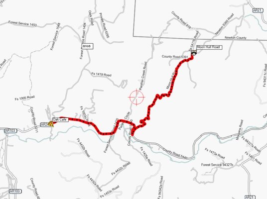
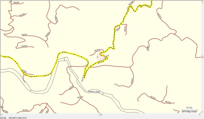
I remember having some growing pains with Basecamp software early on. Overall, I've had success planning interesting routes on rural roads and having these routes install easily, and, not be changed by the 660. It has really been enjoyable using this tool to discover roads I haven't ridden before, and allows me to take the favored back roads to smell the flowers, enjoy the scenery, and avoid traffic.

The Zumo 590 was a complete disappointment.

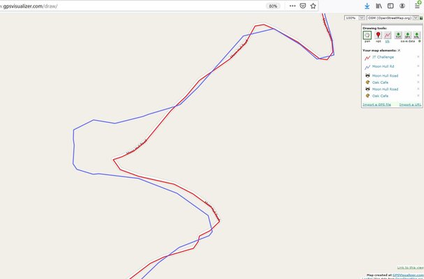
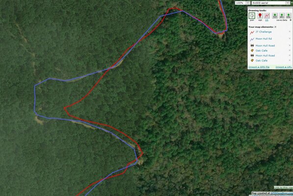
Because these behaviors of rerouting an uploaded route seem to sporadically change from model to model I'm highly motivated to spend hours reading other's experiences with specific use scenarios on any model of GPS before I would consider purchasing it.

Despite its quirks, Basecamp has been the best planning software I've used. It has been a few years since I've experimented with other Navigation software, so that may have changed.

It would be nice to have a small tablet-size device that had mapping, waypoint data for gas, food, lodging, and a PC-based mapping/planning software. My experience with a few of the Android navigation apps has left me unimpressed, as it has been quite a burden to get useful results. These attempts were on an Android HU in a van. I now find myself planning those trips on Basecamp and taking the Zumo 660 along instead.

I was intrigued by Focus Frenzy's TomTom recommendation, until I read that it doesn't support open source maps, and, it being based in the Netherlands, that some reviewers indicate how its US maps aren't as detailed as it EU maps. For anyone traveling primarily on pavement and who has no interest in open source maps, the TomTom looks like a a good choice that is otherwise feature rich.

Bottom line, it is annoying that a consumer has to learn and know so much in order to successfully cull the appropriate model from a manufacturer's lineup. Basic functionality such as importing custom routes as they are should be a no-brainer. Unfortunately, it isn't. Until you have used a GPS and had problems it is challenging to know what to look for when reading forums and reviews to filter out the right model to buy.
 
I agree with the sentiments above. I've also been unable to find a perfect combination for Good GPS tools for street, dirt, etc.

What I think would be pretty great is a product like a TomTom or Garmin motorcycle device with only Android Auto (and I imagine Car Play, though I am unfamiliar with it) and the multitude of mobile apps became available in a glove-friendly, weather-tolerant form factor that always upgrades when I upgrade my phone hardware and software.
 
I've "solved" this problem to lowering my expectations and requirements for what a GPS does. For real rides (as opposed to errands, etc), I plan my route in Google maps, export to KML file, then load onto by phone. It already has offline maps of all the states around here. I get a pretty decent idea of where I'm going in my head - order or towns, any tricky bits with lots of intersections. During the ride, the phone shows the route in blue with a dot for my current location. That's it. I turn the screen on during the tricky bits, but tap to turn off the screen between towns. So, the GPS is there as a gentle reminder where I'm heading, and a way to get unlost when I'm off course. I make some wrong turns, and go out of my way at times, but that's no big deal. I do turn-by-turn navigation with I'm getting from point A to B: finding a specific motel, diner, gas station in an unknown town. I pull over, tap google maps and that's all there is to it. For long rides - I make 'roadbook' paper instructions that I stick in on the top of the tank bag.

It's liberating to not rely on the GPS for every turn and every mile. I get a much better sense of where I am, and what's around me. This took learning, I tried turn-by-turn for every ride when I first got my bike - but the lack of capability made this a real challenge. I'm glad it did.

This is extra-true in places like Big Bend Ranch SP - offline, rough dirt roads that can fan out like a maze, then re-connect, then fan out again. Just put the blue line where you generally want to be, then check after a few intersections and navigational decisions to see if you're still on it. But yes, you gotta be OK back tracking and getting mildly lost from time to time.
 
..It's liberating to not rely on the GPS for every turn and every mile. I get a much better sense of where I am, and what's around me...
^This^.
I remember the first (and last) time I just punched in an address into my phone and followed it to go buy a camera lens off Craigslist, and being quite alarmed when I arrived at my destination not having a clue as to where I was.
 
@Jarrett, I have a Tom Tom 550 that you could borrow and try out. I'm still not used to it as I haven't used it very much yet. Once I can start riding again, I plan to tested it out in your area. From what I got from my Dr, it will still be about a month of physical therapy before I can start riding again.
 
I've used the Montana 600 for years... mostly off road but also in the truck getting to places on pavement. Learning to draw your tracks so they include consistent prompts that are meaningful to you helps a lot. If there's a turn coming up I want to know about it before I get there... not when I'm already there. Having several different maps of an area installed let's you switch around and see way more options for getting from point a to b. Honesty, it's all an art and science with some outright voodoo thrown in but without it I'd be lost as a goose in a hail storm.
 
For the vast majority of my riding, I just pick a random direction after looking at google maps maybe for some curvy roads. I use the gps just for general orientation. The thing that frustrates me is that you have to zoom to a specific range for the names of towns or highways to show up. If the real estate is available on the screen, why not tell me what town is at the intersection of those two roads without zooming in!!!? If I’m on an organized ride, I download the files, but ALWAYS use TRACKS not routes.
 
I'm still learning here but I've come to believe that you can use routes withbturn by turn directions if on a street ride but use tracks if you have any dirt in your loop.

I've had a Zumo 590 for years and been using it for routes on road. Worked great. Almost bought a Montana last month because my 590 sucked off road but then I found out that everyone was just using tracks off road. 590 does tracks pretty well.
 
Do you grab random GPX files, load them on there easily and are able to follow them without any device errors or route hiccups?
I do not. I can, but I wouldn't just grab a random file and throw it into the GPS in hopes that it would work. All those GPX files basically are from my understanding are a sequence of points. If the sequence has a gap that is in just the right place and Garmin's algorithms pick a different route, you can't really blame that on anything. It is just a simple case of two machines talking two different languages, trying to figure out what the other one was doing. And then further complicated with the potential for different user settings from uploaded GPX file and then your settings on your GPS.

I equate the Garmin GPS's to my old YZ250. It would do anything I told it to do without hesitation, and it would do it whether it was really in my best interest or not. Full throttle directly into a tree, you got it. Completely loop out in a whoops section, if I told it to do it, it would do it. It is the same with the Garmin. If I just import someone else's work without checking it, it will get me to those points within the confines of it's parameters that I gave it. If I have it set to "get me there fast" mode and there is a gap in the data, you bet it will take a shortcut down a freeway instead taking the scenic route.

Truthfully, it is pretty easy once you get the hang of the software and how it "thinks".

And remember, if I of all people can figure it out, ANYONE can figure it out. :)
 
I'm still learning here but I've come to believe that you can use routes with turn by turn directions if on a street ride but use tracks if you have any dirt in your loop.

Absolutely positively this! I use turn by turn routes by routes on blacktop and I use tracks for anything that has any dirt in it.
 
So, if a phone app is all you need, map the most direct path from the Oark Cafe, N35.68970 W93.57266, to the North end of Moon Hull Rd, N35.72565 W93.48509. Here is the correct track. Neither Google, OSMAND, nor Garmin can route it correctly. And that's why some of us use tracks.

GPX viewer
 

Attachments

  • moonhull.JPG
    moonhull.JPG
    91.5 KB · Views: 145
  • moonhull.gpx
    66.3 KB · Views: 147
I've also built routes entirely within Garmin apps and had that Garmin app send it to the attached Garmin device and it still does not work.
It won't work at all, or it recalculates the route upon importation into the GPS? If it doesn't work, then I don't know what to tell you without seeing it or asking a bunch more questions. If the GPS recalculates it, that can certainly happen. If Basecamp is set to one set of guidelines and the GPS is set to a different set of guidelines then it can cause some routing issues. Or if you leave too much space/distance between points, a GPS might try to work that solution a little differently.

Don't get me wrong, the software does leave a lot to be desired but once you get the hang of it, it is pretty darn robust and stable.
 
I've also built routes entirely within Garmin apps and had that Garmin app send it to the attached Garmin device and it still does not work.

I get it. A hiking GPS unit with tracks like using a map is the best we've been taught to expect from these devices. I'm just asking for more. Maybe they will deliver one day.

Don't hold your breath! LOL I am still confused on what more you are asking for. If your device takes you where you want to go with out getting lost, or if you do get lost and it helps get you un-lost, what else does it need to do?

Any time I have had an error with a route or track when I went back and looked at it, I have found an error on my part creating it.
 
That app did very well, but it is still based on maps with errors. Here is a screenshot of of the track and the route on OSM which is obviously what your app is running. And here is a ss over the satelite image. Not much error, but OSM is not always this accurate. And the maps used to create the route must match whats used on the device.
 

Attachments

  • Capture4.JPG
    Capture4.JPG
    81 KB · Views: 146
  • Capture5.JPG
    Capture5.JPG
    207.5 KB · Views: 144
Find these roads on a phone app...
 

Attachments

  • Capture6.JPG
    Capture6.JPG
    104.2 KB · Views: 148
and ESRI topo is OSM
 
Back
Top