Feel free to hang out and lurk as long as you like. However, we would like to encourage you to
 “Mexico Otra Vez” (Mexico Again) is appropriate because this covers my third trip South of the Border in the past year. That’s a horse of a different color to those who don’t venture beyond “home”. But birds and monarch butterflies do it, so it was an easy choice for a couple of Texas and Arizona riders during winter. In my case, sit in Austin in the cold, enjoying the Second Annual Austin Pop-up Boil Water Fest, or head south like the birds and butterflies. So, we rode south…waaaay down past Mexico City to the isthmus of Mexico, almost but not quite to Guatemala, where ratcheting between the Gulf and Pacific coasts was slowed by only a mountain range. Along the way there were a few thrills and chills, but no spills…thanks no doubt to highly skilled riders. Or maybe just luck.
The plan was simple: Ride west. Hit Mexico. Turn left and keep going. See countryside, towns, and cities that we hadn’t seen before (as well as some we had). No trucks or trailers were used to haul the bikes to the border; no pre-determined must-sees; no schedule; no BS like “I’m in, but I have to be home by ____”. With fresh tires and maintenance, along with credit and debit cards, there were no constraints. In the end, a short trip for a little exploring turned into 4,000+ miles. No one called to say, “get your #ss home”. No important emails or voicemails pinged me. No urgent bills hit my inbox. Just riding…seeing the sights…and eating…and riding…and thinking. After all that thinking, it became obvious that margaritas are the answer. As for the question - ¿quién sabe?
Each evening, I’d push the button on the SPOT satellite messenger to automatically say “here I am” to family; I might even call home occasionally to hear about the cold weather.
There are a few things about riding a motorcycle in Mexico that are worth explaining. First of all, motorcycles and motorcyclists are not persona non grata, nor frowned upon, nor looked down upon, nor stepped on, lied to, cheated on, and treated like dirt in Mexico (unlike some places I know). The population in general, and other drivers, in particular, often tacitly acknowledge motorcyclists, sometimes treating us as though “we’re special”, and giving us the benefit of the doubt when we’re riding slow, or fast, or looking for our desired direction, or stopping, or “illegally” parking the bikes, or passing a long line of stopped or slow vehicles, or going the wrong way on one-way streets (which we often do), or just exploring the boonies.
If you want to slowly lane split or “filter” to the front of a long traffic jam at a police/military checkpoint or toll booth or construction blockage, no problem - you just ride between the waiting lines of cars/trucks as long as you can without getting squeezed out by 18- or 26- or 32-wheelers (many semis have double trailers) moving closer together as the lanes narrow. My panniers aren’t any wider than my handlebars, are they??? Or you cross in front of another vehicle and work your way to the right edge of the road, then use the shoulder when there’s room. If the roadside ditch isn’t too deep or rough or wet or likely to have hidden obstacles, you may even use it if you’re on a GS. You may also pass a whole line of cars, trucks, and buses slowing and stopping (their normal practice) at the killer speed bumps (“topes”) that protect every town, village, and city street. You just pass the vehicles on the left with the space oncoming drivers give you, or on the right, using the shoulder. A motorcycle generally bounces over a tope with no problem, while a car or truck or bus could be negatively and severely impacted (hence, their stopping). But abrupt topes sometimes surprise even a cautious motorcyclist and give you a very serious, handlebar-wrenching jolt. Wake up call!

TOPE
Overall, drivers in Mexico are very predictable and not out to push you off the road, as you’re apparently not insulting anyone’s manhood by getting past obstacles or ahead of other cars, buses, and trucks (did I mention that’s not like drivers north of the border?).
Navigation can be tricky South of the Border, so you need to muster every resource: A detailed paper map, Garmin GPS, and Google Maps on your phone. Don’t try to go cheap on phone service - spring for an international plan before leaving home. It’ll save your bacon. The compass and common sense can also come in handy. All roads are not necessarily shown on the map, or not necessarily in the position shown on the map, and roads you see may not exist in the GPS data base. On top of that, the GPS may route you in ways you might wish to avoid. For example, at night, over a mountain, on rough dirt roads, with dead ends, through unknown neighborhoods, without any streetlights...we turned around...just to get to the other side of the city. But there is usually a slightly longer, lighted, paved route also. You kinda want to try to make informed choices.
One of the most enjoyable and arguably little known secrets about South of the Border would be “Mexican minutes”. If you’ve ever ridden down toward Central America, you will have experienced them first-hand. However, many adventurers probably haven’t ridden farther south than, say, Beeville or Corpus Christi. If you did, as you get farther and farther south, several factors are at work:

When you’re down there, you quickly adjust and learn to really appreciate the lingering Mexican minutes. Brooks & Dunn captured the essence of this phenomenon in song:
I began the trip by riding west, to Alpine, on a Sunday. If you’ve ever been in Alpine on Sunday evening and are hungry, don’t worry – there’s a gas station for chips and candy. Nothing else. Plus, it rained in Alpine that evening, as I was walking to “dinner”. For goodness’ sake - this is West Texas! Obviously, climate change persists. The next morning, I rode in sunshine to Presidio for the border crossing to Ojinaga, across the Rio Grande. Pretty easy to cross there, no crowds or other vehicles at all on Monday morning. But a US Border Patrol officer who was backtracking across the bridge stopped and lectured me, a taxpayer, law abiding senior citizen, etc., at practically the middle of the Rio Grande bridge, right about where their jurisdiction ends, for riding onto the bridge without stopping at the apparently imaginary exit checkpoint on the US side. First time in my life I’ve ever been told I had to stop at a non-existent exit border checkpoint and talk to a non-existent agent before leaving the country. There was no stop sign or flashing lights or waiting agent or guardhouse or dog or anything telling me to stop, just an orange plastic barrel on the road, which I rode past. I kindly listened to his rude tone of voice for just a moment, then flipped my dark visor closed and rode on to the Mexican side, where they’re nicer. There it was very easy to get the motorcycle permit (I already had my tourist permit from last fall’s trip to Baja). Next, the most important and some might say riskiest stops in town: An ATM for pesos and a nice restaurant for a breakfast of huevos rancheros. Whew – no problema! After that, I could just appreciate the sunny day and riding the 180 miles or so to Chihuahua City.
The steep climb into the mountains west of Ojinaga is a nice change of pace, and from the top you look down upon a beautiful, very narrow Santa Elena-esque canyon. However, there are a bunch of tight switchbacks, i.e., “curvas peligrosas”, as well as gusty winds. Numerous colorful and elaborate memorials dot the roadside, attesting that some didn’t successfully negotiate the “dangerous curves” (probably on a too-fast downhill run).

ROADSIDE MEMORIAL
My riding partner and I weren’t long on the road south from Chihuahua when we had a near miss. He disappeared from my rearview mirror. That in itself may not be a big deal, as it can happen anytime a rider needs a rest stop. But I rode on for about fifteen minutes, all the while slowing slightly, then eventually stopping. After waiting and watching another ten or fifteen minutes, I called him (like I said, you don’t travel without international phone service). Not a great phone connection, but I did hear, “my bike won’t run”. Aghast, I turned around, headed back, and started thinking about what we'd have to do and what might be wrong. Battery? Fuel delivery? Spark?
When I finally got to him stranded beside the road about twenty miles back, we identified a slightly different problem: His ignition wouldn’t come on. Probably just a dead key fob battery. But neither of us had a spare battery, mine being safely stashed at home in my toolbox drawer. I took my fob apart and gave him my battery, so he could turn his ignition on and start his bike. I then located my little plastic BMW “emergency key” (a transponder of sorts) in one of my jacket’s many zippered pockets. Finding the key, and holding it just at the right under-fender spot, while trying not to burn my arm on the exhaust, I turned on the ignition and thumbed the starter button. Worked as advertised. Both bikes were then running, so we proceeded to Torreon-Gomez Palacio, a nice Best Western motel, and a good dinner.
We got up early the next morning to go look for key fob batteries. Walmart, just a few miles away, was our original destination, but enroute we pulled in at a Mexican superstore chain, went in, and came out with four #2032 batteries! I [again] wrestled with my fob to get it apart, put a new battery in, and we were both back to fully functional status (and even holding spare batteries)!
The key fob battery-changing process highlighted the owner’s manual lack of a tool list for changing the key fob battery: 1) Pocket knife; 2) Small flat-blade screwdriver; 3) Medium flat-blade screwdriver; 4) Pliers (preferably vice grips, or a third hand); 5) Hammer; 6) Antiseptic ointment; 7) Band-aids.
We were hungry and needed breakfast and coffee, in a strange city, already checked out of our motel, and too early for most local cafes to be open. We headed toward the highway, all the while lamenting our predicament. But then, like a tropical island emerging from the mist, Starbucks appeared ahead. Espresso, coffee, croissants – crisis averted!
An evening stop in the beautiful colonial city of Guanajuato provided a new, but recurring, challenge. We usually make an afternoon online hotel reservation once we know where we'll be that evening. We can then navigate directly to the hotel. In this case, the Garmin nav somehow helped us find our hotel, despite the narrow, hilly, often-unmarked, maze-like city streets. Checking in, we discovered one detail we had missed online: “Oh no, señor, no tenemos estacionamiento...we do not have parking. But you can ride to our other property, where there is free parking, then take a taxi back here.” OK, we unloaded, then commenced to do just that. But it’s now dark and Garmin has a new address to find, which for some reason just got a lot more difficult. We were routed, turn by turn, through the tunnels under the city. Many times. We stopped at a couple of the city-owned parking lots along the way, only to be told: “Motos are not allowed to park here”. So, we rode through the tunnels a few more times, finally out of the city, up and over the mountain. The hotel was not where Garmin thought it was. We then put the address in Google maps, re-navigated, and found it. In the end, it was much nearer to our hotel than Garmin thought. A quick taxi ride back to our hotel, and we could clean up and walk to dinner. Getting out of Guanajuato the next morning was no problem at all…in daylight.
After riding through the industrial heartland of the north-central part of the country, then the beautiful mountainous areas around Guanajuato and San Miguel, we continued south and skirted Mexico City on the east side. One of the great sights just south of Mexico City is the still-active volcano of legend, Popocatepetl, with its dramatic cone-like shape. “Popo” dwarfs the surrounding countryside, rising to an elevation of almost 18,000 feet. No smoke, steam, or eruption today!
.jpg")
POPOCATEPETL
We continued SE toward Puebla – where that evening we enjoyed another snipe hunt looking for our hotel, using both Garmin and Google, along with a policeman’s directions. The small boutique hotel turned out to be very much worth the trouble, and more or less in plain sight, but sometimes you just can’t see the forest for the trees, depending upon your preconceptions.
The ride to Puebla featured a textbook traffic jam on the autopista – construction, lane closure, and miles of stopped vehicles, largely trucks, waiting to merge into one lane. As I mentioned earlier, you “filter” toward the front of the line using any and every avenue open to a motorbike. No one complains. At times we were right behind (or occasionally ahead of) the police and army vehicles trying to make their way to the front. I confirmed that my panniers are just about the same width as my handlebars…
From Puebla, we decided to explore the foothills of Popo, via dirt roads that we could identify on the paper map. Turns out all of them weren’t actually there, or they intersected with many more dirt roads that were not shown, or they just led us in circles, or all of the above. Once again, we stopped, asked, and received pretty good directions, in Spanish. I didn’t understand all of it, but there were several key words and some hand-waving, which I did understand. Thus, we could get back to the highway and continue south.

TRAFFIC JAM

LOST FOR A REASON
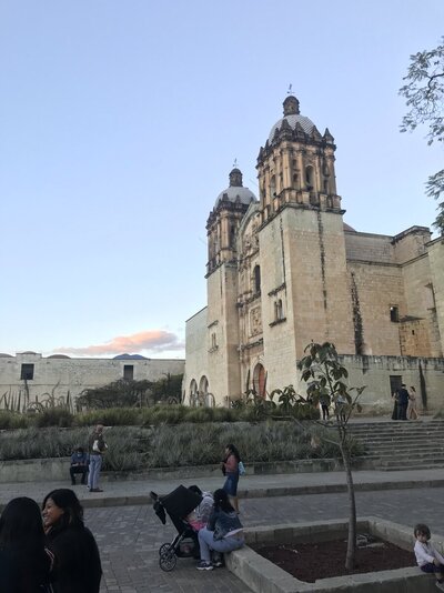
Heading south meant riding toward Oaxaca, on a little-used highway through the Sierra Madre del Sur, to the Southern Highlands and fertile Oaxacan Valley. It’s crossing to the Pacific side near the isthmus, so less than 200 miles. Oaxaca is another wonderful, historic city, populated to a large degree by indigenous Zapotecs. The Saturday markets in Oaxaca were very busy!

SATURDAY SHOPPING

BAKERY STALL IN THE MARKET

OAXACA’S CENTRAL CATHEDRAL
Puebla to Oaxaca had been a southerly trip through the mountains on a narrow, two-lane highway. Taking a day off in Oaxaca, we walked around the neighborhood of our hotel, then to the downtown plaza and market.
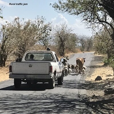
The next day, we decided to head back north to the Gulf, this time along a different rural highway. This leg was on Sunday and there was a bicycle race from Oaxaca to the summit (9,000+ feet). That meant slow groups of bicycles; SAG wagons; very slow, bunched up traffic; many villages; and countless topes! It ended up taking a non-stop five hours to cover about 150 miles, constantly accelerating, passing, braking, slowing, shifting, accelerating, bumping over topes, etc., for what seemed like a thousand times. It was enjoyable but tiring; by evening, every hand-wrist-arm “-itis” made itself felt.
After a night on the Gulf Coast at Coatzacoalcos, we awoke to a cloudy, rainy day, so after breakfast once again set sail south for the Pacific along ANOTHER two-lane mountain road, which took us to the port city of Selina Cruz. Not particularly pretty, cool and extremely windy, so the next morning we decided to head NW, across the mountains via another road to Tehuacan. This one took us through a region that’s rife with roadside agave fields and family-run mezcal distilleries. It looks like the supply chain for mezcal is pretty short - harvest agave hearts from nearby farms, then crush, ferment, distill, and bottle.

AGAVE HEARTS

End Product
In addition to several types of agave for mezcal, the region is covered with cactus of many varieties that we don’t usually see in the SW USA. We decided to continue NW, so again skirted Mexico City, stopping when necessary at their national coffee chain:

Highway Coffee Shop
On what evolved into our homeward leg, we targeted another historic, beautiful city, San Miguel de Allende. Been there before, so it was easy to hit our usual hotel on the edge of the old city center, have dinner at a great Italian restaurant, then stroll around the city. And as usual, when you arrive in town, there’s a very simple way to get to this particular hotel from the main highway. However, there’s also Garmin’s scenic route through the old barrios, down steep hills, up alleys, on cobblestones, etc. Safe to say we’ve used both methods, simple and not-so-simple.

San Miguel Cathedral & Main Plaza
Instead of continuing north up the central valley, we decided to head NNE from San Miguel and cross back into Texas a day later. Our border stop of choice was the village of Nueva Ciudad Guererro, which is right next to Falcon Dam. No one else was crossing there the morning we arrived. Easy to take care of the Mexico exit and USA entrance on opposite ends of the road across the dam. The young lady CBP agent on the US side couldn’t have been more pleasant and businesslike. After the crossing and lunch in nearby Zapata, TX, we split up and headed for home.
My final obstacle was spending a couple of hours crossing San Antonio on a busy, traffic-clogged, stop and go, Friday afternoon. No filtering allowed. I had vowed never to take this route again, but it seems like I forgot…
This trip was normal in every way: Pleasant people, good weather, nice riding, beautiful sights, good food, and no problemlas. Mexico Otra Vez can be summed up very simply: Two riders went to Mexico. Two returned.
No doubt there’s another trip South of the Border in the near future. Until then, adios.
The plan was simple: Ride west. Hit Mexico. Turn left and keep going. See countryside, towns, and cities that we hadn’t seen before (as well as some we had). No trucks or trailers were used to haul the bikes to the border; no pre-determined must-sees; no schedule; no BS like “I’m in, but I have to be home by ____”. With fresh tires and maintenance, along with credit and debit cards, there were no constraints. In the end, a short trip for a little exploring turned into 4,000+ miles. No one called to say, “get your #ss home”. No important emails or voicemails pinged me. No urgent bills hit my inbox. Just riding…seeing the sights…and eating…and riding…and thinking. After all that thinking, it became obvious that margaritas are the answer. As for the question - ¿quién sabe?
Each evening, I’d push the button on the SPOT satellite messenger to automatically say “here I am” to family; I might even call home occasionally to hear about the cold weather.
There are a few things about riding a motorcycle in Mexico that are worth explaining. First of all, motorcycles and motorcyclists are not persona non grata, nor frowned upon, nor looked down upon, nor stepped on, lied to, cheated on, and treated like dirt in Mexico (unlike some places I know). The population in general, and other drivers, in particular, often tacitly acknowledge motorcyclists, sometimes treating us as though “we’re special”, and giving us the benefit of the doubt when we’re riding slow, or fast, or looking for our desired direction, or stopping, or “illegally” parking the bikes, or passing a long line of stopped or slow vehicles, or going the wrong way on one-way streets (which we often do), or just exploring the boonies.
If you want to slowly lane split or “filter” to the front of a long traffic jam at a police/military checkpoint or toll booth or construction blockage, no problem - you just ride between the waiting lines of cars/trucks as long as you can without getting squeezed out by 18- or 26- or 32-wheelers (many semis have double trailers) moving closer together as the lanes narrow. My panniers aren’t any wider than my handlebars, are they??? Or you cross in front of another vehicle and work your way to the right edge of the road, then use the shoulder when there’s room. If the roadside ditch isn’t too deep or rough or wet or likely to have hidden obstacles, you may even use it if you’re on a GS. You may also pass a whole line of cars, trucks, and buses slowing and stopping (their normal practice) at the killer speed bumps (“topes”) that protect every town, village, and city street. You just pass the vehicles on the left with the space oncoming drivers give you, or on the right, using the shoulder. A motorcycle generally bounces over a tope with no problem, while a car or truck or bus could be negatively and severely impacted (hence, their stopping). But abrupt topes sometimes surprise even a cautious motorcyclist and give you a very serious, handlebar-wrenching jolt. Wake up call!
TOPE
Overall, drivers in Mexico are very predictable and not out to push you off the road, as you’re apparently not insulting anyone’s manhood by getting past obstacles or ahead of other cars, buses, and trucks (did I mention that’s not like drivers north of the border?).
Navigation can be tricky South of the Border, so you need to muster every resource: A detailed paper map, Garmin GPS, and Google Maps on your phone. Don’t try to go cheap on phone service - spring for an international plan before leaving home. It’ll save your bacon. The compass and common sense can also come in handy. All roads are not necessarily shown on the map, or not necessarily in the position shown on the map, and roads you see may not exist in the GPS data base. On top of that, the GPS may route you in ways you might wish to avoid. For example, at night, over a mountain, on rough dirt roads, with dead ends, through unknown neighborhoods, without any streetlights...we turned around...just to get to the other side of the city. But there is usually a slightly longer, lighted, paved route also. You kinda want to try to make informed choices.
One of the most enjoyable and arguably little known secrets about South of the Border would be “Mexican minutes”. If you’ve ever ridden down toward Central America, you will have experienced them first-hand. However, many adventurers probably haven’t ridden farther south than, say, Beeville or Corpus Christi. If you did, as you get farther and farther south, several factors are at work:
- The tilt of the earth’s axis
- The speed of the earth’s rotation. Riding south, you’re nearing the equator, and since the earth isn’t perfectly round there, it has to slow down;
- The Gulf stream; and,
- The Tradewinds, which sailors know about, and motorcyclists should.
When you’re down there, you quickly adjust and learn to really appreciate the lingering Mexican minutes. Brooks & Dunn captured the essence of this phenomenon in song:
“We're two days south of the border
feeling too good to care why
These Mexican minutes get longer and longer
as the days go by.”
feeling too good to care why
These Mexican minutes get longer and longer
as the days go by.”
I began the trip by riding west, to Alpine, on a Sunday. If you’ve ever been in Alpine on Sunday evening and are hungry, don’t worry – there’s a gas station for chips and candy. Nothing else. Plus, it rained in Alpine that evening, as I was walking to “dinner”. For goodness’ sake - this is West Texas! Obviously, climate change persists. The next morning, I rode in sunshine to Presidio for the border crossing to Ojinaga, across the Rio Grande. Pretty easy to cross there, no crowds or other vehicles at all on Monday morning. But a US Border Patrol officer who was backtracking across the bridge stopped and lectured me, a taxpayer, law abiding senior citizen, etc., at practically the middle of the Rio Grande bridge, right about where their jurisdiction ends, for riding onto the bridge without stopping at the apparently imaginary exit checkpoint on the US side. First time in my life I’ve ever been told I had to stop at a non-existent exit border checkpoint and talk to a non-existent agent before leaving the country. There was no stop sign or flashing lights or waiting agent or guardhouse or dog or anything telling me to stop, just an orange plastic barrel on the road, which I rode past. I kindly listened to his rude tone of voice for just a moment, then flipped my dark visor closed and rode on to the Mexican side, where they’re nicer. There it was very easy to get the motorcycle permit (I already had my tourist permit from last fall’s trip to Baja). Next, the most important and some might say riskiest stops in town: An ATM for pesos and a nice restaurant for a breakfast of huevos rancheros. Whew – no problema! After that, I could just appreciate the sunny day and riding the 180 miles or so to Chihuahua City.
The steep climb into the mountains west of Ojinaga is a nice change of pace, and from the top you look down upon a beautiful, very narrow Santa Elena-esque canyon. However, there are a bunch of tight switchbacks, i.e., “curvas peligrosas”, as well as gusty winds. Numerous colorful and elaborate memorials dot the roadside, attesting that some didn’t successfully negotiate the “dangerous curves” (probably on a too-fast downhill run).
ROADSIDE MEMORIAL
My riding partner and I weren’t long on the road south from Chihuahua when we had a near miss. He disappeared from my rearview mirror. That in itself may not be a big deal, as it can happen anytime a rider needs a rest stop. But I rode on for about fifteen minutes, all the while slowing slightly, then eventually stopping. After waiting and watching another ten or fifteen minutes, I called him (like I said, you don’t travel without international phone service). Not a great phone connection, but I did hear, “my bike won’t run”. Aghast, I turned around, headed back, and started thinking about what we'd have to do and what might be wrong. Battery? Fuel delivery? Spark?
When I finally got to him stranded beside the road about twenty miles back, we identified a slightly different problem: His ignition wouldn’t come on. Probably just a dead key fob battery. But neither of us had a spare battery, mine being safely stashed at home in my toolbox drawer. I took my fob apart and gave him my battery, so he could turn his ignition on and start his bike. I then located my little plastic BMW “emergency key” (a transponder of sorts) in one of my jacket’s many zippered pockets. Finding the key, and holding it just at the right under-fender spot, while trying not to burn my arm on the exhaust, I turned on the ignition and thumbed the starter button. Worked as advertised. Both bikes were then running, so we proceeded to Torreon-Gomez Palacio, a nice Best Western motel, and a good dinner.
We got up early the next morning to go look for key fob batteries. Walmart, just a few miles away, was our original destination, but enroute we pulled in at a Mexican superstore chain, went in, and came out with four #2032 batteries! I [again] wrestled with my fob to get it apart, put a new battery in, and we were both back to fully functional status (and even holding spare batteries)!
The key fob battery-changing process highlighted the owner’s manual lack of a tool list for changing the key fob battery: 1) Pocket knife; 2) Small flat-blade screwdriver; 3) Medium flat-blade screwdriver; 4) Pliers (preferably vice grips, or a third hand); 5) Hammer; 6) Antiseptic ointment; 7) Band-aids.
We were hungry and needed breakfast and coffee, in a strange city, already checked out of our motel, and too early for most local cafes to be open. We headed toward the highway, all the while lamenting our predicament. But then, like a tropical island emerging from the mist, Starbucks appeared ahead. Espresso, coffee, croissants – crisis averted!
An evening stop in the beautiful colonial city of Guanajuato provided a new, but recurring, challenge. We usually make an afternoon online hotel reservation once we know where we'll be that evening. We can then navigate directly to the hotel. In this case, the Garmin nav somehow helped us find our hotel, despite the narrow, hilly, often-unmarked, maze-like city streets. Checking in, we discovered one detail we had missed online: “Oh no, señor, no tenemos estacionamiento...we do not have parking. But you can ride to our other property, where there is free parking, then take a taxi back here.” OK, we unloaded, then commenced to do just that. But it’s now dark and Garmin has a new address to find, which for some reason just got a lot more difficult. We were routed, turn by turn, through the tunnels under the city. Many times. We stopped at a couple of the city-owned parking lots along the way, only to be told: “Motos are not allowed to park here”. So, we rode through the tunnels a few more times, finally out of the city, up and over the mountain. The hotel was not where Garmin thought it was. We then put the address in Google maps, re-navigated, and found it. In the end, it was much nearer to our hotel than Garmin thought. A quick taxi ride back to our hotel, and we could clean up and walk to dinner. Getting out of Guanajuato the next morning was no problem at all…in daylight.
After riding through the industrial heartland of the north-central part of the country, then the beautiful mountainous areas around Guanajuato and San Miguel, we continued south and skirted Mexico City on the east side. One of the great sights just south of Mexico City is the still-active volcano of legend, Popocatepetl, with its dramatic cone-like shape. “Popo” dwarfs the surrounding countryside, rising to an elevation of almost 18,000 feet. No smoke, steam, or eruption today!
POPOCATEPETL
We continued SE toward Puebla – where that evening we enjoyed another snipe hunt looking for our hotel, using both Garmin and Google, along with a policeman’s directions. The small boutique hotel turned out to be very much worth the trouble, and more or less in plain sight, but sometimes you just can’t see the forest for the trees, depending upon your preconceptions.
The ride to Puebla featured a textbook traffic jam on the autopista – construction, lane closure, and miles of stopped vehicles, largely trucks, waiting to merge into one lane. As I mentioned earlier, you “filter” toward the front of the line using any and every avenue open to a motorbike. No one complains. At times we were right behind (or occasionally ahead of) the police and army vehicles trying to make their way to the front. I confirmed that my panniers are just about the same width as my handlebars…
From Puebla, we decided to explore the foothills of Popo, via dirt roads that we could identify on the paper map. Turns out all of them weren’t actually there, or they intersected with many more dirt roads that were not shown, or they just led us in circles, or all of the above. Once again, we stopped, asked, and received pretty good directions, in Spanish. I didn’t understand all of it, but there were several key words and some hand-waving, which I did understand. Thus, we could get back to the highway and continue south.
TRAFFIC JAM
LOST FOR A REASON
Heading south meant riding toward Oaxaca, on a little-used highway through the Sierra Madre del Sur, to the Southern Highlands and fertile Oaxacan Valley. It’s crossing to the Pacific side near the isthmus, so less than 200 miles. Oaxaca is another wonderful, historic city, populated to a large degree by indigenous Zapotecs. The Saturday markets in Oaxaca were very busy!
SATURDAY SHOPPING
BAKERY STALL IN THE MARKET
OAXACA’S CENTRAL CATHEDRAL
Puebla to Oaxaca had been a southerly trip through the mountains on a narrow, two-lane highway. Taking a day off in Oaxaca, we walked around the neighborhood of our hotel, then to the downtown plaza and market.
The next day, we decided to head back north to the Gulf, this time along a different rural highway. This leg was on Sunday and there was a bicycle race from Oaxaca to the summit (9,000+ feet). That meant slow groups of bicycles; SAG wagons; very slow, bunched up traffic; many villages; and countless topes! It ended up taking a non-stop five hours to cover about 150 miles, constantly accelerating, passing, braking, slowing, shifting, accelerating, bumping over topes, etc., for what seemed like a thousand times. It was enjoyable but tiring; by evening, every hand-wrist-arm “-itis” made itself felt.
After a night on the Gulf Coast at Coatzacoalcos, we awoke to a cloudy, rainy day, so after breakfast once again set sail south for the Pacific along ANOTHER two-lane mountain road, which took us to the port city of Selina Cruz. Not particularly pretty, cool and extremely windy, so the next morning we decided to head NW, across the mountains via another road to Tehuacan. This one took us through a region that’s rife with roadside agave fields and family-run mezcal distilleries. It looks like the supply chain for mezcal is pretty short - harvest agave hearts from nearby farms, then crush, ferment, distill, and bottle.
AGAVE HEARTS
End Product
In addition to several types of agave for mezcal, the region is covered with cactus of many varieties that we don’t usually see in the SW USA. We decided to continue NW, so again skirted Mexico City, stopping when necessary at their national coffee chain:
Highway Coffee Shop
On what evolved into our homeward leg, we targeted another historic, beautiful city, San Miguel de Allende. Been there before, so it was easy to hit our usual hotel on the edge of the old city center, have dinner at a great Italian restaurant, then stroll around the city. And as usual, when you arrive in town, there’s a very simple way to get to this particular hotel from the main highway. However, there’s also Garmin’s scenic route through the old barrios, down steep hills, up alleys, on cobblestones, etc. Safe to say we’ve used both methods, simple and not-so-simple.
San Miguel Cathedral & Main Plaza
Instead of continuing north up the central valley, we decided to head NNE from San Miguel and cross back into Texas a day later. Our border stop of choice was the village of Nueva Ciudad Guererro, which is right next to Falcon Dam. No one else was crossing there the morning we arrived. Easy to take care of the Mexico exit and USA entrance on opposite ends of the road across the dam. The young lady CBP agent on the US side couldn’t have been more pleasant and businesslike. After the crossing and lunch in nearby Zapata, TX, we split up and headed for home.
My final obstacle was spending a couple of hours crossing San Antonio on a busy, traffic-clogged, stop and go, Friday afternoon. No filtering allowed. I had vowed never to take this route again, but it seems like I forgot…
This trip was normal in every way: Pleasant people, good weather, nice riding, beautiful sights, good food, and no problemlas. Mexico Otra Vez can be summed up very simply: Two riders went to Mexico. Two returned.
No doubt there’s another trip South of the Border in the near future. Until then, adios.