Feel free to hang out and lurk as long as you like. However, we would like to encourage you to
 - Joined
- Jan 1, 2005
- Messages
- 4,465
- Reaction score
- 1,228
- Location
- Buda, TX
- First Name
- Rich
- Last Name
- Gibbens
For the third time I was going to be riding motorcycles in Big Bend. In 2002 during my family’s annual vacation to Big Bend my Uncle Roger, who lives in Terlingua half the year, had his motorcycles there and invited me to ride with him. I eagerly took him up on his offer. I hadn’t been on a motorcycle since about 1983 and had forgotten how much fun they are to ride. After 3 days of some short rides around Big Bend I was hooked and started making plans to buy a motorcycle. In the summer of 2003 I bought a Yamaha FZ1 street bike and have been riding it for 2.5 years now. Earlier this year I bought a KLR 650 so I could add some dual sport riding to my motorcycling adventures.
This year’s plan was for me to trailer both my bikes from Austin to Big Bend and then spend 4 days riding with Uncle Roger and my buddy Jeff. Uncle Roger, who was already at Terlingua, had his two bikes, a BMW R100GS PD and a Kawasaki Super Sherpa, prepped and ready. Jeff, who currently lives in Chicago, was to fly into El Paso, rent a car, and drive down to Terlingua. Since we had a dual sport bike for each of us our initial plan was to spend 3 days riding the unpaved roads of Big Bend and 1 day street riding.
December 23, 2005 - Day 1:
Initially, I was going to trailer out to Big Bend by myself, with my wife and two kids joining me 3 days later. However, my wife changed her mind (women get to do that, you know) and decided we would all go out together on Dec. 23rd. Additionally, Mike, a friend of my oldest son, was going with us. So at O dark thirty (Army terminology for really, really early in the morning) the five of us departed Austin for an extra long vacation in Big Bend. I decided to run I-35 south to San Antonio and then take Hwy 90 from San Antonio all the way to Alpine, TX. Even though this route was a little longer than running I-10 west I chose it so we could show Mike the scenic bridge over the Pecos River and could also stop by Judge Roy Bean’s place.
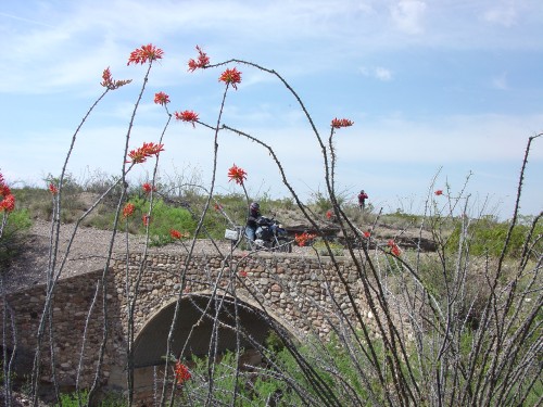
This is the Pecos River Bridge. Completed in April 1959 it is the highest highway bridge in Texas, at a height of 273 feet. The bridge is 1310 feet in length.

As you can see in the above picture, there is some construction currently being done on the bridge (behind the curtains on the right side of the bridge). This picture is taken from the scenic overlook south of the bridge, looking north. I don’t have a picture of it, but if you look south from this point you can clearly see where the Pecos River flows into the Rio Grande river. There was a lot of water this year too. In previous years there has been much less water than is seen in the above shot.
It was dark when I pulled out of my driveway this morning so I waited to take the obligatory picture of my bikes loaded up and ready for Big Bend. I owe a big thanks to my buddy John Murphy for loaning me this trailer.
FZ1 and KLR at the Pecos River scenic overlook.

Just a bit west of the Pecos River is Judge Roy Bean’s place. Judge Roy Bean, in case you don’t remember, is a colorful, legendary western character known as the “Law West of the Pecos”. In addition to being a judge, he also owned a saloon – the Jersey Lilly – in the small community of Langtry, TX. Legend has it that he named both his saloon and the town of Langtry after the love of his life, British actress Lily Langtry (whom he never met). Roy is reputed to have held court in his saloon and is reputed to have sentenced dozens of men to hang, though historians now say there is no evidence he ever actually had anyone hung. A barely legal prize fight on a sandbar in the middle of the Rio Grande river that Roy promoted in 1898 launched his legend and later newspapers and dime novels added to his legend by publishing accounts of his exploits. Paul Newman played Roy Bean in the off-beat, quirky 1972 movie “The Life and Times of Judge Roy Bean”, further contributing to the legend. Today, the Jersey Lilly saloon is a state historical site and museum hosting about 100,000 visitors per year.
The Jersey Lilly Saloon in Langtry, TX

The law, as laid down by Judge Roy Bean and posted inside the saloon. My wife says she needs this sign hanging in her kitchen.

After hanging with the Judge and enjoying a picnic lunch on the grounds, we continued our journey west. While Hwy 90 may be somewhat slower than running west on interstate 10, at least the scenery is better. My uncle says Hwy 90 has “character”, which I interpret to mean that it’s just more interesting to drive on than a freeway. Either way, it’s a looong way to Big Bend – about 500 miles from my house in Austin to Uncle’s place in Terlingua.
After many hours of driving we finally arrived in Alpine, TX., where we tank up with a week’s worth of groceries. There is no supermarket in the Big Bend area, just some convenience stores, so your best and cheapest bet is to buy your groceries before you get to the park. Alpine has a supermarket (yes, “a” supermarket, as in just 1) that has all the necessities including cold beer and wine so it is our default choice.
Alpine, called "the best kept secret in Texas" and "the heart of Big Bend", was founded in 1882 and is nestled in a valley at the foothills of the Davis Mountains. With a population of about 6000 residents it is the home of Sul Ross University (which is nicknamed Cowboy U). Alpine is a scenic little town and when you get there you know you have only about 80 miles remaining before you reach the northern border of Big Bend NP.
Alpine, TX, looking north from Hwy 188 scenic overlook.

Grab your Texas map and take a look at the Big Bend region. If you don't have a good map, here is a link to one posted by the National Park service to their web site that clearly shows the paved roads in and around this part of Texas: http://www.nps.gov/bibe/BIBEmaps/bibemap2.pdf
One thing that will jump out at you is that first, Big Bend is not on the way to anywhere. If you end up in Big Bend you either meant to go there or you are really, really lost. Second, notice that there are only 2 paved roads that lead into Big Bend National Park - Hwy 385 and Hwy 118 – both running north / south. Hwy 385 enters on the east side of the park while Hwy 118 runs down the west side of the park.
The ghost town of Terlingua is located west of the park so we chose to run Hwy 118 south from Alpine. If you look at the map you might think that if you were coming from east Texas it would be faster to jump on Hwy 385 south at the town of Marathon, TX, drive into the park, and then drive west across the park to Terlingua. However, since the speed limit in the park is 45 mph and the Park Rangers zealously enforce the speed limit it’s actually faster to get to Terlingua via Alpine and Hwy 118.
Finally, after about 10 hours of travel, we reach our day’s destination – the Rogerosa. Do you remember the western TV show “The Ponderosa”? Well, my Uncle Roger owns some acreage in ghost town Terlingua that I have dubbed the Rogerosa and that’s where we stay every year. It’s a manly place and it’s not fancy, but it meets our needs and gives us a great base of operations. Plus it has a great view of the Chisos Mountains.
Here’s the view of the Chisos Mountains from the front yard of the Rogerosa. It’s tough waking up every day to this view. Yawn, just another day in paradise.

Uncle has a pet coyote, Odie, who is in charge of ranch security (just like Hank the cow dog). Odie is locked in the howl.
Odie, first thing in the morning.

Odie, as the sun sets on the day. Chisos Mountains Mule Ears in the background.

Everyone should be so lucky as to have an uncle as good as my Uncle Roger. I’m here to tell you that he is one heckuva guy! Aside from his generally excellent interpersonal skills, he is the reason I’m motorcycling today and have vacationed in Big Bend for the past 8 years. These are 2 things I owe him big thanks for.
When I was a kid of about 12, my family went on vacation one summer to visit my grandparents in Oklahoma. During that vacation Uncle Roger was there and he borrowed a couple of dual sport bikes from a fellow he knew. It was my first motorcycle riding experience. Even better, these bikes were for sale and my Dad decided that we should buy them! Want to thrill a 12 year old boy to no end? Buy a dirt bike and let him ride it all the time. I lived in rural Texas at the time and was able to ride pretty much every day after that. For the next 10 years I rode motorcycles regularly, raced motocross for 3 years, and eventually bought my first street bike at age 21.
However, I sold all my bikes a few months after joining the Army and didn’t ride again for 20 years. Riding with Uncle in 2002 reminded me how much fun motorcycles are and I’ve been back on them for 3 years now. Why the heck did I go so long without a bike? How did I ever forget in the first place just how much fun they were? I can only answer these questions with "it's just one of the mysteries of the universe".
The other thing I have to thank Uncle for is introducing me to Big Bend. He had been going to Big Bend for several years and had been thrilling me with stories of his visits there. In 1998 I had the week between Christmas and New Year off and was just hanging around the house bugging my wife. After one day of this she suggested I should go do something and not just hand out at the house for the next week getting in her way. So, I made a spur of the moment decision that my oldest son, Hammer, and I would go to Big Bend. I called Uncle and explained the situation and asked him for advice as to where to stay and what to see. He replied by jumping in his truck, driving to Austin from Corpus Christi, and going with us as our tour guide. Uncle is retired and one of the advantages of being retired is that you can jump in your truck and take off pretty much whenever you want. Of course, we had a great time. My son, Hammer, had such a great time on that trip that it was all he talked about for the next 6 months, which convinced my wife that she needed to go next time. The rest, as they say, is history, and 2005 was our 8th annual trip to the park.
We are blessed to have this trailer to stay in during our annual trips to Big Bend.

A few hours after we arrived at the Rogerosa, my buddy Jeff finally shows up. He only got stopped for speeding once on his drive down from El Paso, but the highway patrolman had mercy on him and let him off with a warning. Sweet!
So ended day 1 with the troupe all assembled and accounted for. Our motorcycling adventures started in earnest the next day.
December 24, 2005 - Day 2:
The sun finally peeks over the Chisos Mountains about 7:50 A.M. so that’s what time we finally roll out of bed. Hey, we’re on vacation. Today’s plan is to ride River Road in the park. River Road is a 51 mile primitive road that traverses the southern portion of Big Bend National Park. Don’t confuse Big Bend National Park River Road with FM 170 that runs between Study Butte (pronounced Stoody Butte) and Presidio. People generally call FM 170 “River Road” but its official state name is FM 170.
Let the adventure begin. The bikes are packed and ready to go, all we need is gas. Roger is in front on the red & white BMW, Jeff is in the middle, and I’m in the back with the mighty KLR. Look how blue the sky is.

We gassed up at The Study Butte store and then entered Big Bend National Park via Hwy 118. Of course, we stopped for the obligatory photos at the park entrance. Uncle is riding his BMW R100GSPD, a 500 lb dual sport bike which is a surprisingly capable in the rough stuff. I’m on my KLR 650 and Jeff is riding a Kawasaki Super Sherpa. The Sherpa is a 250cc dual sport bike that is light and nimble. Its light weight is an asset in the rough stuff, but the 250cc engine is at a distinct disadvantage on the pavement.
KLR at the entrance to Big Bend National Park.

Uncle and his BMW R100GS PD

If you aren't familiar with the Big Bend area, the National Park service has an on-line map of the park that might help you make sense of my report. It's a big map, plus you can zoom in and out, so I'm just going to provide a link to it rather than posting it in the body of my report. Here is the link: http://www.nps.gov/bibe/BIBEmaps/BIBE_Map1_SR.pdf
After paying the park entry fee, we headed west on Old Maverick Road. This is a 13 mile, graded earth road that goes to Santa Elena Canyon on the far west side of the park. It’s not a tough road, any passenger vehicle can handle it, but it does provide us with a good warm up for River Road.
KLR on Old Maverick Road, headed west, looking east.

At the end of Old Maverick Road we jump on the paved Ross Maxwell Scenic Drive and headed over to the Castolon Store for an ice cream. The Castolon Historic Distric was originally built as an Army post, but has been a frontier trading post since the early 1900s and still retains that spirit today. For some reason, ice cream just seems to taste better when eaten here. Check it out the next time you are there and see if you agree.
While we were at Castolon I picked up a copy of the booklet, “Road Guide to backcountry dirt roads of Big Bend National Park” for $1.95. This handy booklet provides detailed guide info on the 4 backcountry roads in the park. I recommend it to you.

After satiating our ice cream need, a short drive up Ross Maxwell Scenic Drive delivered us to the turn off to River Road. The west end of River Road, aptly named River Road West, is quite rough and requires a high clearance vehicle. Or a dual sport motorcycle, which we just happened to have 3 of. We moved steadily along it, my KLR in 2nd and 3rd gear most of the time.
About 20 minutes into our ride on the River Road we met the first of 3 vehicles we saw on the entire 51 miles of River Road. This first vehicle was a Park Ranger in a high clearance SUV. I’m guessing he was doing a routine check of the road to see if anyone was stranded. We waved as we passed him and continued on our way.
While this is good adventure, I do need to point out that you should be well prepared before tackling a remote road like this. This is truly a sparsely traveled road. We packed sufficient food, water, and tools with us everywhere we went to avoid being stranded for an extended period of time. If you were by yourself and unprepared for a break down you could be in serious trouble.
I didn’t take a lot of pictures along River Road West. About 30 minutes into the ride we stopped briefly at a scenic bluff overlooking the Rio Grande and I snapped the following pics of my KLR saying hello to the river and the mountains of Mexico. It’s beautiful out here. It’s quite too. If you live in the city you are probably so accustomed to background noise that you don’t even notice it. Out here when you turn off your engine you are greeted with immense silence. As my buddy Jeff remarked, “Somebody turned the silence way up”.
KLR overlooking a bend in the Rio Grande

KLR with Mexican mountains in the background

After riding 15 miles along River Road we came upon the remains of the Johnson Ranch. The ruins of the ranch house are possible the largest adobe ruin in the entire park. We parked under some trees and enjoyed a lunch of sandwiches, trail mix, crackers, and water. Sorry, no pictures of the food.
Following lunch we eagerly mounted up to enjoy much more of this wonderful backcountry road. As we slowly worked our way east the road became noticeably easier and smoother, allowing our speed to creep up.
After about 27 miles we reached the intersection of River Road and Black Gap Road. I was able to get some pics of us near this intersection with Dominguez Mountain and Elephant Tusk in the background.
Jeff and the Super Sherpa kicking up some dust

Uncle taking advantage of the stop to get a swig of water

Jeff and the Super Sherpa. I love the mountains in Big Bend.

Two Kawasaki’s earning their pay on the River Road

I forget exactly where this was taken, but you can see the Mule Ears in the background

Jeff and the Mule Ears

At this point we reached a navigational decision – do we run Black Gap Road to Glenn Springs Road or do we continue on River Road East? The first choice along Black Gap Road gives us more unpaved riding but Black Gap Road can be very tough riding at times due to serious erosion. Time was getting late and we were concerned about not being able to finish before the sun went down, so we choose to continue along River Road East. We knew it would be a faster and shorter ride and there would be less chance of delay. One of our rules was to not ride after dark due to the high danger of animal strikes during night riding. With the decision made, we continued along River Road East.
After 32 miles of riding we reached Mariscal Mine. This was a mercury or quicksilver mine that included two dozen structures in the valley and on the hills. You can see the remains of various buildings scattered out across the valley and then a larger collection of buildings on the hill.
Mariscal Mine main processing plant, paymaster’s office, and other mine building remains.

Uncle exploring the Mariscal Mine valley. One ruin is directly behind him and you can see another, remarkably well preserved building on the right.

19 miles after leaving Mariscal Mine we reached pavement again. We had made good time along River Road East so we decided to make a quick run south to Rio Grande Village for some cold refreshment and to fill the Super Sherpa’s gas tank. The little Sherpa is a fine bike but it has a pretty small gas tank, something like 3 gallons of gas. We decided it would be best to fill it up at the Rio Grande village instead of risking running out of fuel during our journey back across the park.
As we headed west back across the park, I took advantage of being the only vehicles on the road to snap some action photos.
Jeff and the Super Sherpa. I think it has a top speed of about 70 mph.

Uncle on his BMW

I think Uncle likes this stuff.

After a long pavement ride, we arrived back at the Rogerosa. It had been an excellent day of riding and exploration and all was well in our world. We busted out a few cold ones, discussed the high points of the day, and started finalizing our plans for the next days riding.
More to follow.
This year’s plan was for me to trailer both my bikes from Austin to Big Bend and then spend 4 days riding with Uncle Roger and my buddy Jeff. Uncle Roger, who was already at Terlingua, had his two bikes, a BMW R100GS PD and a Kawasaki Super Sherpa, prepped and ready. Jeff, who currently lives in Chicago, was to fly into El Paso, rent a car, and drive down to Terlingua. Since we had a dual sport bike for each of us our initial plan was to spend 3 days riding the unpaved roads of Big Bend and 1 day street riding.
December 23, 2005 - Day 1:
Initially, I was going to trailer out to Big Bend by myself, with my wife and two kids joining me 3 days later. However, my wife changed her mind (women get to do that, you know) and decided we would all go out together on Dec. 23rd. Additionally, Mike, a friend of my oldest son, was going with us. So at O dark thirty (Army terminology for really, really early in the morning) the five of us departed Austin for an extra long vacation in Big Bend. I decided to run I-35 south to San Antonio and then take Hwy 90 from San Antonio all the way to Alpine, TX. Even though this route was a little longer than running I-10 west I chose it so we could show Mike the scenic bridge over the Pecos River and could also stop by Judge Roy Bean’s place.
This is the Pecos River Bridge. Completed in April 1959 it is the highest highway bridge in Texas, at a height of 273 feet. The bridge is 1310 feet in length.
As you can see in the above picture, there is some construction currently being done on the bridge (behind the curtains on the right side of the bridge). This picture is taken from the scenic overlook south of the bridge, looking north. I don’t have a picture of it, but if you look south from this point you can clearly see where the Pecos River flows into the Rio Grande river. There was a lot of water this year too. In previous years there has been much less water than is seen in the above shot.
It was dark when I pulled out of my driveway this morning so I waited to take the obligatory picture of my bikes loaded up and ready for Big Bend. I owe a big thanks to my buddy John Murphy for loaning me this trailer.
FZ1 and KLR at the Pecos River scenic overlook.
Just a bit west of the Pecos River is Judge Roy Bean’s place. Judge Roy Bean, in case you don’t remember, is a colorful, legendary western character known as the “Law West of the Pecos”. In addition to being a judge, he also owned a saloon – the Jersey Lilly – in the small community of Langtry, TX. Legend has it that he named both his saloon and the town of Langtry after the love of his life, British actress Lily Langtry (whom he never met). Roy is reputed to have held court in his saloon and is reputed to have sentenced dozens of men to hang, though historians now say there is no evidence he ever actually had anyone hung. A barely legal prize fight on a sandbar in the middle of the Rio Grande river that Roy promoted in 1898 launched his legend and later newspapers and dime novels added to his legend by publishing accounts of his exploits. Paul Newman played Roy Bean in the off-beat, quirky 1972 movie “The Life and Times of Judge Roy Bean”, further contributing to the legend. Today, the Jersey Lilly saloon is a state historical site and museum hosting about 100,000 visitors per year.
The Jersey Lilly Saloon in Langtry, TX
The law, as laid down by Judge Roy Bean and posted inside the saloon. My wife says she needs this sign hanging in her kitchen.
After hanging with the Judge and enjoying a picnic lunch on the grounds, we continued our journey west. While Hwy 90 may be somewhat slower than running west on interstate 10, at least the scenery is better. My uncle says Hwy 90 has “character”, which I interpret to mean that it’s just more interesting to drive on than a freeway. Either way, it’s a looong way to Big Bend – about 500 miles from my house in Austin to Uncle’s place in Terlingua.
After many hours of driving we finally arrived in Alpine, TX., where we tank up with a week’s worth of groceries. There is no supermarket in the Big Bend area, just some convenience stores, so your best and cheapest bet is to buy your groceries before you get to the park. Alpine has a supermarket (yes, “a” supermarket, as in just 1) that has all the necessities including cold beer and wine so it is our default choice.
Alpine, called "the best kept secret in Texas" and "the heart of Big Bend", was founded in 1882 and is nestled in a valley at the foothills of the Davis Mountains. With a population of about 6000 residents it is the home of Sul Ross University (which is nicknamed Cowboy U). Alpine is a scenic little town and when you get there you know you have only about 80 miles remaining before you reach the northern border of Big Bend NP.
Alpine, TX, looking north from Hwy 188 scenic overlook.
Grab your Texas map and take a look at the Big Bend region. If you don't have a good map, here is a link to one posted by the National Park service to their web site that clearly shows the paved roads in and around this part of Texas: http://www.nps.gov/bibe/BIBEmaps/bibemap2.pdf
One thing that will jump out at you is that first, Big Bend is not on the way to anywhere. If you end up in Big Bend you either meant to go there or you are really, really lost. Second, notice that there are only 2 paved roads that lead into Big Bend National Park - Hwy 385 and Hwy 118 – both running north / south. Hwy 385 enters on the east side of the park while Hwy 118 runs down the west side of the park.
The ghost town of Terlingua is located west of the park so we chose to run Hwy 118 south from Alpine. If you look at the map you might think that if you were coming from east Texas it would be faster to jump on Hwy 385 south at the town of Marathon, TX, drive into the park, and then drive west across the park to Terlingua. However, since the speed limit in the park is 45 mph and the Park Rangers zealously enforce the speed limit it’s actually faster to get to Terlingua via Alpine and Hwy 118.
Finally, after about 10 hours of travel, we reach our day’s destination – the Rogerosa. Do you remember the western TV show “The Ponderosa”? Well, my Uncle Roger owns some acreage in ghost town Terlingua that I have dubbed the Rogerosa and that’s where we stay every year. It’s a manly place and it’s not fancy, but it meets our needs and gives us a great base of operations. Plus it has a great view of the Chisos Mountains.
Here’s the view of the Chisos Mountains from the front yard of the Rogerosa. It’s tough waking up every day to this view. Yawn, just another day in paradise.
Uncle has a pet coyote, Odie, who is in charge of ranch security (just like Hank the cow dog). Odie is locked in the howl.
Odie, first thing in the morning.
Odie, as the sun sets on the day. Chisos Mountains Mule Ears in the background.
Everyone should be so lucky as to have an uncle as good as my Uncle Roger. I’m here to tell you that he is one heckuva guy! Aside from his generally excellent interpersonal skills, he is the reason I’m motorcycling today and have vacationed in Big Bend for the past 8 years. These are 2 things I owe him big thanks for.
When I was a kid of about 12, my family went on vacation one summer to visit my grandparents in Oklahoma. During that vacation Uncle Roger was there and he borrowed a couple of dual sport bikes from a fellow he knew. It was my first motorcycle riding experience. Even better, these bikes were for sale and my Dad decided that we should buy them! Want to thrill a 12 year old boy to no end? Buy a dirt bike and let him ride it all the time. I lived in rural Texas at the time and was able to ride pretty much every day after that. For the next 10 years I rode motorcycles regularly, raced motocross for 3 years, and eventually bought my first street bike at age 21.
However, I sold all my bikes a few months after joining the Army and didn’t ride again for 20 years. Riding with Uncle in 2002 reminded me how much fun motorcycles are and I’ve been back on them for 3 years now. Why the heck did I go so long without a bike? How did I ever forget in the first place just how much fun they were? I can only answer these questions with "it's just one of the mysteries of the universe".
The other thing I have to thank Uncle for is introducing me to Big Bend. He had been going to Big Bend for several years and had been thrilling me with stories of his visits there. In 1998 I had the week between Christmas and New Year off and was just hanging around the house bugging my wife. After one day of this she suggested I should go do something and not just hand out at the house for the next week getting in her way. So, I made a spur of the moment decision that my oldest son, Hammer, and I would go to Big Bend. I called Uncle and explained the situation and asked him for advice as to where to stay and what to see. He replied by jumping in his truck, driving to Austin from Corpus Christi, and going with us as our tour guide. Uncle is retired and one of the advantages of being retired is that you can jump in your truck and take off pretty much whenever you want. Of course, we had a great time. My son, Hammer, had such a great time on that trip that it was all he talked about for the next 6 months, which convinced my wife that she needed to go next time. The rest, as they say, is history, and 2005 was our 8th annual trip to the park.
We are blessed to have this trailer to stay in during our annual trips to Big Bend.
A few hours after we arrived at the Rogerosa, my buddy Jeff finally shows up. He only got stopped for speeding once on his drive down from El Paso, but the highway patrolman had mercy on him and let him off with a warning. Sweet!
So ended day 1 with the troupe all assembled and accounted for. Our motorcycling adventures started in earnest the next day.
December 24, 2005 - Day 2:
The sun finally peeks over the Chisos Mountains about 7:50 A.M. so that’s what time we finally roll out of bed. Hey, we’re on vacation. Today’s plan is to ride River Road in the park. River Road is a 51 mile primitive road that traverses the southern portion of Big Bend National Park. Don’t confuse Big Bend National Park River Road with FM 170 that runs between Study Butte (pronounced Stoody Butte) and Presidio. People generally call FM 170 “River Road” but its official state name is FM 170.
Let the adventure begin. The bikes are packed and ready to go, all we need is gas. Roger is in front on the red & white BMW, Jeff is in the middle, and I’m in the back with the mighty KLR. Look how blue the sky is.
We gassed up at The Study Butte store and then entered Big Bend National Park via Hwy 118. Of course, we stopped for the obligatory photos at the park entrance. Uncle is riding his BMW R100GSPD, a 500 lb dual sport bike which is a surprisingly capable in the rough stuff. I’m on my KLR 650 and Jeff is riding a Kawasaki Super Sherpa. The Sherpa is a 250cc dual sport bike that is light and nimble. Its light weight is an asset in the rough stuff, but the 250cc engine is at a distinct disadvantage on the pavement.
KLR at the entrance to Big Bend National Park.
Uncle and his BMW R100GS PD
If you aren't familiar with the Big Bend area, the National Park service has an on-line map of the park that might help you make sense of my report. It's a big map, plus you can zoom in and out, so I'm just going to provide a link to it rather than posting it in the body of my report. Here is the link: http://www.nps.gov/bibe/BIBEmaps/BIBE_Map1_SR.pdf
After paying the park entry fee, we headed west on Old Maverick Road. This is a 13 mile, graded earth road that goes to Santa Elena Canyon on the far west side of the park. It’s not a tough road, any passenger vehicle can handle it, but it does provide us with a good warm up for River Road.
KLR on Old Maverick Road, headed west, looking east.
At the end of Old Maverick Road we jump on the paved Ross Maxwell Scenic Drive and headed over to the Castolon Store for an ice cream. The Castolon Historic Distric was originally built as an Army post, but has been a frontier trading post since the early 1900s and still retains that spirit today. For some reason, ice cream just seems to taste better when eaten here. Check it out the next time you are there and see if you agree.
While we were at Castolon I picked up a copy of the booklet, “Road Guide to backcountry dirt roads of Big Bend National Park” for $1.95. This handy booklet provides detailed guide info on the 4 backcountry roads in the park. I recommend it to you.
After satiating our ice cream need, a short drive up Ross Maxwell Scenic Drive delivered us to the turn off to River Road. The west end of River Road, aptly named River Road West, is quite rough and requires a high clearance vehicle. Or a dual sport motorcycle, which we just happened to have 3 of.
We moved steadily along it, my KLR in 2nd and 3rd gear most of the time.About 20 minutes into our ride on the River Road we met the first of 3 vehicles we saw on the entire 51 miles of River Road. This first vehicle was a Park Ranger in a high clearance SUV. I’m guessing he was doing a routine check of the road to see if anyone was stranded. We waved as we passed him and continued on our way.
While this is good adventure, I do need to point out that you should be well prepared before tackling a remote road like this. This is truly a sparsely traveled road. We packed sufficient food, water, and tools with us everywhere we went to avoid being stranded for an extended period of time. If you were by yourself and unprepared for a break down you could be in serious trouble.
I didn’t take a lot of pictures along River Road West. About 30 minutes into the ride we stopped briefly at a scenic bluff overlooking the Rio Grande and I snapped the following pics of my KLR saying hello to the river and the mountains of Mexico. It’s beautiful out here. It’s quite too. If you live in the city you are probably so accustomed to background noise that you don’t even notice it. Out here when you turn off your engine you are greeted with immense silence. As my buddy Jeff remarked, “Somebody turned the silence way up”.
KLR overlooking a bend in the Rio Grande
KLR with Mexican mountains in the background
After riding 15 miles along River Road we came upon the remains of the Johnson Ranch. The ruins of the ranch house are possible the largest adobe ruin in the entire park. We parked under some trees and enjoyed a lunch of sandwiches, trail mix, crackers, and water. Sorry, no pictures of the food.
Following lunch we eagerly mounted up to enjoy much more of this wonderful backcountry road. As we slowly worked our way east the road became noticeably easier and smoother, allowing our speed to creep up.
After about 27 miles we reached the intersection of River Road and Black Gap Road. I was able to get some pics of us near this intersection with Dominguez Mountain and Elephant Tusk in the background.
Jeff and the Super Sherpa kicking up some dust
Uncle taking advantage of the stop to get a swig of water
Jeff and the Super Sherpa. I love the mountains in Big Bend.
Two Kawasaki’s earning their pay on the River Road
I forget exactly where this was taken, but you can see the Mule Ears in the background
Jeff and the Mule Ears
At this point we reached a navigational decision – do we run Black Gap Road to Glenn Springs Road or do we continue on River Road East? The first choice along Black Gap Road gives us more unpaved riding but Black Gap Road can be very tough riding at times due to serious erosion. Time was getting late and we were concerned about not being able to finish before the sun went down, so we choose to continue along River Road East. We knew it would be a faster and shorter ride and there would be less chance of delay. One of our rules was to not ride after dark due to the high danger of animal strikes during night riding. With the decision made, we continued along River Road East.
After 32 miles of riding we reached Mariscal Mine. This was a mercury or quicksilver mine that included two dozen structures in the valley and on the hills. You can see the remains of various buildings scattered out across the valley and then a larger collection of buildings on the hill.
Mariscal Mine main processing plant, paymaster’s office, and other mine building remains.
Uncle exploring the Mariscal Mine valley. One ruin is directly behind him and you can see another, remarkably well preserved building on the right.
19 miles after leaving Mariscal Mine we reached pavement again. We had made good time along River Road East so we decided to make a quick run south to Rio Grande Village for some cold refreshment and to fill the Super Sherpa’s gas tank. The little Sherpa is a fine bike but it has a pretty small gas tank, something like 3 gallons of gas. We decided it would be best to fill it up at the Rio Grande village instead of risking running out of fuel during our journey back across the park.
As we headed west back across the park, I took advantage of being the only vehicles on the road to snap some action photos.
Jeff and the Super Sherpa. I think it has a top speed of about 70 mph.
Uncle on his BMW
I think Uncle likes this stuff.
After a long pavement ride, we arrived back at the Rogerosa. It had been an excellent day of riding and exploration and all was well in our world. We busted out a few cold ones, discussed the high points of the day, and started finalizing our plans for the next days riding.
More to follow.
Last edited: