• Welcome to the Two Wheeled Texans community! Feel free to hang out and lurk as long as you like. However, we would like to encourage you to register so that you can join the community and use the numerous features on the site. After registering, don't forget to post up an introduction!

HOUSTON: NE Houston - Atascocita/Humble area riders!

That looks like a fun little route. An hour and change of wiggle room is nice, too. How is it calculating the 45 average mph? Just based on speed limits + stops? Oh, and which direction are we running it? Clockwise so we're headed west in the morning, and east in the evening?

Picking a particular day might be tough. If we're looking at ~23 hours, starting at midnight Friday will make it tough to get any sleep beforehand for those working, but starting midnight Saturday will make it tough for those working to get enough sleep afterwards. I could do either.
I calculated the overall times and moving times noted above, but forgot to mention I set it up to run clockwise. Leaving at midnight, we should be seeing light around Lampasas, and continuing west and north to Brownwood. That should keep the sunrise sun out of our eyes.

Even though the wildlife data I looked at seems to show that the hazard isn't actually as high as I originally thought, I figured it would be better to run this area in daylight. Then we'll run east with the sun behind us, and down to Lumberton around sunset.

Timewise, we need to check our time and overall average at every stop and keep on it. With the long stretches between towns, we should be able to keep a good average pace.
 
I always feel like I'm just being critical, but I do have one worry. I believe it's been stated a few times on the ironbutt forums that the reviewers of the ride use spotwalla to support the Dated Business Receipts, but they use booble maps or similar and select the 'shortest route' option to track between fuel stops as the primary means of verifying the distance.

It's an issue I've run into with my ride through San Antonio... Taking I-10 through town is, like, two miles longer than skirting around on 1604, but over multiple stops those sorts of things add up. Guess which way I took :/

The reason I bring it up is because it looks like there's several points where a shorter route exists that we are skirting around. Maybe we could seek pre-approval on the route? I don't think they do it much except for certain rides, and those are more because there are additional requirements like a flag being sent.
The rules are here: https://www.ironbutt.com/themerides/ssseries/index.html

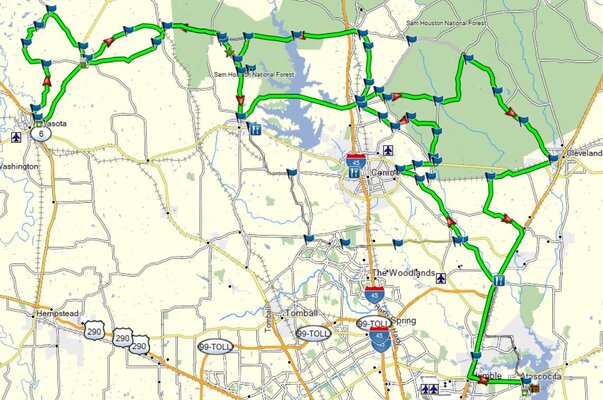
There are a LOT of ways to short circuit this route. However, the key is to document the route well... you do not have to go the most direct route between two points. We will need receipts at the 3 "corners" of the route, since it's kind of a triangle. With the way things lay out, Brownwood isn't a great stop from the fuel range standpoint, but we might decide we have to. I was thinking we could likely do De Leon, San Augustine, and Silsbee for the 3 corners. Should be reliable places to hopefully get a receipt, and close to the furthest extents of the "corners" of the route.

They recommend providing a Google Maps route to outline the route, and I have also used the "tracks" on my GPS to show where we actually went for further verification. The fuel receipts will correspond to those points on the route. In fact, they explicitly state that alternate routes are ok:

"IN ALL CASES, mileage will be verified with either Microsoft Streets and Trips, Google Maps, or in some cases, paper maps or other sources as required.

We recommend you put your route in to Google Maps, it works in most parts of the world and allows you to easily change your route by dragging it on alternate roads. Additionally, it allows you to save your route and send it to us."

This is really simple if you have a painfully simple route. Doesn't work for this one. I'll have to try and re-create it from scratch from within Google Maps. For some reason, you apparently can't get miles out "My Google Maps" and you can't pull a route in from My Google Maps to Google Maps...

If we document it properly and give them more than one way to verify, then we should be fine. I did this once in Alabama, and I didn't submit for the certificate. I had one for a prior ride. My compadre did submit, and he got his certificate. A couple of years later, he did another one... and got another certificate. I printed my tracks map out and marked up the stops for fuel, kept the logs, and it was no issue. I know that a lot of people get complacent and don't want to document their ride to the level they expect, and if IBA can't be presented with the information they need to confirm an alternate route, then they will likely have to assume the shortest route. Those people are probably the ones most likely to complain... on an uncontrolled forum on the internet. :-)
 
Last edited:
LET'S RIDE!

Saturday, 10/16/2021. Meet at 0800, KSU at 0830, Texan Mart, West Lake Houston Pkwy & Aerobic in Atascocita.

The bike is back! Valves adjusted, throttle bodies in sync, and almost ready for a ride. I should be able to find the basecamp route tonight, and I need to go ahead and do a bit of minor maintenance and checking details... but a ride finally looks like a reality for Saturday! High 50s in the morning and low 70s for a high. Sounds like a nice cool ride!

About 290 miles, and a loop up to 1484 near Conroe, back up to 224, and the two little loops just north of Corrigan. Since 59 is no fun, we'll run up to 49 on 1987, then turn around and do 1987 again, and back to fuel at the Exxon in Corrigan, then turn around again to catch the 352 loop, so if Cello can make it... there at two intentional U-turns 😎 
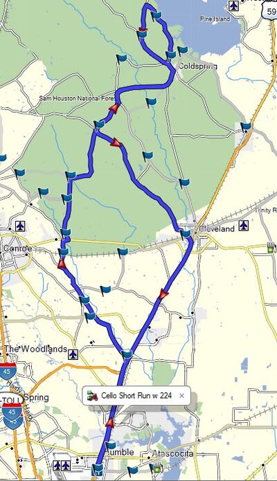
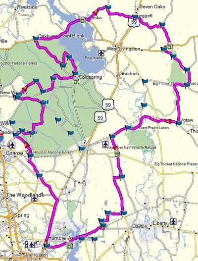
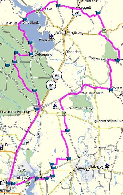
. The Corrigan Exxon is at about 157 miles, so if we need to stop earlier, I'm flexible... Ok... then back down to 942, Votaw, and back via the prison road near Dayton. Should be back to Atascocita around 330.

Here is a link to a map I posted up around the end of March (Post 1628, page 66 of this thread). Highlight, right-click, "go to https..... " to see the map.
 
I need a ride this weekend, and it looks like it has to be Saturday. Sunday looks a bit warmer, but it looks like Saturday is the only time I'm not committed to other tasks. The temps look like mid to high 40s around 9 am, and into the 50s by 10... with afternoon highs in the mid 60s. I'll pull out the cold weather gear and give it a go. I'm thinking a repeat of the 10/16 ride. (see previous Post 1804, just above this one.

Saturday, 11/6, Meet 0830, KSU 0900, Texan Mart, Atascocita.

About 290 miles, and a loop up to 1484 near Conroe, back up to 224, and the two little loops just north of Corrigan. Since 59 is no fun, we'll run up to 49 on 1987, then turn around and do 1987 again, and back to fuel in Corrigan, then turn around again to catch the 352 loop, so if Cello can make it... there at two intentional U-turns 😎 . The Corrigan stop is at about 157 miles, so if we need to stop earlier, I'm flexible... Ok... then back down to 942, Votaw, and back via the prison road near Dayton. Should be back to Atascocita around 330.

Here is a link to a map I posted up around the end of March (Post 1628, page 66 of this thread). Highlight, right-click, "go to https..... " to see the map.
https://www.twtex.com/forums/attachments/capture-jpg.289352/
 
OK... after 2 months of a messed up bike, I think I have all the bad workmanship from the shop corrected. A short test ride, and no codes popping up, but I need a GOOD ride to truly test it out.

Tomorrow, Friday, November 26: KSU 0900 from the Texan Mart in Atascocita.

It will be chilly... maybe near 50, so winter gear is the key. High temps in the mid 60s. About 290 miles, Basecamp says 7 hours or so.

Map attached. I'm thinking the new problems created by the shop are gone now, so I'm not thinking this one will be aborted like the last two. I have literally redone ALL of the work they charged me for, and I have done all the work that they promised and claimed to have done, but didn't. Corrected the grade-schooler issues that I found along the way. The bike was running great on the short test ride yesterday.

UPDATE: It was a bit chilly. high 40s was a bit below the hippo hands and summer gloves. However, 300 miles, a great solo ride, and the bike ran great... no more codes! OK... now for a short ride tomorrow... Sunday, 11/28. See next post.
 

Attachments

  • Capture2.JPG
    Capture2.JPG
    80.3 KB · Views: 108
Last edited:
Sunday, 11/28 Short ride

Needed to set up a short ride to accommodate busy schedules. 135 miles, about 3 hours. Meet at Whataburger at Will Clayton and I-59, 0800. KSU at 0830. There is a Shell Station on the same corner with and interconnecting parking lot. Temps will be around 50 in the morning, around 60 at noon.

1485 and part of 1484 up to Coldspring / 224, back down 1725. Pretty basic route.

UPDATE: It didn't rain... but it was misty with slightly damp roads for most of the route. Temps were a bit better than Friday, but it was wet around Coldspring. The curves on 224 just aren't as much fun on wet pavement, so I turned around and cut it a little short, back to Cleveland on 945. Still a nice ride. The bike was running great! Looking for ideas on a 12/4 ride now... The weather forecast is good for this weekend!
 

Attachments

  • Capture.JPG
    Capture.JPG
    83.8 KB · Views: 113
Last edited:
Ride - Saturday, 12/4!

I'm thinking it's been awhile since I've ridden 3090.... so here's a route!

about 255 miles, about 6 hours. with the good weather forecast, I'm thinking a meet at the Texan Mart on W Lake Houston Pkwy in Atascocita at 7:30, with KSU at 0800. Should be mid 60s in the morning, highs in the mid to high 70s, and low rain chances!

Post up or PM if you're interested!
 

Attachments

  • Capture.JPG
    Capture.JPG
    185.8 KB · Views: 124
Ride - Saturday, 12/4!

I'm thinking it's been awhile since I've ridden 3090.... so here's a route!

about 255 miles, about 6 hours. with the good weather forecast, I'm thinking a meet at the Texan Mart on W Lake Houston Pkwy in Atascocita at 7:30, with KSU at 0800. Should be mid 60s in the morning, highs in the mid to high 70s, and low rain chances!

Post up or PM if you're interested!
Sent you a PM. Coming up from SW Sugarland area. Me and a buddy. We are both on cruisers.
 
LOCATION CHANGE:
Meeting location changed to Whataburger at the N I59 Access Road and Will Clayton, Humble. There is a Shell Station next door if anybody has not posted up and also wants to join in. I should be there between 700 and 730.
 
if it wasn't apparent in the photos, it was a bit foggy when we started. We delayed KSU a bit, hoping the fog would clear and then headed out about 8:30. We made it up through 1484, and the fog was clearing some, but it was still misty wet, so we pulled in to a shell station, and I put on my rain jacket... Obviously, if I'm in my rain jacket it will dry up, right? YEP! 15 minutes later, we were on dry roads! OH... missed the last turn onto Rogers Road... had to do an unscheduled u-turn :shrug:

The pace was a bit more relaxed than normal, but it was a great ride! Got to see a bit of the scenery that I didn't notice before. Great weather, good roads, Had some good lunch at Mallett Brothers Barbeque in Navasota, combined with a few good stories. We'll find the next destination and do it again!

Thanks for riding all the way up from Sugarland. It was great meeting you both, and it was an awesome day!
 
It's been awhile since the last posted ride! Saturday is New Year's Day, so I'm not thinking an early KSU... Texan Mart at 10 am. If need be, I can also meet up at Whatburger on the 59 NB access road at Will Clayton. It's pretty much on the route anyway. For now, for me... Texan Mart.

Meet up at 930, KSU at 1000. about 260 miles, about 6 hours total. 1484, 224, 942, Leggett, Votaw, Dayton Prison. Weather forecast looks like about 30% rain chance for a short time at the beginning of the ride, otherwise dry with a high around 80.

Post up or pm if you're interested!

UPDATE: Meeting at 0930, Whatburger at 59/69 NB access road off the Will Clayton Exit. KSU 1000 +/-

AND... ANOTHER UPDATE!
KSU will be delayed a bit... Meet Time 1000 if anybody is planning on showing that didn't post up / PM. If you arrive at 9:30 and nobody is there... KSU likely 1030 +/-
 

Attachments

  • Capture.JPG
    Capture.JPG
    109.5 KB · Views: 114
Last edited:
Unfortunately, Im out of town until Sunday. Would have loved to go riding with you again. Hopefully can catch up with you soon.
 
EDIT. RIDE POSTPONED: Due to the latest forecasts, this looks like a serious rain day. 80 to 90% chance on the ride to Brenham, and 50% for the first part of the ride around Brenham. Storms and wet roads. I'll have to reschedule soon, when the weather decides to play along.


OK, I think it's time for a Brenham area ride. Sunday, 1/9/2022.

Meet around 7:30 or 8:00 Sunday morning, KS 8:30, Buc-ees in Waller.
The loop is about 300 miles, returning to Buc-ees around 4:30-ish. Lunch stop in Bellville at the Hill close to noon.

Image attached. Counterclockwise on the brown loop, then clockwise on the green loop.

The weather forecasts are all over the place, so I would recommend rain gear. However, the Weatherbug forecast seems to show low rain chances in the morning and dry afternoon for Brenham. I will monitor and provide an alert Friday evening if the weather situation goes bad, but this looks like a good ride window right now!

Pace: mildly spirited sport-touring pace.

Let's Ride!
 

Attachments

  • Capture.JPG
    Capture.JPG
    134.8 KB · Views: 108
Last edited:
Pie Run Ride, Saturday 1/29/22 (See thread: January Pie Run (Southern Style))

This has been a tough weather month! It is looking a bit chilly for Saturday morning, so my 0830 KSU idea may not work... supposed to be in the high 30s. I'll gather up all the winter gear and do a 1015 KSU, Texan Mart, Atascocita, Aerobic and West Lake Houston Pkwy. Still a bit cool, but not as bad. Highs should be near 60.

Should be an hour and change to Moss Hill for pie (~50 miles), and then a run up to to Votaw, Goodrich, 224, and back through Cleveland. about 150 miles from Moss Hill back to Atascocita, around 1600 or 1630.

Not a long ride, but should be some good pie and good company!
 

Attachments

  • Capture.JPG
    Capture.JPG
    91.4 KB · Views: 100
It's been awhile since the last ride, and things are pretty hectic here, but here's what I'm thinking for Sunday, 2/20:
KSU at 10 am, Texan Mart, Atascocita. This is a clockwise run that starts out going up 59/69, so if we need to change it to Whataburger at 59 and Will Clayton, that could work as well.
About 220 miles, 5 hours, including stops. one fuel stop in Onalaska.
224, 942 through Legget, down to Votaw, Dayton Prison, and back to Atascocita.
That's my ride for the weekend. If anybody wants to tag along, post up or PM!
 

Attachments

  • Capture.JPG
    Capture.JPG
    81.6 KB · Views: 92
Had a good ride. Walked out a little late, got on the bike at 10:30. It was in the mid 50s and actually felt pretty warm. Rode in the mesh, but with jeans, 2 LS Tees, and my rain jacket. Perfectly comfortable for the first 75 miles. Stopped in Coldspring for fuel, and the temp was up to 63, but it felt cooler... I think the humidity came up. The rest of the ride, although warmer, felt a bit chilly. Not bad, but chilly.

Overall, a nice solo ride. It looks like they have resurfaced the section of 942 from 59 through Leggett. Nice pavement for a bit. Maybe the rest of the road will get resurfaced this summer. Unfortunately, that may mean construction all summer. Some of the construction on 59 seems to be nearing completion, but the part closest to Cleveland on the south side starting around the flea market is still a bit of a mess. 1725 was good, and I followed really slow cagers through 224. The last several runs up 224 have been unimpeded and great... I guess it was time...

Enjoyed the ride!
 
Sunday, March 6 - Brenham area ride

This ride could be my last of the big ones here... maybe a "last hurrah?" In April, we're looking at packing up and moving to Far, Far, Away (Western KY). I'm still going to try and shoe-horn a shorter local ride or two in before we go, but this is likely the last major... we have a lot to get done before the movers come.

The route includes a lot of the roads that Morgstang showed me long ago, and I've done a little tweaking here and there. The second loop includes a run up to Navasota for a run up 3090. It's a long day for me, but it should be a good ride!

Stats:
Meet at Buc-ees in Waller, 7:30, somewhere around the SW side of the store
KSU: about 8:15
Total Ride: 300 miles, 6 hours + stops, should return to Buc-ees around 4 pm
Fuel Stops in Round Top and Navasota, max leg 125 miles Lunch at Hill Burger in Bellville
I'll be leaving Atascocita at about 6:15 if anybody wants to slab along (will be taking the beltway and 290 to Waller, so ...TOLLS)
We will ride the Brown loop CCW, and then the Green loop CW.
 

Attachments

  • Capture.JPG
    Capture.JPG
    142.6 KB · Views: 100
Last edited:
I’ll meet at Buccee’s. I think meeting up with you first would put me going out of the way a little.
 
Back
Top