• Welcome to the Two Wheeled Texans community! Feel free to hang out and lurk as long as you like. However, we would like to encourage you to register so that you can join the community and use the numerous features on the site. After registering, don't forget to post up an introduction!

Robbers Roost , Brown's Park and Circleville

Joined
Feb 10, 2022
Messages
690
Reaction score
1,245
Location
Lake Travis
Robbers Roost - Part I

The first time I rode through southern Utah was in 2010 on my way home from the west coast. I distinctly remember the ride from Hanksville to Blanding on Highway 95. In a general sense, I was aware I was riding through Butch Cassidy country but had no idea just how true that really was. Each subsequent trip to the region revealed a little more historical information until I became hooked. Robbers Roost Spring is one of three springs in the draw. It is the closest to the canyon and was used primarily to feed livestock. The outlaws did not find the heavy Gypsum taste appealing and would venture further up the draw a ways to Silvertip Spring for sweet water.

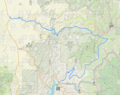
Robbers Roost was the first area directly associated with Butch Cassidy that I researched in earnest. The locals are incredibly sensitive to outsiders coming into the area as evidenced by the "welcome sign" on the map below. They do not mention locations online. At the time, there was no "Robbers Roost Spring" on Google maps to zoom in on. I knew the roost was somewhere between Hanksville and Canyonlands NP but that does not help much. Anyway, if you do go out there, please leave things as you found them.

IMG_1176.jpg


Finding the actual location took months. Ultimately, it came down to comparing some of the known photos of the roost with overhead online maps. I was able to recognize the roost from the circular post corral.

aboveabove.PNG

corralfromabove.PNG

Found it!

IMG_0320.jpg

and finally in person...

What started out as a curiosity quickly became an obsession to find the real details about Butch Cassidy and Matt Warner. A healthy dose of skepticism quickly reveals some obvious truths about these men. Quite understandably, they did everything they could not to be recognized or tracked. Their faces were covered during robberies. The old saying "Never let facts get in the way of a good story" is the guiding principle of most official sources . It really is too bad because the real story of Butch Cassidy is much more interesting.

The only confirmed publicly available first hand account I have ever come across is "Last of the Bandit Riders" written by Matt Warner in the 1930s. Matt, Butch, Tom McCarty and possibly others robbed the San Miguel Bank in Telluride on June 24th, 1889. This is the only robbery that can absolutely be attributed to Butch Cassidy.

Although mostly secondhand, Pearl Baker, who lived on the ranch that encompassed robbers roost, wrote a book based on the first hand accounts. Her family was intimately familiar with all of the outlaws that used the roost for sanctuary. Here is her name, well most of it, on the roost wall.

IMG_0226.jpg

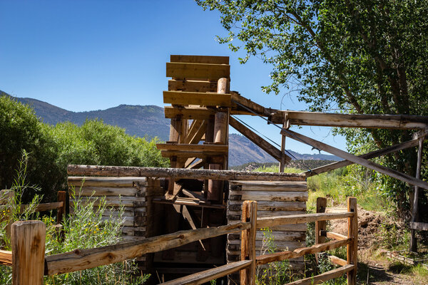
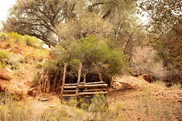
As you can see I missed the P. You can see the "EARL D Biddlecome" which was her married name at the time. In her book titled "The Wild Bunch at Robbers Roost" she details Butch's first ride with rustled horses into Robbers Roost from Kingston Canyon through Fish Lake, Loa, Torrey, Fruita, Hanksville and Angels Point. She writes about Butch turning the horses loose and resting at Robbers Roost Spring where two new Cottonwood trees were taking root. Those trees are still there today.

IMG_0264.jpg

With one of the cottonwoods in the background, the row of posts, which are part of a trough from the early 1900s still remain. The trough in the foreground is used by cattle today.

IMG_0219.jpg

Same scene but from the opposite direction. I'm headed towards the canyon.

IMG_0256.jpg

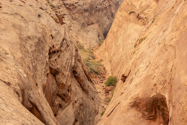
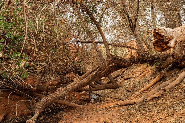
About 50 feet ahead, I encounter the first location used for shelter by the outlaws. The most effective part of the overhang has cracked and fallen onto the ground.

IMG_0230.jpg

About 200 feet further and into the mouth of the canyon

roostabove.PNG

I am standing where the star is located.

IMG_0232.jpg

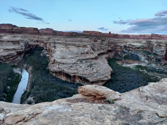
Looking down the canyon. I cannot go any further because there is about a 12 foot drop to the first ledge.

IMG_0250.jpg

and a second ledge...

IMG_0235.jpg

and a third ledge a little further. This canyon intercepts the Dirty Devil river and was just too dangerous and noisy for Sheriffs and their posses to approach. I might have said it was impossible but just 10 minutes later, Kelsey climbed up from the canyon and surprised the **** out of me. Who is Kelsey? I did not know until I got home and looked him up. Apparently, he is quite the legend with the Utah canyon climbers.

Here he is. 71 years old and all he has with him is that little box of essentials on his waist. Amazing...

Kelsey.jpg


IMG_1178.jpg

A final look down the canyon. That is a serious climb and Kelsey did it without ropes.

IMG_1180.jpg

I have turned around and now looking southeast back into the roost.

IMG_0270.jpg

I'm on the opposite side of the tree from the previous image and walking towards the other end of roost draw. Before I go further, a quick look back...

IMG_0364.jpg


To be continued...
 

Attachments

  • IMG_0235.jpg
    IMG_0235.jpg
    550 KB · Views: 167
  • IMG_0217.jpg
    IMG_0217.jpg
    920.5 KB · Views: 126
  • 1651284095471.jpeg
    1651284095471.jpeg
    895.3 KB · Views: 126
Last edited:
IMG_0289.jpg

Slowly following the cows into the main area of the wash. The red sand is tough to walk in. Silver Tip spring which is really just a seep is coming up on the left.

IMG_0295.jpg
The main hideout was located around Silver Tip spring which is up that side canyon.

IMG_0334.jpg
From what I understand, you are looking at the largest natural shelter the outlaws used. As with the overhang at Robbers Roost spring, the most effective part has cracked and fallen onto the ground.

IMG_0338.jpg

IMG_0336.jpg


At the time, I was not familiar with how the roost was used. As a result, this is the closest shot I have of Silver Tip spring. It is probably an overstatement to call it a mini-box canyon but it ends just around the corner to the left. The overhanging ledges provide cover and the spring/seep creates small puddles one can drink from.

Here is a short excerpt from Pearl's book that describes this area well.

Silver Tip was considerably older than the rest of Robbers Roosters, being about forty or thereabouts in 1890. His hair around the temples was just turning gray which is what he got his name from. Silver Tip and ten companions rode into the country in the fall of 1889 or 1890 landing at the mouth of white canyon across the Colorado river from Hite. He eventually crossed the river at Dandy crossing ventured into the Henry mountains. He signed up with Jack Moore for a spring ride into the roost and that is how he became associated with the hide out.

Jack, Silver Tip, Blue John and Indian Ed Newcomb made a run into Wyoming to steal horses. It did not go well for them at all. Jack Moore was killed and they were pursued by Moab Sheriff, Jesse Tyler and his party. The Moab-Times Independent (Grand Valley times then) of March 3, 1889 states:

Sheriff Tyler and posse, Andrew Tangren, J.C. Wilcox, H. Day, William Wilcox and R.W. Westwood returned from a 12 day trip into the San Rafael country after horses stolen from Andrew Tangren two weeks ago. They did not get the horses they were after but found two that were taken from Joseph Taylor and Thomas Larsen last summer. The party relate an exciting incident of the trip. In trailing up the horses from here, they lost the trail on the other side of the Green River. Believing they could get assistance in learning the trails from people further west, they went to Hanksville, but failed to secure any assistance there, and went on as far as the Henry Mountains. On their return last Monday, at a point about 50 miles south of the Green River Station they saw a fresh trail leading into San Rafael country and followed it up. When indications were that they were close in on the party, they waited until night and located them by their campfire, but they were in a side canyon under shelving rocks that was impossible to approach without discovery. They kept watch until morning when one of the group, a half Indian came out into the open and was ordered to throw up his hands, but instead commenced shooting and the sheriff party opened fire on him. He dropped and was last seen crawling behind the rocks. The others came out into the open and one fired a shot into the air and yelled to the Sheriff's party to drift, but was answered by a volley. A battle then commenced and lasted for nearly two hours, a hundred or more shots were fired on both sides, as far as known without damage. Fire from behind the rocks finally stopped, and the Sheriff's party, being mostly out of ammunition, withdrew.

That was one side of the story, the account from the outlaws is much more interesting and can be found in the book.

IMG_0303.jpg

Looking towards one of the possible locations of Sheriff Jessie Tyler's party.

IMG_0344.jpg
The rock formations are out of this world.
IMG_0298.jpg

IMG_0309.jpg
Turning back to the main draw, Rabbit Brush spring is located where the small trees are in this rectangular corral.

IMG_0316.jpg

The circular corral up close.

IMG_0320.jpg

The circular corral posts are the originals from around 1900.

IMG_0350.jpg

A little further down the wash is what as known as the roost house. Built sometime after Butch Cassidy, Sundance and Etta Place left for South America.

IMG_0353.jpg

The cabin apparently burned down after one of the outlaws discovered it full of rats and attempted to get them out.

IMG_0372.jpg

Finally, a look down into the roost from above. The remoteness of the roost cannot be overstated. About 40 miles of unpaved roads must be traversed to get there. It's easy to get lost.

Pearl Baker's account of Butch Cassidy at Robbers Roost is the only documented "possible" evidence of him being there. How many times he actually visited is unknown. The stories of numerous other outlaws, many from Texas, are just as interesting.

Here are a few interesting videos by others...

The angel trail was an entrance into Robbers Roost from the west. This video shows just how dangerous it was:

A pretty cool drone video

A nice walk through:

Video of locals including AC Ekker at the roost

Next stop on the Outlaw Trail - Brown's Park, Colorado
 
Last edited:
Brown's Park, called Brown's Hole in the 19th century was the middle stop on the outlaw trail. Strategically located at the state borders of Colorado, Utah and Wyoming, it was home to ranching families such as Ann and Josie Bassett who were close with Butch and his good friend Elzy Lay.

If Colorado authorities were after them, they would step into Utah. If Utah authorities were after them, they would step into Colorado and so on. This kind of arrangement went on for years until Tom Horn was paid to clean the valley out. After he was done, Joe Lefors conspired to frame him for Wyoming cattle barons Butch knew all too well. They hung Tom to cover up the link to them.

IMG_8855.jpg

Riding west from Steamboat Springs, I took a right in Maybell and headed towards the valley. Even today, this is still the most remote area of Colorado. It makes for a very nice 60 mile ride to the Green River.

IMG_8848.jpg

About 45 miles down the road, Brown's Park comes into view. Diamond mountain is in the middle horizon.

IMG_8864.jpg

On the other side of Diamond mountain across the Utah state line. Brown's Park and the Green River are visible in the distance.

IMG_8933.jpg

Diamond mountain - Matt Warner and Butch Cassidy are said to have had a cabin somewhere on the mountain and could easily spot the law entering the valley from either direction.

The John Jarvie Historical Ranch

johnjarvie.jpg

John Jarvie was a merchant who sold supplies to the folks in Brown's Hole. He was a friend of Butch's and helped him numerous times.

IMG_8915.jpg

John Jarvie Historical Ranch on the Green River.

IMG_8873.jpg


IMG_8877.jpg

The Jarvie trading post.

IMG_8879.jpg

The Green River. It looks like you could wade across but apparently not.

IMG_8913.jpg

IMG_8914.jpg


speck.jpg

Speck Williams ran the ferry at the Jarvie trading post

IMG_0095.jpg

The remains of his ferry landing.

IMG_8892.jpg

The original location of the Jarvie water wheel with replica.

IMG_8890.jpg

When John originally moved to this location, they spent their first year in this dugout. Years later, it is said Butch Cassidy hid and slept.
IMG_8889.jpg


IMG_8923.jpg


IMG_8924.jpg
IMG_8900.jpg
 

Attachments

  • IMG_8893.jpg
    IMG_8893.jpg
    651.2 KB · Views: 102
In the Summer of 2020, I was making my way towards Salt Lake City. I had previously passed by Dinosaur National monument several times, but decided this time to head in to see Josie Bassett's cabin. At one time or another, Josie and Butch were involved with each other.

The cabin and area surrounding it were a complete surprise. It turned out to be one of the most peaceful places I have ever visited. The following is a description of her I found online.

"Josie Bassett stands out as one of the most colorful characters in Uintah County’s colorful past. She was a unique blend: a sweet, generous, lovable white-haired lady who occasionally rustled cattle, poached deer, and brewed bootleg whiskey to survive and help family and friends. For 50 years she lived alone in a cabin without plumbing, telephone, or electricity deep within what is now Dinosaur National Monument. Content among her flowers, gardens, orchards, cattle herds, and assorted domestic animals, she became a fascinating minor character in the pageant of the West.

The Bassetts, an unconventional family, came to Brown’s Park in the 1870s. From her mother’s example and from growing up on a cattle ranch, Josie learned the skills of riding, roping, shooting, cattle raising, and strong-willed independence. From her gentle father, she learned to be mannerly and generous. The companions of her youth were cowboys and the outlaws who frequented Brown’s Hole. Later, Josie was sent to St. Mary’s of the Wasatch in Salt Lake City to be educated.

A succession of five husbands made Josie notorious. She divorced four—a scandalous process in those days—and was widowed once. That husband died, most likely of acute alcoholism, although some claimed Josie had poisoned him. She was never free from rumors. When lands near Vernal were opened up for homesteading in 1913, Josie decided to make a new life for herself. She was nearly 40 when she left Brown’s Park and found the land she wanted on Cub Creek, 10 miles and two canyons north of Jensen. After a few years she ran her current husband off with a frying pan. However, she had at last found true love in her homestead and made a life-time commitment to it."

IMG_9477.jpg
Dinosaur National Monument - Jensen, Utah
IMG_9480.jpg


IMG_9464.jpg

My long distance horse in front of Josie's cabin.

IMG_0424.jpg

IMG_0416.jpg

IMG_9447.jpg

IMG_9441.jpg

IMG_9442.jpg

IMG_9462.jpg

Hog Nose Canyon
 
Finally, Circleville, Utah. The location of Butch Cassidy's last childhood home. It took me years to skip Utah Highway 12 and swing around by Circleville. I got the chance last year and really enjoyed the experience.

IMG_1076.jpg
My horse tied up in front of the Parker ranch.

IMG_1078.jpg

The row of poplar trees were planted by Butch (Bob Parker) and his Mother. Like the Cottonwood trees in Robbers Roost, they are struggling, but thankfully still there for all to see.

IMG_1080.jpg

1880 Census roll listing of the Parker Family.
IMG_1081.jpg


IMG_1083.jpg

The Pinkertons act like Butch removed his bandana and introduced himself to everyone in the bank. There is speculation other members of the gang, including Sundance were the actual perpertrators of the Winnemucca bank robbery but no one really knows. I am surprised they do not list the Castle Gate robbery which had nothing to do with Butch either. That was Joe Walker and Johnny Herring who actually looked like Butch.

IMG_1084.jpg

A closer look at the Parker cabin.
IMG_1111.jpg

IMG_1107.jpg

The field Butch and his siblings worked. I know I said the area where Josie Basset's cabin was one of the most peaceful places. Well, so is the Parker ranch. No phone service. Just the sound of wind and the occasional passing vehicle.

Beyond a few documented pieces of evidence, the honest truth about the history of Butch Cassidy is largely unknown. As I mentioned from the start, these guys (and girls - for example, Laura Bullion from Knickerbocker, Texas) did not want to be recognized or tracked. Unfortunately, that does not stop the history channel or true west magazine from making things up.

I still have a few places to visit:

Hole in the Wall near Kaycee, Wyoming - Map - Hole in the Wall
Museum of the Old West - Cody, Wyoming - Butch's cabin from Hole in the Wall has been relocated here.
Poison Spring Canyon, Utah - Cassidy Camp - There is a Butch Cassidy Signature on a large rock.
Cedar Mountain, Utah - There is another Butch Cassidy signature etched into a rock.

I hope you enjoyed the photos and background info!
 
I occasionally look online for information regarding a few places I have not found yet. In this case, it is a Butch Cassidy signature on a rock in Poison Spring Canyon. Some nice people put this video up that finally shows it.

 
Missed this when you started it . I made the loop across 318 to Dutch John then to 40 and back to Maybell but didn’t venture of the highway any , all of my riding off road was while I was based in Maybell .
 
I just got back from Utah a few hours ago and rode poison springs. I was going to post some pics later and took a video when I rode through the canyon. Had no idea about butch till now. I'll have to watch this whole video later on. Thanks for posting. I really have a reason to go back now!!
 
I just got back from Utah a few hours ago and rode poison springs. I was going to post some pics later and took a video when I rode through the canyon. Had no idea about butch till now. I'll have to watch this whole video later on. Thanks for posting. I really have a reason to go back now!!
Very cool. I would love to see those photos and videos. A couple of us are going up there pretty soon. Did you cross the Dirty Devil? I was looking at the gauge today and is says about 5.24 feet. That seems high but could be snow melt from Fishlake.
 
Very cool. I would love to see those photos and videos. A couple of us are going up there pretty soon. Did you cross the Dirty Devil? I was looking at the gauge today and is says about 5.24 feet. That seems high but could be snow melt from Fishlake.
I didn't make it that far. I went through the canyon then it comes to a big switch back drop down. It wasn't to bad but I was solo on a loaded Tenere so I was worried about it getting tougher than the canyon so I turned around. I went back south on 95 where the road through the canyon is supposed to end up, once you cross the Dirty Devil on 95. I followed it to to where it goes into Canyon land NP but it was getting late in the day and you have to have a permit to camp there so I turned around, again. Ended up camping on the Dirty Devil just north of where it spits into the Colorado. Pic below.

WHEN I go back again I think I'm going to follow it all way through the canyon then down that switch back and keep going because I'm pretty sure once you drop down it's a smooth road the rest of the way. If not I'll just turn around again. It always looks different the other way around anyhow.

I did part of the BDR, knowing it was still snowed under, and a guy in a store a stopped in told me they were concerned about flooding this year due to all the snow melt. I turned around two other times when I came to roads that were flooded or creeks that were moving.
 

Attachments

  • KIMG0723.jpg
    KIMG0723.jpg
    361.5 KB · Views: 70
  • KIMG0724.jpg
    KIMG0724.jpg
    513.3 KB · Views: 60
Last edited:
I didn't make it that far. I went through the canyon then it comes to a big switch back drop down. It wasn't to bad but I was solo on a loaded Tenere so I was worried about it getting tougher than the canyon so I turned around. I went back south on 95 where the road through the canyon is supposed to end up, once you cross the Dirty Devil on 95. I followed it to to where it goes into Canyon land NP but it was getting late in the day and you have to have a permit to camp there so I turned around, again. Ended up camping on the Dirty Devil just north of where it spits into the Colorado. Pic below.

WHEN I go back again I think I'm going to follow it all way through the canyon then down that switch back and keep going because I'm pretty sure once you drop down it's a smooth road the rest of the way. If not I'll just turn around again. It always looks different the other way around anyhow. (isn't that the truth)

I did part of the BDR, knowing it was still snowed under, and a guy in a store a stopped in told me they were concerned about flooding this year due to all the snow melt. I turned around two other times when I came to roads that were flooded or creeks that were moving.

I get it. I rode down that road by myself on a WR250R last year and turned around for the same reason. This time, I hope we are able to ride the entire road all the way back to 95. That area between the confluence of the Colorado and Dirty Devil rivers is amazing. I bet Bears Ears is completely snowed over right now.
 

Attachments

  • Capture22.PNG
    Capture22.PNG
    2.5 MB · Views: 63
I get it. I rode down that road by myself on a WR250R last year and turned around for the same reason. This time, I hope we are able to ride the entire road all the way back to 95. That area between the confluence of the Colorado and Dirty Devil rivers is amazing. I bet Bears Ears is completely snowed over right now.

Thats the track I was planning on following. Even if you cant cross the river and have to turn around and then take 95 to the other end and ride that to the river, and turn around again, like you say its still a great ride. That was kind of my plan once I got to that switch back since I was just riding with no real plan.

Anyhow not to highjack your thread but heres the video. Be aware it's up to 7 min and 20 secs of your life you'll never get back. :-)

 
To get around/across the Dirty Devil and into Robbers Roost, outlaws either had to go north of Hanksville into the San Rafael desert, make the frightful descent at Angel Point (the video further up with the falling horse) or ride south through Poison Canyon. That was a very nice video. Thanks for taking us there. I hope you will post up a ride report. There are a bunch of us that would love to see more.
 
Back
Top