• Welcome to the Two Wheeled Texans community! Feel free to hang out and lurk as long as you like. However, we would like to encourage you to register so that you can join the community and use the numerous features on the site. After registering, don't forget to post up an introduction!

The Copper Canyon - Big Bend Loop

Joined
Jan 1, 2005
Messages
4,465
Reaction score
1,228
Location
Buda, TX
First Name
Rich
Last Name
Gibbens
The Copper Canyon - Big Bend Loop


Prologue

It has been on my mind for about 2 years, sort of like that commercial where the guy has the little car stuck to his forehead. In that commercial, during each subsequent scene the car stuck to the guy’s forehead gets bigger and bigger. That guy had a new car purchase on his mind; I had Copper Canyon on mine.

It wasn’t like I had gone out seeking this. I was minding my own business, completely innocent. All I was doing was surfing the web over at Adventure Rider when I ran across a story called “Cantina Crawl 2004 (Sierra Madre and Copper Canyon)” by Kevlar. It sounded like an interesting story so I clicked on it without a second thought, completely unsuspecting of the long term effect it would have on me. It was a story with lots of pictures of a motorcycle adventure to Copper Canyon and it completely captured my imagination. Once I finished the story I called my wife into the room, pointed out some of the pictures of Copper Canyon to her, and told her I would sure like to go there.

It took 2 years for me to get everything arranged for the trip. I bought a KLR 650, made the necessary modifications to it for long distance travel, and took care of the multitude of other stuff necessary to make the trip (luggage, passport, gear, time off, funds, riding partners, etc.). Finally, I was ready to go.

Originally four of us were going to make the trip. However, one of the guys dropped out due to an arm injury. Another friend of mine was going to replace our lost rider, bringing our number back to four, but in the end my friend wasn’t able make the trip either. So, we were down to three riders just one week prior to the trip. But fate wasn’t finished with us just yet. Mike, the third rider, was having serious knee problems and decided the wisest course of action would be to stay in the U.S. He was concerned that his knee just wouldn’t be up to the amount of unpaved road riding we would be doing in Mexico. Mike and I would trailer our KLRs out to Big Bend together and he would spend a week riding in the Big Bend area while Uncle and I headed off for Copper Canyon.

The die was cast. The basic plan was:

Day 1 – trailer from Austin to Uncle’s place in Terlingua, TX (Big Bend area)
Day 2 – Terlingua, TX to Creel, MX
Day 3 – The road to Batopilas
Day 4 – Back to Creel
Day 5 – Divisidaro & Basaseachi Falls
Day 6 – El Paso
Day 7 – Indian Hot Springs, TX
Day 8 – Terlingua via the Lost Trail
Day 9 – Austin

Day 1 – Austin to Terlingua

Mike showed up at my house around 10 a.m. on the Friday before Thanksgiving. We loaded up my KLR into his trailer with his KLR and headed towards Terlingua as fast as the law would allow.
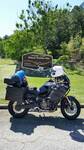
Loaded
IMG_0760.jpg


We made a stop at Whittington’s Jerky in Johnson City to stock up on jerky – regular beef, teriyaki beef, and turkey jerky. That Whittington jerky is just plain ‘ol good.

IMG_0759.jpg


Not much else to tell about the ride out to Terlingua; just 500 miles of slab. The real fun starts tomorrow
 
R1200GSA said:
:popcorn:

Will you be able to share your route(s)?

Yes, I will be sharing the route. I'm trying to combine the story of my trip with enough travel information that others could use this as part of their own ride planning.
 
The Copper Canyon - Big Bend Loop: Day 2

Day 2 – Terlingua to Creel, 386 miles

Uncle roused us out of bed at 6:45 a.m. The sun was not yet peaking over the Chisos Mountains, but the sky was bright enough to let us know that it wouldn’t be long till the sun made its appearance. The air was pleasantly cool and not a cloud was in the sky. It was going to be a glorious day in the desert. Despite my excitement at finally making a run to Copper Canyon, I had managed to sleep well during the night.

The previous evening, Mike and I had arrived after dark and hungry. We decided to go find some supper and wait till morning to unload the bikes. After rolling out of bed the morning of day 2, the first job was getting the bikes unloaded from the trailer and packed for the trip. Even though Mike wasn’t going to Mexico with us, he was riding Hwy 170, aka River Road, over to Presidio with us. For those who haven’t ridden it, Hwy 170 runs 67 miles west from Study Butte to Presidio and it is arguably the best 67 miles of motorcycling road in all of Texas. It is a twisty, scenic, gem of a road.

Mike rides a 2006 lime green KLR. That’s Odie in the background. Odie is locked in the howl.
IMG_0761.jpg


I ride a 1998 KLR. The weather was about 50 degrees and the sun was just now peaking over the Chisos Mountains.
IMG_0762.jpg


Uncle has a 2006 Wee-Strom. He has added Moto-Sport panniers, a bash plate / crash bar combo, and a new set of TKC 80 tires to toughen up the Wee and make it more “unpaved road” worthy. It worked too; the Wee-Strom is a very impressive machine. It had absolutely no problems handling any of the roads we tackled the entire trip. It’s easy to see why the assimilations continue.
IMG_0764.jpg


Uncle’s beloved BMW R100GSPD is in the background, covered up. He bought it new more than 10 years ago and has ridden it more than 100,000 miles. A year ago, pre-Wee Strom, I asked Uncle if he might consider selling the Beamer and upgrading to a new R1200GS. He said he had no intentions of every selling the R100GS because he felt it was the best bike he had ever owned. Yet today the old girl sees little action; the Wee has taken its place. Uncle tells me the Wee is lighter, more nimble, and handles better than the Beamer. He even mentioned maybe selling the Beamer; high praise indeed for the Wee.

After everything was loaded, our next action item was breakfast. The best breakfast in the area is Kathy’s Kosmic Kowgirl Kafe. This place used to be The Hungry Javelina and Kathy used to run it. Today, Kathy owns the place and the name has changed, but everything else is the same. Great food eaten around a cowboy campfire with a big, friendly, local dog nearby to scoop up any food you might drop on the ground. I highly recommend this place to you next time you are in Big Bend. You can’t miss it – it’s distinctively pink, located on the south side of Hwy 170, next to the Chisos Mining Company Motel. One thing though – don’t be in a hurry when you get there. Kathy waits till you order before she cooks your food, so settle down to Terlingua time and enjoy the unique pleasure of a cowboy breakfast. Both Uncle & Mike recommend the Frito Burrito. I think Mike had one every day of this trip that he was in Big Bend.

Here’s Uncle and Mike enjoying a cup of coffee and the fire while breakfast is cooking.
IMG_0766.jpg


Bikes packed and bellies full, it was time to ride. As mentioned earlier, we headed west on Hwy 170 to Presidio and the international border crossing into Ojinaga, MX. We didn’t stop to take any pictures of River Road since we had a long way to go before the end of the day. Once we reached Presidio we topped off our gas tanks and then rode over to the port of entry. It was here that we bid goodbye to Mike for 5 days. Mike was going to spend his time riding the roads in Big Bend while Uncle and I toured Copper Canyon. We would meet up with him in Sierra Blanca on Thanksgiving morning.

Saying goodbye to Mike before crossing into Mexico
IMG_0767.jpg


It had taken about an hour to unload and pack the bikes, an hour to eat breakfast, and a little over an hour to get to Presidio, top off on gas, and reach the port of entry. So, it was 10 a.m. when I started on my border crossing paperwork (Uncle had taken care of this the day before). It took me an hour to get my tourist card, vehicle import sticker, and exchange dollars for pesos. The tourist permit was free because I was going to be in the country less than 7 days. If you are going into Mexico for 7 or less day, the permit is free; 8 or more days and you pay a fee. The vehicle import fee was $329.97 pesos, or about $31 dollars, which was charged to my credit card.

At 11 a.m. all the necessary paperwork was done and we headed west from Ojinaga on Hwy 16. A new toll road has been built, but the older, free road is still available, which is what we opted to ride. Navigation was not particularly difficult and there was sufficient signage to find either the toll road or the free road to the city of Chihuahua.

About 25 miles south from Ojinaga, after a pleasant, somewhat twisty ride through the desert, we climbed the first set of mountains we would cross that day. At the top of this first mountain range outside of Ojinaga is Peguis Canyon – a dramatic and beautiful canyon.

The valley of Peguis Canyon, looking southeast.
IMG_0768.jpg


Large religious symbol at Peguis Canyon. Candles were lit inside the little building. The big painted rock is unique, but we saw lots of those little buildings during our trip.
IMG_0769.jpg


We didn’t take the time to hike down to the view of the canyon. Here’s a shot from the Ojinaga web site at http://ojinaga.com/Peguis/peguis.html
APeguisCanyon.jpg


Also, you don’t need a tourist card or a vehicle permit to visit Peguis Canyon. The military checkpoint is set up west of Peguis Canyon so you can visit the canyon without having to do any paperwork or pay any fees. The next time you are in Big Bend I recommend a side trip to Peguis Canyon.

After leaving the canyon, we continued on to Cuidad de Chihuahua (Chihuahua City). It is about 140 miles from Ojinaga to Chihuahua and is mostly high speed riding. The first 90 miles or so is quite fun, with alternating stretches of desert and mountains. Once we hit Aldama though, the fun riding disappeared for a long time. Of the 386 miles from Terlingua to Creel, the first 150 or so are fun and the last 35 miles into Creel are fun. The middle 200 aren’t great though. The thing that surprised me the most from Aldama all the way to Creel is the high amount of traffic we ran into. At places it was bumper to bumper traffic, even outside the cities. The road repairs west of Chihuahua slowed our pace even more. So, we slogged through the middle 200, knowing better riding awaited us ahead.

Another thing that surprised me was how low the posted speed limits were. Not that anyone actually obeyed them, but it wasn’t uncommon to see a long straight of pavement stretching 20 or more miles across the desert with a speed limit of 80 km/hr (50 mph). Imagine a long straight road across the Nevada desert with a 50 mpw speed limit and you’ve got the right idea. We cruised at 70 mpw, which seemed to be a very safe speed for the given conditions (and we were passed by other vehicles moving quite a bit faster than us). No matter where we rode, the posted speed limits were very slow. We didn’t ride particularly fast anywhere we went since we didn’t want to take unnecessary chances, but we certainly rode faster than the posted speed limit. But, then again, so did everyone else.

Navigation proved to be pretty easy. There was quite a bit of signage and during the entire 380 mile day I had to consult my map only once. Adequate signage proved to be the rule, not the exception, and we were never “navigationally challenged” the entire trip.

West of Chihuahua we stopped in a restaurant for a very late lunch. I had difficulty getting the waitress to understand that I wanted bottled water, until finally figuring out that I needed to ask for agua purificado.

Uncle and the waitress. Lunch was steak for him, enchiladas pollo (chicken) for me. The food was excellent.
IMG_0771.jpg


As we continued our way toward Creel I started to suspect that we might not make it before nightfall. The slow start in the morning, the heavy traffic, and the road construction combined to slow our pace. It was going to be close. At the turn south off Hwy 16, we entered the mountains with only about 30 miles of great riding remaining until Creel. The sun dipped below the hills, but I knew we had about 30 minutes of light before EENT (end evening nautical twilight – or before it was dark). Things were going well and I started to believe we might make it, but it was not to be. Full dark caught us just a few miles outside of town so we slowed our pace and rode the last 5 miles or so to Creel in the dark. Note to self – next year don’t take 2 hours to pack and eat.

A potentially dangerous event occurred in one of the little villages we passed through before reaching Creel. The sun had just dipped below the horizon when I spotted a person standing in the middle of the road. He had his back to me and was just standing there, doing what I don’t know. I honked my horn to alert him that I was coming and he took a step to the side of the road, as if to get out of the road. Then he suddenly changed his mind, stepped back to the middle of the road, and turned to face me, assuming a crouch like he was ready to fight. A scene from the movie First Blood flashed through my mind. Rambo goes wild in the jail after being abused by the sadistic deputy and escapes out into the street. Rambo runs into the street and clotheslines a passing motorcyclist. That’s what the guy in the street in front of me looked like he meant to do to me. It was as if he was going to try and clothesline me as I rode by, or tackle me, or something equally insane. I grabbed the brakes and hugged the left side of the road as I passed the crazed man. He didn’t try anything as I rolled past him, he just watched me, then I saw his attention turn to Uncle. Out of the corner of my eye I spotted a woman and a few other folks on the side of the road, watching the crazy man closely. I figured the guy was drunk and that was his wife and neighbors watching him stumble around out of control. Uncle managed to avoid the guy to, so we skedaddled out of there, not waiting around to see what happened next. It was Saturday night, so maybe the guy just had his drunk on. Either way I didn’t care; we continued on our way with no other issues, arriving in Creel about 7 p.m. It took us 8 hours to ride the 320 or so miles from Ojinaga to Creel.

After arriving in Creel, we located Casa Margarita’s Guest House and secured a room for the evening. $350 pesos por dos personas por noche ($35 per night for 2), including dinner and supper. After dropping our stuff off in the room, eating a very tasty supper, we wandered out to have a look at Creel in the dark.

Wow, things were really popping in Creel on this Saturday night. Creel has one main street and I think every car in town was cruising that strip. Music was playing, cars were cruising, people were walking around, and it was a festive, active scene. (That's not snow. My lens was dusty. Sorry)
IMG_0772.jpg


It was quite cool too, probably 50 degrees and falling. So, after about an hour of watching things, we headed up to our room, tired from a full day of travel. Time to sleep because tomorrow we were headed for Batopilas down that great road I had heard so much about and had traveled so far to experience for myself.
 
Last edited:
When I drove down to Creel this past summer, we took the toll road and there was very light traffic. The road was in excellent shape and the speed limits were the same and everyone ignored them. It might be worth paying the toll.
 
Bandit,

The traffic was very light on the free road until we reached Aldama (after the toll and free road converged). From Aldama all the way to Creel we were in varying degrees and speeds of traffic, but always in traffic. The light traffic conditions for the first 100 miles or so lured me into thinking it would be that way everywhere except in the cities.

This was the only day we were in traffic. Everyday after this in Mexico the roads were much less crowded. Perhaps the traffic was heavy this one time because it was Saturday afternoon and everybody was out running errands.

I'm guessing the toll road is straighter and faster (but less fun) than the free road, so if time were an issue (like it was this day) I'd want to run the toll road.
 
Last edited:
I was down to Ciudad Victoria in March, after not being there for five years, and was amazed at the amount of traffic. NAFTA has brought prosperity to N. Mex. and people have bought CAGES. Eh Gads, I'm sounding like an old fart, but the old days were better, IMHO.

I've been on the road from Nuevo Casa Grandes to El Paso many times in 1994-95, and could run the Beemer at a steady 90 w/no traffic.
 
:popcorn:

I guess things have changed a bit in the last few years. When I went to Baja, all I needed was insurance and a birth cert (supposedly required); rode in and out without showing anything.
 
Richard,

It is good to hear about another one of your rides with Roger. I'm really enjoying your report and look forward to the rest. Thanks! :clap:

Robert
 
Randy,

If would be great if you could make the next one. I'm just not sure when the next one will be. For some reason my wife hasn't been very receptive to the idea of me taking a trip to Copper Canyon every Thanksgiving.
 
Day 3 – The Road To Batopilas

Casa Margaritas was a fine place to stay. The room was small, but clean, and the beds were comfortable. At least they were comfortable enough that I slept well. There was agua caliente (hot water) too.

Casa Margaritas Guest House
IMG_0774.jpg


Our small, comfortable room
IMG_0778.jpg


We were in bed early the night before, about 9:30 p.m., so we were up early today. After getting dressed we headed down for breakfast only to discover that Creel time is even slower than Terlingua time. Breakfast, which was included with the cost of our room, started at 7:30 a.m. But, this is assuming the cooks got to work on time, which was not the case today.
“The cooks are late today, Senor. We will begin serving maybe 15 minutes late.”

I figured this meant breakfast would be served sometime between 7:30 and 8:30, so Uncle and I wandered out to have a look at Creel in the light of day. Not too surprising, Sunday morning in Creel is quite different than Saturday night. Bumper to bumper traffic from the evening before was replaced by empty streets.
IMG_0777.jpg


Casa Margaritas is catacorner from the town square. We waked around the plaza and I spied the answer to all our navigational questions.
IMG_0775.jpg


This was painted on the side of a building that turned out to be the headquarters for a tour guide company. Nice map. Speaking of maps, I had heard that accurate maps of Mexico were not to be found. We used 2 primary maps during our journey through Mexico – the 2006 Guia Roji Por las carreteras de Mexico (the Guia Roji Mexico Atlas) that I ordered from Maps of Mexico and the International Travel Map of northern Mexico that I bought at Barnes & Noble. Between these 2 maps and pretty good road signs we were able to find our way everywhere we wanted to go, only getting off track once.

We walked around town for a little while and then headed back to the plaza. The local Tarahumara Indians were setting up their wares to sell to tourists traveling on the train that runs through Copper Canyon, so we grabbed a park bench and watched them go about their business. Two Hombres de Norte Americano (2 guys from America) approached us and introduced themselves. One of them, Lyle, owns a construction company in Redding, CA but has a house and land here in Creel. He is trying to set things up so he can move to Creel permanently. He mentioned that he can live here quite comfortably on just $300 USD (United States dollars) per month and that electricity for his house was only about $5 USD per month. That made Uncle’s ears perk up and by the time this trip was over, Uncle was talking about buying property in Creel. I’ve got my fingers crossed that he does – please, Uncle, please, buy land in Creek and I promise to visit every year.

We finally decided that maybe breakfast was ready, so we headed back to the hotel to check in. Yep, it was ready. I forget exactly what we had, though I do remember some very tasty pancakes. Sorry I didn’t get any pictures of the food. It was good, trust me.

Now it was time to ride. We got the bikes loaded and headed out.
IMG_0779.jpg


It is about 48 miles of paved twisty, scenic, mountain riding from Creel to the turn off to Batopilas. What a wonderful stretch of road. I’ve been told that the road is pretty much like this for most of the 150 miles to the town of Parral. I plan to personally verify this on the next trip.

Uncle a few miles south of Creel
IMG_0784.jpg


About 3 miles south of Creel we ran across a beautiful mountain lake, Lago Arareko.
IMG_0780.jpg


IMG_0782.jpg


We stopped to admire the view and take a picture or two and even before I could get off the bike the kids were on me and Uncle.

“Pesos?”
“Comprar (a bunch of words in Spanish)….?”

These little entrepreneurs were trying to sell us what I presume were locally made stuff and/or get us to donate a few pesos. Instead, I pulled out a bag of hard candy and passed a few around. If you bought something from everyone who asked or gave a peso or two to everyone who asked you would be out of money in a very short time.
IMG_0781.jpg


As I said above, the road itself is paved and wonderful. The views are even better.

Various shots of the area between Creel and the turn off to Batopilas.
IMG_0786.jpg


IMG_0787.jpg


The obligatory bike shot
IMG_0788.jpg


Uncle
IMG_0789.jpg


More great scenery
IMG_0790.jpg


Finally, after about 1.5 hours of riding, we reached the turn off to the Road to Batopilas. There was a small tienda (store) across the street from the turn off so we stopped in for a quick drink and to lower the air pressure in our tires to about 20 psi.

This shot is taken from the front of the store. Creel is to the right in the picture, which is the way we had come. The first part of the road to Batopilas climbs up a ridge, makes a left turn, and then follows the ridge for a few miles.
IMG_0792.jpg


By the way, where the road to Batopilas makes a left turn and continues up the ridge there is also a smaller road that goes straight and down. I believe this is a logging road and dead-ends many miles away. At least I read a story of a guy who went straight at the intersection instead of making the left turn, and after lots of riding he ended up backtracking and losing several hours.

We had been at the store for a few minutes when Uncle spotted a truck about to exit from the Batopilas road. He started waving like crazy at the driver, who spotted him and drove over to us. It turned out to be a woman that Uncle knew from Terlingua. Her and her husband now live and work in this area and they have a house down the Batopilas road.
IMG_0791.jpg


Finally, it was time to ride the road to Batopilas.

More to come...
 
The first part of Day Two's route: This is the route from Ojinaga to Aldama, along Hwy 16 (the road in red).
Ojinaga2.jpg


Hwy 16 continues on to Chihuahua, which is just off the left corner of the map. It was pretty easy to navigate all the way to Chihuahua and there were sufficient signs along the road that we were able to stay on course.

Getting through Chihuahua was drudgery in the bumper to bumper traffic downtown. Hwy 16 goes through town and I wasn't able to find the bypass to avoid downtown. We could have saved about an hour if we had found a way to loop around Chihuahua.
 
Day Two's route continued:

From Chihuahua you continue west on Hwy 16 through Cuauhtemoc and on westward. Make a left turn at the town of La Junta and remain on Hwy 16. The only thing is that my map doesn't identify the town as La Junta. It identifies the town as Mateos. However, on the ground, the town is named La Junta. In any case, there are signs directing you to turn left to stay on Hwy 16.

17 kilometers later you will turn left again to head down to Creel. For the life of me I can't recall the number of this road, but there are signs directing you to San Juanito. From this point on, it's all good riding as the road heads up into the mountains.

Creel800x6002.jpg
 
Richard......This trip is so easy to do sitting here at my lap top in a nice comfortable chair......When we go in January we expect rain and snow and ice.
What were the temperatures like for you and Uncle?

Steve
 
Steve,

We were blessed with good weather - no rain, lots of sun, little wind, and moderate temps. The morning temperature the 3 mornings we were in the mountains (2 mornings in Creel and one in Tomochic) the temp was about 35 degrees or so, with a good amount of frost on the bikes. With no rain and few clouds though, the temp increased quickly as soon as the sun came up, reaching a high of between 68-72 degrees in the mountains. So, while it was too cool for riding to be enjoyable the first thing in the morning (at least for me), it warmed up enough, fast enough, that we didn't lose much time waiting for things to warm enough to ride.

In Batopilas, at the bottom of the canyon, it was much warmer. I'd guess 10-15 degrees warmer. Warm enough that I was uncomfortably warm while wearing just my Technic suit (it is a fairly heavy suit, but isn't insultated). Same thing for the desert areas and non-mountainous areas.

I layered my clothing - base layer, insulating layer, and Technic riding suit - and by noon each day I had to shed the insulating layer because I got too hot. In Batopilas it was too warm for the insultaing layer.

At 7600 feet in elevation I'd guess that Creel can get pretty cold in Jan-Feb. Likely colder than we experienced. The same goes for the rest of the mountains. As long as it's not raining or cloudy, though, I'd guess the temps would warm enough that any ice/snow would melt.

One other thing I noted - the sun rose late and set early. The mountains had a noticeable effect on how long the sunlight was around and the days were noticeably shorter than out in the desert. So, when planning your daily distances, be aware that the days will be shorter.
 
Last edited:
XR650Rocketman said:
Richard......This trip is so easy to do sitting here at my lap top in a nice comfortable chair......When we go in January we expect rain and snow and ice.
What were the temperatures like for you and Uncle?

Steve


A major cold front is supposed to arrive here this afternoon or tonight:storm: ... I suppose we should all go for a long ride to test drive our comfort level...my heated jacket liner is looking more & more attractive...
 
Great report as usual Richard!

There is a way around chihuahua, coming from Ojinga you take 45 south toward Deliciasa by the airport and turn west (45 alternate?) a few miles down. Coming from creel; take a right at the first red light entering the city then go over the RR tracks. Keep turing right at intersections where left points to downtown, but its hard to miss that aspect. Thankfully a guy at the HU rally turned me on to this.

Also, most of the signs had a white chevron similar to the US, but the black hwy numbers are all faded to white!

With the bypass, I was able to leave creel at noon and get to presidio by dark but that was before DST ended. I wasted about an hour getting through cuahtemoc because they had all of downtown closed off for some reason.

The toll road, once i found it; between there and creel was pretty nice but the babes working the sole toll plaza were the main attraction :trust:

I dunno WTHeck is up wit the speed limits either, didn't see much radar down there except one on the first day. I was pretty much wide open and having a blast in the sonora desert hills my last day when i came up on that last military checkpoint. The soldier asked me "que tiene?" to which i answered loudly, Presidio, Texas! They had a laugh and let me go :rofl:

The sun was so low and bright in the horizon I couldn't tell what color the lights were as i pulled into ojinga. I would have no problem doing this solo, but some basic spanish is a big help. Lots of pesos is a big help too, and my ATM card worked well down there for that. Most allow 1500 peso withdrawals.

Next time I go to big bend I'm going to spend a day in mexico, really nice roads just outside of ojinga!

Best,
 
The Copper Canyon - Big Bend Loop Day 3 continued

It is a little over 40 miles to Batopilas and another 4 beyond Batopilas to Satevo, home of the Lost Cathedral. This may be best 40 miles of unpaved road in North America. It is certainly the best road – paved or unpaved – I’ve been on in terms of exposure, scenery, and pure fun. I apologize in advance that my pictures don’t do the road justice.

The first 10 miles or so you travel through a pine forest, with glimpses of the mountains appearing between the trees.
IMG_0794.jpg


IMG_0795.jpg


You will also glimpse some valleys with small homes and ranches in them.
IMG_0793.jpg


After passing through the forest, you enter the beginning of the canyon. The road becomes narrower, the drop offs closer to the edge of the road, and the distance you would fall if you were to run off the edge further.
IMG_0796.jpg


IMG_0797.jpg


Around 17 miles or so, if I recall correctly, you reach the area with the great view of the road thousands of feet below in the valley.

Looking back the way we had just come.
IMG_0798.jpg


The money shot :-P
IMG_0801.jpg


I don’t know how far down it is to the bridge below, but I do know this - Creel is at 7600 feet in elevation and Batopilas is at about 1400 feet in elevation. It’s a long, long way down.

IMG_0802.jpg


Like I said, the pics don’t do this road or area justice. They just don’t adequately provide the scale, the massive size of the mountains, the depth of the valley, or the exposure of this road.

Your’s truly. As you can see, it was warm enough that I needed to shed all but my base layer.
IMG_0803.jpg


The following series of shots of Uncle riding down the road will give you some idea of just how large the mountains are. You ride this particular set of switchbacks as soon as you leave the scenic view of the distant road and bridge.

Uncle just heading down.
IMG_0804.jpg


Harder to spot, but still there. Uncle is still on the upper section of road in this picture.
IMG_0805.jpg


I like this picture because it gives you a better idea of scale.
IMG_0806.jpg


IMG_0807.jpg


Last one, and yes, Uncle is in the picture, but is getting pretty small at this point.
IMG_0808.jpg


After we negotiated the first set of switchbacks, another set popped up. This is around the 20 mile mark and the building you see is a restaurant.
IMG_0809.jpg


There are 2 trucks in the parking lot of the restaurant – a red one and a white one. The white one, though you really can’t tell in the above picture, was pancaked. It must have run off one of the switchbacks in this area and tumbled down a hill, till coming to rest on the road below. It was towed (I can’t imagine it was driveable after the fall, considering how mangled it was) to the restaurant – perhaps as a stark, visual reminder that you must not let your attention wander on this road.

The following shots are taken in sequence, as Uncle rode further down the road.
IMG_0810.jpg


IMG_0811.jpg


After exiting the switchbacks, we arrived at the portion of the road that could be seen from the scenic view above. The road hugs the side of the mountain, working its way down to the river below.

Can you spot Uncle in this picture?
IMG_0814.jpg


For those who missed him.
IMG_08141.jpg


Yes, that really is him. No, I didn’t use trick photography with this picture. He really is that small in comparison to the mountain.

Uncle at the bridge.
IMG_0816.jpg


You might think that since we are now at water level, we are in the bottom of the canyon. Not so, as the road continues to descend.
IMG_0818.jpg


3 ½ hours after turning off the pavement above, we reached Batopilas. About 1 hour of that time was spent stopped taking pictures, looking at stuff, or staying hydrated. 2 ½ hours was spent riding. These are the signs that greet you as soon as you cross the bridge into Batopilas.
IMG_0820.jpg


The bridge into Batopilas
IMG_0821.jpg


If I've done nothing else, I hope this report of this road has been enough to convince you to promptly add a dual sport bike to your stable and start planning your own ride down this unbelievable road.

More to come…
 
Last edited:
Back
Top