• Welcome to the Two Wheeled Texans community! Feel free to hang out and lurk as long as you like. However, we would like to encourage you to register so that you can join the community and use the numerous features on the site. After registering, don't forget to post up an introduction!

The "Non-Invasive" Dirt Roads Around Austin Thread

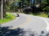
Here are some pics from my ride with my brother. All the water crossings were bone dry from the drought. :eek2:
 
Last edited:
So when are you guys going to do a TBDR?

Some ADV guys are putting together a nice G-map for the WBDR...
 
I was.

IMG1877Mod-L.jpg

Weekend before last.

No we have all this cold, white crap on the ground they call "snow"... :lol2:
 
I've looked at this map several months ago and thought it was great. One suggestion I have is rather than using placemarks to identify the roads is to actually draw a line along the road (when possible).

I think this would help in route planning a little more as you will have a better sense of where each segment starts and stops.

This is a big undertaking with all the placemarks currently on the map, but I can help.

I tried to give an example using your map, but Google Maps isnt cooperating. I saqved your map as a KML and then imported it into my own "My Places" so I can edit it, but itven though it says my changes are saved, when I close Maps and go back all my changes are gone.. ARGH!

Anyhow, here is an example of what I am talking about using completely different roads..

http://maps.google.com/maps/ms?ie=UTF&msa=0&msid=
216181760155631627378.0004aa0550da8bd0a5259
 
I tired doing that one time and it got really messy. Plus Google Maps would randomly move lines I had drawn making it more messy.

Great idea but I think the Google tools are lacking to keep it nice and clean.

My two cents... :thumb:
 
I've looked at this map several months ago and thought it was great. One suggestion I have is rather than using placemarks to identify the roads is to actually draw a line along the road (when possible).
[SNIP]
http://maps.google.com/maps/ms?ie=UTF&msa=0&msid=216181760155631627378.0004aa0550da8bd0a5259

I LOVE IT! So much easier to visualize and plan routes with. I'd be willing to help maintain / edit, if you could provide a primer on how to do it.

I don't understand the color coding; is one color pavement, something else dirt?

Also, I think it would be great to have one map entirely pavement, and another entirely dirt. Then, color coding on each could be used for difficulty, or fun-ness, construction (though that changes frequently). You can show more than one map at a time, so overlaying them both isn't a problem. This would keep both maps a little smaller and more focused.
 
I tired doing that one time and it got really messy. Plus Google Maps would randomly move lines I had drawn making it more messy.

Great idea but I think the Google tools are lacking to keep it nice and clean.

My two cents... :thumb:

Fair enough. :)

Looks like we both had problems in our own way.

Excellent work on compiling this anyhow!

I have to review some of my recent rides to see if I have anything to add. I think one of them is Althaus-Davis/Co 310 which I believe is already on the map. I also came across some up near Ft Hood that I found. I think one of those was Maxdale Rd. Since those roads are part of the base, firearms are prohibited.
 
Would love to go ride somewhere near where I live. I am in South Austin near Manchaca. Anything near there or Hays County area on the way to Buda/Kyle?
Looking for Dirt and Gravel and some water crossings are welcome!
Please HELP! :eat:
 
There isn't much within 20 miles either side of IH35. They have paved the world. You will need to go east a county or two and west the same.
 
I live east of Kyle in Maxwell. We have a dirt rd next to my house and I ride a 60-70 mile loop of asst dirt and paved/patched/potholed county rds in Caldwell and Bastrop counties. Plus Guadalupe and Gonzales counties aren't that far, and have plenty of gravel rds for exploring!
Hays and Blanco counties has paved most of its dirt rds in the last few years. There are some rural residential areas that still have gravel rds, mostly loops and dead ends but still interesting.
 
Would love to go ride somewhere near where I live. I am in South Austin near Manchaca. Anything near there or Hays County area on the way to Buda/Kyle?
Looking for Dirt and Gravel and some water crossings are welcome!
Please HELP! :eat:

Dude.......you need to hook up with us on one (or all) of the Austin Texas Hill Country Dual Sport Day Trips.

We will take care of that "dirtjones" for you.

Check this thread out...(just click it).....and look at the pics (on page 3).

Then stay tuned for the next ride. These are open to everyone.....and they are no drop rides.
 
digging this up...

there is so much info and data here now that i have a hard time finding exactly what i need.

I dont have my ADV bike anymore, but I do ride a Triumph scrambler that is in need of some dirt. I just need a route, that starts in north austin, and gets me dirty and fairly scenic. something around a half day ride? point me in some directions. Thanks! When I sold my Strom, I sold the GPS with it and all my cool routes where on it....im no good with remembering them!
 
Lookin for gravel roads from North Austin.... You're gonna hafta head to the west of 281 before ya find any non paved stuff out that way. Between Lampasas Lometa & San Saba up north... Llano to the west with a few scattered between there & south to Blanco (but mostly paved)

You'll have better luck closer in on the east side of 35.... Lots of gravel (& dirt) over there. Bastrop Giddings Elgin Taylor Rockdale Cameron Caldwell

I myself... prefer the skinny pavement so most of my riding is west of 35
 
The Doe Run route on the map is a PRIVATE ROAD. :eek2: I was out there today and talked to some homeowners and they asked me to post that this is NOT A PUBLIC ROAD and to please stay off. :giveup: The road has deteriorated since the April-May floods and the large hill is very rough especially if you are going the other way and trying to go down the hill. If you were to fall and get injured it is very hard to get an ambulance out there to get you out
Y'all can do as you wish, but I respect the owners rights and will stay away from this road. - Just sayin' :rider:
 
Last edited:
Lots and lots of gravel in my area but I'm an hour away from Austin

Signatures? We don't need no stinking signatures!
 
The Doe Run route on the map is a PRIVATE ROAD. :eek2: I was out there today and talked to some homeowners and they asked me to post that this is NOT A PUBLIC ROAD and to please stay off. :giveup: The road has deteriorated since the April-May floods and the large hill is very rough especially if you are going the other way and trying to go down the hill. If you were to fall and get injured it is very hard to get an ambulance out there to get you out
Y'all can do as you wish, but I respect the owners rights and will stay away from this road. - Just sayin' :rider:


? Not on our route :)
 
I just found this thread. I know I'm slow about this, but I'm starting to come to TWT more often and am learning to navigate it a little better. If you guys would expand your circle to 120 miles around Austin then it would include all of Coryell, Bosque and Hamilton counties. There are some awesome hill and valley roads in these counties. Low water crossing that actually run the road down into the creek or river bed (solid rock bottoms). I've just gotten my DS bike out of the shop and it's getting to be great riding weather. Most Sundays are open for me. I check ADVRider and TWT Monday thu Fridays. If anyone is out riding north of Austin, give me a shout and I'll try to meet ya'll ! ! !
 
Last edited:
Hey Dave, that stuff was all on the map originally, but Rod pulled it off a few years back. I don't recall the reason. here is a link to the DFW area map, which has some roads NE of Waco.

How's your neck? We need to ride sometime soon.

https://www.google.com/maps/@32.711...4b1!4m2!6m1!1sz0o71slnR7fc.kBo-yhe8vqGY?hl=en

If you want to be an editor on the DFW map, let me know.

I'm doing well thanks for asking. Yes we need to ride some. I haven't seen you in quite some time. I sold the BMW, had 83,000+ miles on it. Now Have the KTM 1290 Super Adventure. I have set it up for mainly street. I have Michelin Pilot Road 4's on it and they track so much better than the Continental Conti-Trail Attacks on pavement. I still have my KTM 950 Super Enduro and that's my off road bike. I've redone the suspension for my weight and right now it has TKC 80's on it. The only problem with the SE is range. It will make about 130ish miles on the tank. I carry a one gallon RotoPak which give me another 35 miles, if I'm riding easy on back country paved roads, it will get closer to 43+ mpg. So I'm always riding with a fuel stop planned ! ! ! :lol2:
 
Hey Dave, that stuff was all on the map originally, but Rod pulled it off a few years back. I don't recall the reason. here is a link to the DFW area map, which has some roads NE of Waco.

How's your neck? We need to ride sometime soon.

https://www.google.com/maps/@32.711...4b1!4m2!6m1!1sz0o71slnR7fc.kBo-yhe8vqGY?hl=en

If you want to be an editor on the DFW map, let me know.
Hey Dahveed..... youre memory serves you right.... I did remove all the mostly paved CRs that I had added to the Hill Country (Austin) Google map. Folks were complainin about how long it took to load the pages with all those roads. I originally moved some paved CRs to your DFW map but took them off again for the same reason (& other concerns I have mentioned to you before)

At some point I should prob do some sort of map for paved county roads in the more northern hill country region to augment the roads already shown on other maps.
 
Last edited:
Back
Top