• Welcome to the Two Wheeled Texans community! Feel free to hang out and lurk as long as you like. However, we would like to encourage you to register so that you can join the community and use the numerous features on the site. After registering, don't forget to post up an introduction!

The Roads of Texas, which is best?

Joined
Dec 29, 2017
Messages
7,076
Reaction score
4,486
Location
George West
First Name
Brian
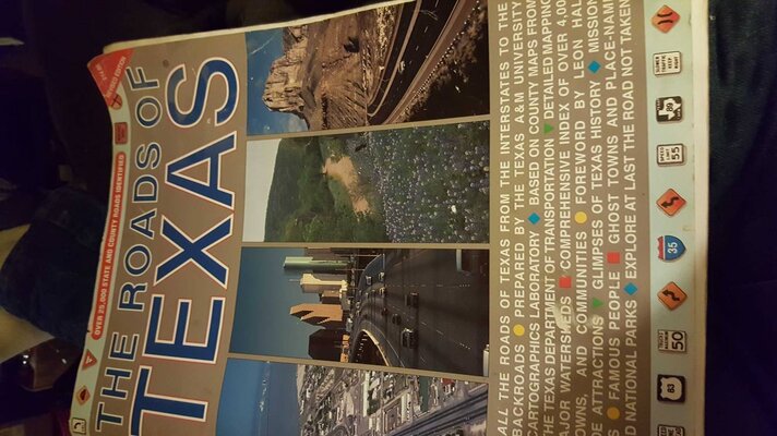
I have this one https://www.amazon.com/dp/0940672642/?tag=twowhetex-20
I notice it is latest copyright of 1995. There doesn't seem to be a later version

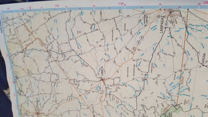
Then there's this one , Mapsco

https://www.amazon.com/dp/B00JPJHP46/?tag=twowhetex-20

Just wondering if the Mapsco is much better than the original roads o.t. , or maybe is based on the original? I see where the mapsco version is dated back to 2014

I guess Mapsco bought the rights so it's the same?? Hard to tell, can't see any page pictures on these Amazon sites (Amazon once was just a book seller believe it or not)
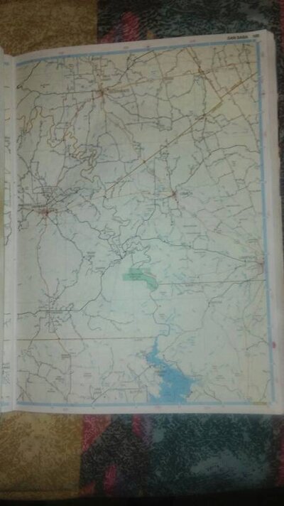
 
Where's our Tie Dyed seller of maps?

Hint: Butler Maps
Presently unaccounted for....

The older versions like 1995 & mabe 2005 had the best artwork...easier ta read in my opinion. The 2008 version I just bought does show more roads than before ...& the road info is more readable.... but...the artwork elevations & such suffers a bit
Still better than the newer spiral bound versions...I think.

Mapsco had already bought Shearer by 2008 & was making those updates that I mentioned. When the next version came out..it was spiral bound & even more cluttered in artwork & labeling. Still far far better than DeLorme Atlas & Gazetteer tho

& the older stapled versions are gettn harder ta find....
Several years ago I bought an extra 1995 version for $7-10 in good condition...bunches of em out there.
The 2008 I just bought cost me $25 used on fleabay in good cond.... But I saw other stapled versions used & new for $50-150! NUTS

Guess I needta start copyin pages again...keep the atlas at home & in good shape...instead of on the bike

Sent from my LGL62VL using Tapatalk
 
Last edited:
Presently unaccounted for....

The older versions like 1995 & mabe 2005 had the best artwork...easier ta read in my opinion. The 2009 version I just bought does show more roads than before ...& the road info is more readable.... but...the artwork elevations & such suffers a bit
Still better than the newer spiral bound versions...I think.

Mapsco had already bought Shearer by 2009 & was making those updates that I mentioned. When the next version came out..it was spiral bound & even more cluttered in artwork & labeling. Still far far better than DeLorme Atlas & Gazetteer tho

& the older stapled versions are gettn harder ta find....
Several years ago I bought an extra 1995 version for $7-10 in good condition...bunches of em out there.
The 2009 I just bought cost me $25 used on fleabay in good cond.... But I saw other stapled versions used & new for $50-150! NUTS

Guess I needta start copyin pages again...keep the atlas at home & in good shape...instead of on the bike

Sent from my LGL62VL using Tapatalk

Thanks, I guess I have the good one from 95' (stapled as you say) . My dad used to keep it handy to go find rigs when they wanted quick geophysical interpretation. I saved it and covered the front and back pages with that clear packing tape to help protect it. Really is best thing out there, albeit out dated.
 
Thanks, I guess I have the good one from 95' (stapled as you say) . My dad used to keep it handy to go find rigs when they wanted quick geophysical interpretation. I saved it and covered the front and back pages with that clear packing tape to help protect it. Really is best thing out there, albeit out dated.
Id like ta look at a 2005 version to see if its the same as 95 or 99 mostly

Sent from my LGL62VL using Tapatalk
 
Last edited:
Cleatus....does yours have the red ink county road labelling? & can you post a pic of the front cover

Sent from my LGL62VL using Tapatalk
Yes on the red numbering.
b2c94a0db73f5bcdaeb61b6a429c62cc.jpg


Sent from my SAMSUNG-SM-G890A using Tapatalk
 

Attachments

  • b2c94a0db73f5bcdaeb61b6a429c62cc.jpg
    b2c94a0db73f5bcdaeb61b6a429c62cc.jpg
    125.9 KB · Views: 284
Went to check my others and found full and half size '05/'08, plus one without cover, from before them but after the oldest.
Ahhhh.... My cover is the same 1999 so the separate bound pages must also be the 99 with the red printing. My older one which I lost mustve been the 95...without county road labelling. Is the artwork on your 05 the same as the 99? ..or like the 08..with a bunch more county roads shown....paved with a thin solid line...unpaved a wider hash line. But lacking the light yellow background & busier overall in detail.

Some of the indicated paved roads on my 08 Roads Of Tx...are actually gravel now. But I do kno that at least a few were paved previously cuz I usta ride them. The CR numbers are also still not updated in Lampasas County...2 digits instead of the current 4

Sent from my LGL62VL using Tapatalk
 
Last edited:
Ahhhh.... My cover is the same 1999 so the separate bound pages must also be the 99 with the red printing. My older one which I lost mustve been the 95...without county road labelling. Is the artwork on your 05 the same as the 99? ..or like the 08..with a bunch more county roads shown....paved with a thin solid line...unpaved a wider hash line. But lacking the light yellow background & busier overall in detail.

Some of the indicated paved roads on my 08 Roads Of Tx...are actually gravel now. But I do kno that at least a few were paved previously cuz I usta ride them. The CR numbers are also still not updated in Lampasas County...2 digits instead of the current 4

Sent from my LGL62VL using Tapatalk
In chronological order the last having 4 number roads in Lampasas


7de234980c8d3a0cc09525dc622c84cb.jpg


Sent from my SAMSUNG-SM-G890A using Tapatalk
 

Attachments

  • 7de234980c8d3a0cc09525dc622c84cb.jpg
    7de234980c8d3a0cc09525dc622c84cb.jpg
    163.3 KB · Views: 223
In chronological order the last having 4 number roads in Lampasas


7de234980c8d3a0cc09525dc622c84cb.jpg


Sent from my SAMSUNG-SM-G890A using Tapatalk
Huh??! None of mine are spiral bound....even the 08.
Mabe Mapsco offered both at the same time...or switched bind during ???

Sent from my LGL62VL using Tapatalk
 

Attachments

  • 7de234980c8d3a0cc09525dc622c84cb.jpg
    7de234980c8d3a0cc09525dc622c84cb.jpg
    163.3 KB · Views: 280
05 the major highways are bold black lines

Aaron
So.... Im thinkin....the 99 has old style Shearer Publishing artwork which is nice & easy to see... But very small red labels on county roads. (Keep in mind that Ive highlighted some CRs with blue on this one)
9b2c14137a7ac3c80bd120936a619567.jpg

The 05-08 versions have different artwork...more county roads & bigger labels... But slightly busy
e66146e09129f84c652805e6d7200e38.jpg

The newest versions have even busier artwork (I think)... more info...yes...but harder to read. Possibly bought from Mapsco by Universal Map or another company

Here is the 99 & 08 side by side. Not a lot of difference...but 99 is still more readable to me.
5d4f15b1f64ee7aff8049c337d64dcb3.jpg
 

Attachments

  • 9b2c14137a7ac3c80bd120936a619567.jpg
    9b2c14137a7ac3c80bd120936a619567.jpg
    33 KB · Views: 276
  • 5d4f15b1f64ee7aff8049c337d64dcb3.jpg
    5d4f15b1f64ee7aff8049c337d64dcb3.jpg
    42.3 KB · Views: 279
  • e66146e09129f84c652805e6d7200e38.jpg
    e66146e09129f84c652805e6d7200e38.jpg
    38.6 KB · Views: 275
Last edited:
I have noticed the early wire bound issue looks like it went to press without being proofread , on most pages there will be a county with areas that don't have any county roads numbered . Also the contrast on the old stapled version seemed to be much easier on old eyes . We won't even get started on the delorme maps .
 
I have noticed the early wire bound issue looks like it went to press without being proofread , on most pages there will be a county with areas that don't have any county roads numbered . Also the contrast on the old stapled version seemed to be much easier on old eyes . We won't even get started on the delorme maps .
Hazards of gettn bought up by a large corporate.... ( dunno...Not my job)

Sent from my LGL62VL using Tapatalk
 
Well... you know what they say, opinions are like...

I'm thinking I like the white page style. I have squinted over those yellow pages a while , later editions looks refreshing to me

Thanks everyone for all the excellent information. :thumb:
 
In all this talk of maps...I have wondered before why no one here has mentioned Key Maps.

I thought Key Maps had gone the way of the dodo. A quick google later..., still alive and kicking, I just never realized they are limited to SE Texas: Harris, Montgomery, Waller and liberty counties.

We (fedex couriers) used them extensively. Indispensable for rural routes. I'm sure they are still used today.

They are incredibly detailed, include all roads and tracks and features like oil wells and windmills. Roads of Texas got nothing on a KeyMap.

Too bad they don't map the entire state!
Ive seen those before Gina...& yes...yes they are very detailed.... I thought they were extinct too....definately wish they had more coverage

Sent from my LGL62VL using Tapatalk
 
Back
Top