
 Feel free to hang out and lurk as long as you like. However, we would like to encourage you to
 Not Dave
Technically I AM Dave
- Joined
- Sep 2, 2011
- Messages
- 2,608
- Reaction score
- 707
- Location
- Taylor, TX
- First Name
- David
- Last Name
- Hogate
I meant to do this upon my return from the trip in May 2018 but for reasons unknown (yeah, that's it) this story hasn't been published until now (February 2019).
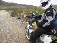
The 2018 Overland Expo West was in Flagstaff, AZ, in May. I had never been, thought it might interest me so decided I'd attend. I tried the year before but had a family emergency that took its place instead. My wife was not to join me on this trip and I was to do it alone. My idea was to throw the '07 Suzuki DR650 in the back of my truck and head out. Planning the year before for the same trip I had decided to stay pretty much the same route. My plan to ride was only in Flagstaff, AZ, so the bike stayed in the truck until I got there (hence why this isn't a "ride report").
Along the way I wanted to see:
Very Large Array, i.e., National Radio Astronomy Observatory in NM,
Chaco Culture National Historic Site in NM,
Canyon de Chelly National Monument in AZ,
Four Corners (pick your state - AZ, UT, NM, CO),
Monument Valley in AZ & UT.
Heading out from the Austin, Tx, area on the first day (Monday, May 14, 2018) my goal was to drive to Ruidoso, NM, and head up to the Skyline Campground in the Lincoln National Forest. The drive through NW Texas is spectacular, said no one ever, but I made it to NM in the normal amount of time taking Hwy 380 just south of Lubbock into Roswell where I had a Blizzard at a Dairy Queen. I love the Oreo Blizzards. I then proceeded to Ruidoso where I planned to eat dinner before heading up to the campground which is at 9,000 feet. At Hondo, NM, I turned off to Hwy 70 which turned out to be a very scenic drive in the afternoon. Dinner turned out to be a a biker bar of sorts at a joint called Anaheim Jacks. It was OK. I was the only one there at first which got me worried, thinking I may have a trip to the loo later that evening but then others came in and began to order food too. I don't know why I didn't get a hamburger and fries but opted for fish 'n chips. Live and learn but at least it didn't upset me. Off to the campground.
I got to the Skyline Campground after sunset. The road up the mountain is dirt and somewhat nice in most parts but not all parts. There had previously been a large scale forest fire and it was noticeable. Still patches of trees around though. First I get to the top and try to see what I can see from the Monjeau Peak lookout. It was almost dark so headed to put up camp. Good thing I was the only person there so didn't bother anyone with my snoring later that night. The morning hit fairly early as I slept like a baby in the cool mountain air.


Day 2. Woke up to a beautiful sunrise. Broke down camp, loaded up my stuff and headed out. Just down the mountain a bit were some wild horses.

With the goal of driving to Socorro, NM, for lunch then toward Datil, NM, where the Very Large Array is. You can walk around, they have some neat stuff to look at and a decent museum. On the way I passed over the Malpais lava flow which they estimate occurred about 5,000 years ago.

Socorro was fine and I hit the Walmart, Arby's and got some fuel. Now west to the Very Large Array.


After that I headed west some more to pick up Hwy 60 to Pie Town then north on 117 toward Grants and IH 40. What I didn't do was research to see what was on 117. As I drove north the scenery got nice again as I entered the El Malpais National Monument. Here I found one of the largest natural arches at La Ventana just north of The Narrows. This is also part of the Continental Divide Trail.


My plan was to stay in the Gallo campground at Chaco Culture that evening. Because I keep stopping at places and looking around I made it there late in the afternoon. The campground was full. Oh well. Back to IH 40 and to Gallup, NM, for dinner then off to Chinle, AZ for a stay in a hotel. That hotel is just outside the west entrance to Canyon de Chelly.
Day 3. After checking out of the hotel and making sure the motorcycle and other gear were secure I proceeded to the entrance of Canyon de Chelly. Like I always do I stop at every view point and take pictures. I noticed a few hours into this that I hadn't reached Spider Rock yet but had to get to Four Corners and Monument Valley today. Before I left I hiked down to the canyon floor to get up close to these cliff dwellings called White House.


Even some visitors in the 1800's were turds. This was roughly a decade after the US Army first entered the canyon which set off events that ended in the Long Walk.


Off to Four Corners. It took several hours of driving. I did walk around it so hit all 4 States in less than 5 seconds. Took a while for this pic as a family was hogging it for ten minutes taking numerous pics.

I figured out that I also had a tail light out so wanted to get a new bulb before night time hit. Using Google Maps on my phone the nearest place to go was Cortez, CO. I took the liberty to also pick up some D cell batteries for a camp light I have. Nice little town but that added some time to my trip to Goulding's campground at Monument Valley. I still got there with daylight to spare.


Day 4. I opted to do the self-driving tour of Monument Valley. You enter in UT and quickly get into AZ. It was fantastic.


After I had taken several hours to drive around and take yet more photos I headed south to Hwy 160 then to Hwy 89. I believe I had lunch in Tuba City at a Subway. Filled up with fuel and on to Flagstaff. The line getting into the park where Overland Expo was was long but only took about an hour to get in and to my campsite. 12 others would be in the same campsite with 7 rigs. We all got to know each other and got along well.
Day 5. I didn't go into the Expo but instead hopped on the DR and headed into Flagstaff for lunch. After lunch I headed north to Wupatki for some Indian ruins. The park road there was fantastic! Nearly no one on it, smooth and long sweeping curves, valleys and hills. I took it clockwise and ended up at Sunset Crater Volcano National Monument. My camera battery died just before then so used my cell phone for pics. I forgot to bring the extra battery.


Back to camp and relax. That was a good day riding. I did find McGaugh's which has a lot of craft beer so bought some and brought it back to camp to enjoy that evening with my grilled burgers.
Day 6. Didn't go into the expo again but instead rode to Walnut Canyon National Monument. I got there via a great dirt road off the Continental Golf Club. Walnut Canyon has cliff dwellings but they're different than what you normally think of cliff dwellings. It's a hike too, lots of stairs, but what a great day. The weather in Flagstaff was phenomenal, couldn't ask for any better.

After riding back to town I had some BBQ dinner then back to camp.
Day 7. I finally perused the expo. Took a whole hour to walk around and didn't stop at any vendors places. Several of us from the camp did go to the bar area where they had craft beer and we had some.
Day 8. I headed back to NM and to Chaco Culture. I did stay at the campground that evening. It was nice.


Day 9. Originally I had planned to drive back to TX and stay at Balmorhea State Park but decided to just drive home. I did pass through Fort Sumner, NM, which is the area that the Navajo ended up in after the Long Walk. Continued home, almost 900 miles but did it. My wife was happy I was home a day early and so was I. That was a lot of driving but I enjoyed every minute of it. Except NW Texas. That's boring as Hades.
There were many more photos but I figured a lot of them don't mean much if you weren't there and I'm not describing what you're seeing. I read up on history of the locations I went to. I'm not an American Indian buff but I do like American history. The expansionists, especially President Polk, really took a lot of land and nearly destroyed Native American's cultures. They just weren't compatible but the American's had more people and better equipment. Chaco Canyon though was deserted by Anasazi most likely due to a years-long drought. They were farmers and relied on agriculture.
Hope you enjoyed my little write up.
Not Dave
The 2018 Overland Expo West was in Flagstaff, AZ, in May. I had never been, thought it might interest me so decided I'd attend. I tried the year before but had a family emergency that took its place instead. My wife was not to join me on this trip and I was to do it alone. My idea was to throw the '07 Suzuki DR650 in the back of my truck and head out. Planning the year before for the same trip I had decided to stay pretty much the same route. My plan to ride was only in Flagstaff, AZ, so the bike stayed in the truck until I got there (hence why this isn't a "ride report").
Along the way I wanted to see:
Very Large Array, i.e., National Radio Astronomy Observatory in NM,
Chaco Culture National Historic Site in NM,
Canyon de Chelly National Monument in AZ,
Four Corners (pick your state - AZ, UT, NM, CO),
Monument Valley in AZ & UT.
Heading out from the Austin, Tx, area on the first day (Monday, May 14, 2018) my goal was to drive to Ruidoso, NM, and head up to the Skyline Campground in the Lincoln National Forest. The drive through NW Texas is spectacular, said no one ever, but I made it to NM in the normal amount of time taking Hwy 380 just south of Lubbock into Roswell where I had a Blizzard at a Dairy Queen. I love the Oreo Blizzards. I then proceeded to Ruidoso where I planned to eat dinner before heading up to the campground which is at 9,000 feet. At Hondo, NM, I turned off to Hwy 70 which turned out to be a very scenic drive in the afternoon. Dinner turned out to be a a biker bar of sorts at a joint called Anaheim Jacks. It was OK. I was the only one there at first which got me worried, thinking I may have a trip to the loo later that evening but then others came in and began to order food too. I don't know why I didn't get a hamburger and fries but opted for fish 'n chips. Live and learn but at least it didn't upset me. Off to the campground.
I got to the Skyline Campground after sunset. The road up the mountain is dirt and somewhat nice in most parts but not all parts. There had previously been a large scale forest fire and it was noticeable. Still patches of trees around though. First I get to the top and try to see what I can see from the Monjeau Peak lookout. It was almost dark so headed to put up camp. Good thing I was the only person there so didn't bother anyone with my snoring later that night. The morning hit fairly early as I slept like a baby in the cool mountain air.
Day 2. Woke up to a beautiful sunrise. Broke down camp, loaded up my stuff and headed out. Just down the mountain a bit were some wild horses.
With the goal of driving to Socorro, NM, for lunch then toward Datil, NM, where the Very Large Array is. You can walk around, they have some neat stuff to look at and a decent museum. On the way I passed over the Malpais lava flow which they estimate occurred about 5,000 years ago.
Socorro was fine and I hit the Walmart, Arby's and got some fuel. Now west to the Very Large Array.
After that I headed west some more to pick up Hwy 60 to Pie Town then north on 117 toward Grants and IH 40. What I didn't do was research to see what was on 117. As I drove north the scenery got nice again as I entered the El Malpais National Monument. Here I found one of the largest natural arches at La Ventana just north of The Narrows. This is also part of the Continental Divide Trail.
My plan was to stay in the Gallo campground at Chaco Culture that evening. Because I keep stopping at places and looking around I made it there late in the afternoon. The campground was full. Oh well. Back to IH 40 and to Gallup, NM, for dinner then off to Chinle, AZ for a stay in a hotel. That hotel is just outside the west entrance to Canyon de Chelly.
Day 3. After checking out of the hotel and making sure the motorcycle and other gear were secure I proceeded to the entrance of Canyon de Chelly. Like I always do I stop at every view point and take pictures. I noticed a few hours into this that I hadn't reached Spider Rock yet but had to get to Four Corners and Monument Valley today. Before I left I hiked down to the canyon floor to get up close to these cliff dwellings called White House.
Even some visitors in the 1800's were turds. This was roughly a decade after the US Army first entered the canyon which set off events that ended in the Long Walk.
Off to Four Corners. It took several hours of driving. I did walk around it so hit all 4 States in less than 5 seconds. Took a while for this pic as a family was hogging it for ten minutes taking numerous pics.
I figured out that I also had a tail light out so wanted to get a new bulb before night time hit. Using Google Maps on my phone the nearest place to go was Cortez, CO. I took the liberty to also pick up some D cell batteries for a camp light I have. Nice little town but that added some time to my trip to Goulding's campground at Monument Valley. I still got there with daylight to spare.
Day 4. I opted to do the self-driving tour of Monument Valley. You enter in UT and quickly get into AZ. It was fantastic.
After I had taken several hours to drive around and take yet more photos I headed south to Hwy 160 then to Hwy 89. I believe I had lunch in Tuba City at a Subway. Filled up with fuel and on to Flagstaff. The line getting into the park where Overland Expo was was long but only took about an hour to get in and to my campsite. 12 others would be in the same campsite with 7 rigs. We all got to know each other and got along well.
Day 5. I didn't go into the Expo but instead hopped on the DR and headed into Flagstaff for lunch. After lunch I headed north to Wupatki for some Indian ruins. The park road there was fantastic! Nearly no one on it, smooth and long sweeping curves, valleys and hills. I took it clockwise and ended up at Sunset Crater Volcano National Monument. My camera battery died just before then so used my cell phone for pics. I forgot to bring the extra battery.
Back to camp and relax. That was a good day riding. I did find McGaugh's which has a lot of craft beer so bought some and brought it back to camp to enjoy that evening with my grilled burgers.
Day 6. Didn't go into the expo again but instead rode to Walnut Canyon National Monument. I got there via a great dirt road off the Continental Golf Club. Walnut Canyon has cliff dwellings but they're different than what you normally think of cliff dwellings. It's a hike too, lots of stairs, but what a great day. The weather in Flagstaff was phenomenal, couldn't ask for any better.
After riding back to town I had some BBQ dinner then back to camp.
Day 7. I finally perused the expo. Took a whole hour to walk around and didn't stop at any vendors places. Several of us from the camp did go to the bar area where they had craft beer and we had some.
Day 8. I headed back to NM and to Chaco Culture. I did stay at the campground that evening. It was nice.
Day 9. Originally I had planned to drive back to TX and stay at Balmorhea State Park but decided to just drive home. I did pass through Fort Sumner, NM, which is the area that the Navajo ended up in after the Long Walk. Continued home, almost 900 miles but did it. My wife was happy I was home a day early and so was I. That was a lot of driving but I enjoyed every minute of it. Except NW Texas. That's boring as Hades.
There were many more photos but I figured a lot of them don't mean much if you weren't there and I'm not describing what you're seeing. I read up on history of the locations I went to. I'm not an American Indian buff but I do like American history. The expansionists, especially President Polk, really took a lot of land and nearly destroyed Native American's cultures. They just weren't compatible but the American's had more people and better equipment. Chaco Canyon though was deserted by Anasazi most likely due to a years-long drought. They were farmers and relied on agriculture.
Hope you enjoyed my little write up.
Not Dave
Last edited by a moderator: