• Welcome to the Two Wheeled Texans community! Feel free to hang out and lurk as long as you like. However, we would like to encourage you to register so that you can join the community and use the numerous features on the site. After registering, don't forget to post up an introduction!

Where In The World Is Tracker?

A "non-ride" day in Lake City. Did a short sunrise ride out around Lake San Cristobol. It's a tough job, but somebody's got to do it. :rider: Just wish I had a Strom at this point as the Speed Triple's not much fun on dirt, even if it's hard-pack. Glad I had the jacket liner and the winter gloves.

thu25am03.jpg


thu25am02.jpg


thu25am01.jpg
 
I like rest days. These are shots taken going towards Engineer's Pass and Cinnamon Pass. Bob said the passes usually close some time in the first two weeks of October when they'll get a 3 foot snow at elevation. Peak foliage is usually Sept 20 +/- 5 days. He thought it peaked today because they had a late arrival of spring.

The hummingbird moth was back at the lodge. The hummingbirds have already left for the season.

thu25pm04.jpg


thu25pm03.jpg


thu25pm05.jpg


thu25pm01.jpg


Tomorrow, the horse begins to head for the barn. :tears:
 
Last edited:
You're doing a great job Gary.

Love the photos. :thumb:

Mind the whip. The old mare is already eager enough. ;-)
 
Friday
Well, it was time to load up the old mare and head east and south.

A pic from their front drive, ready to roll. The big Cabella's dry bag (the green one) works great.

200809frisun2729006.jpg


I said goodbye to my good friends and slowly headed south and east out of Lake City. It took me an hour to go 19 miles from stopping so many times to take pics. It's hard to describe the intensity of the beauty of it all--the mountains combined with the fall colors of the aspen, the crisp, cool air. At the risk of losing a corner off my man-card, I was brought to tears at one point it was that intense. God's creative hand is amazing.

200809frisun2729010.jpg


200809frisun2729011.jpg


Umcompagre Peak is the tallest of the mountains.
200809frisun2729012.jpg


I eventually wound my way to the county seat of Mineral County, near the headwaters of the Rio Grande. I think their motto is Old trailer houses don't die; they just move here. Once you get out of town, you get a different take on the Rio Grande.

200809frisun2729015.jpg


200809frisun2729016.jpg


The Lord had mercy on me and I threaded through numerous rain showers with hardly a drop.

200809frisun2729018.jpg


200809frisun2729019.jpg


I turned south off 180 and passed by this lake just north of Monument Park.

200809frisun2729024.jpg


Continuing on, through Stonewall to my final destination for the day, just west of Trinidad.

I've always enjoyed photographing old church steeples. Here's a couple along the way to Trinidad.

200809frisun2729028.jpg


200809frisun2729030.jpg


When a stake just won't go into the ground.

200809frisun2729042.jpg
 
Sat
Sunrise over Lake Trinidad from the State Park.

200809frisun2729040.jpg


I decided to finally stop after all these years of passing the Capulin Volcano on my trips between TX and CO. It was my lucky day! "National Lands Day" and no entrance fee (normally $5). Nice view from the top.

200809frisun2729044.jpg


200809frisun2729046.jpg


Heading on through Folsum, I ran across this old, abandoned motel.

200809frisun2729049.jpg


200809frisun2729050.jpg


Pressing on into the Texas panhandle, I entered through Texline.

Later, I had to stop and take a pic of this motel. I stayed here in 1981 on my cross-country bicycle trip. It appears to be long abandoned, having been bypassed by the Interstate. It was the classic "motor court" with carports to park you car in next to your room.

200809frisun2729058.jpg


Caprock Canyon SP would be my stop for the night. If you ever go there, be sure to go all the way to the back of the park (North Prong Campground), or you'll miss out on the best features. This shot is from my campsite for the night.

200809frisun2729077.jpg


Now, these are TEXAS size ants.

200809frisun2729090.jpg


A "UFO" seen from my campsite.

ufo.jpg


The last campfire of the trip. :tears:
200809frisun2729101.jpg


Tomorrow, the last leg.
 
Sunday
This was one of the hardest days, physically. The heat increased throughout the day. My body didn't want to go back to prairie land, and neither did my mind.

Leaving Caprock and pressing on east, then south, I passed this landmark.

200809frisun2729109.jpg


Coming off the High Plains
200809frisun2729110.jpg


I didn't see one Harley, but I did see two coyotes and a mule doe.
200809frisun2729112.jpg


The last leg was torture, but I was home.
 
The Official Time Clock Is Now Counting Down For Witwit

THE OFFICIAL TIME CLOCK IS NOW COUNTING DOWN FOR WITWIT.

You have 24 hours to send me your PM with your best guess as to how many miles it took me to accumulate this many bugs and win that fabulous TWT T-Shirt. No guesses after 21:34 on Monday, September 29, 2008 will be accepted. If you create your own google map and draw a point to point line, it will automatically figure the distance for you. Good luck.

200809frisun2729001.jpg


I will post all the guesses along with the winning guess and also a route log and mileage tomorrow night.
 
I didn't realize my story telling was THAT bad. :lol2:
Only one PM so far for the t-shirt contest.
 
A most good ride report and pics about seeing some beautiful country and fall colors.
How long have you had your sunglasses? They look like the same in the before and after pics!
Neal
 
I hate it when I throw a party and nobody comes. :oops:

odo start: 17119
odo finish: 19851
trip: 2732

donroger1: 2734 (scary close; queue Twilight Zone music) and T-shirt winner
Gilk51: 2361
Eltee: 3607


My original google map estimated it at 2200 miles. I'm not sure I would have done it if I'd have known it would be 2700 miles, but I'm glad I did.

TRIP LOG
SAT 370 mi
1171 to 377N
377N to 407W
407W to 287/81N
380W thru Decatur, Bridgeport, Graham, Throckmorton, Haskell, Aspermont
208S to Snyder
208B to CO City
163S in CO City
RR2830 right to Park

SUN 405 mi
163 to I20W to Big Spring
87N to Lamesa
180W thru Seminole, Hobbs, NM
529W to 82W
82W thru Loco Hills, Artesia, Hope, Cloudcroft
54/70S to 70S in Alamagorda
70S past White Sands
15mi East of Las Cruces, turn into Aguirre Springs Campground (BLM)
6 mi south to campground

MON 400 mi
70W into Las Cruces
past 85/20 to 185N
185N to Hatch
187N in Hatch to 86/20
152W thru Hillsboro (twistiest stretch I was on), San Lorenzo to Santa Clara
180W thru Silver City, Cliff, Buckhorn
180W/78 Pleasanton
12N/E to Apache Creek
32N to Quemado
36/117 to 117N
117N to I40W to Grants

TUE 369 mi
I40 W to Thoreau
371N thru Smith Lake, Crownpoint to Farmington
E. Main in Farmington to 516N to Aztec
550N thru Bondad, CO, Durango, Silverton (twisty, but heavy traffice), Ouray, Dallas to Montrose
50N in Montrose, thru Delta
50/70 in Grand Junction to 340/W Broadway to friends house

WED 197 mi
340E/Broadway to 50/70 South
50S thru Delta to Montrose, then 50E towards Gunnison
149S to Lake City just after Blue Mesa Lake

THU 13 mi
rest day

FRI 253 mi
149 thru Creede
160E at South Fork, thru Del Norte, Monte Vista, Alamosa, Muleshoe
12S thru La Veta, Stonewall to Trinidad SP

SAT 387 mi
12E to I-25S thru Raton
87E to Capulin,
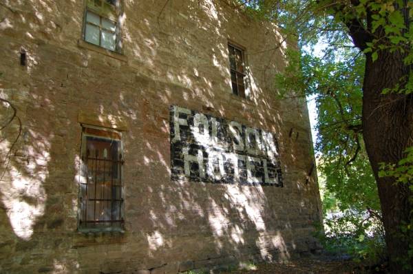
325N to Capulin Monument, Folsom
72S to Des Moines
87E thru Clayton, Texline, Dalhart
87/385 to Channing
385 thru Vega, Hereford to Dimmit
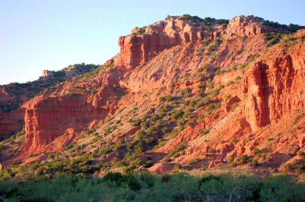
86E thru Nazareth, Tulia, Silverton, Qutaque to Caprock Canyon SP (bad mosquitoes)

SUN 348 mi
86E to Turkey
70S to Matador
70/62E thru Paducah to Crowell
6S to Benjamin
82/114E thru Seymour
114E thru Olney, Loving, Jacksboro
380 to Decatur,
81/287 S to 407E thru Justin
377S to 1171 to GWB Tollway to home


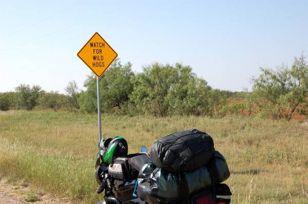
Any mileage over 325 on the Speed Triple brings flashbacks of the Spanish Inquisition. I turned into a squid at times, standing on my pegs to "air out".
 
I have been to Lake City for a grand total of 6 hours in my 27 years, and I think it may be one of my favorite towns. Not so much for the town itself, but its location is nothing short of amazing.
 
trip: 2732

donroger1: 2734 (scary close; queue Twilight Zone music) and T-shirt winner
Gilk51: 2361
Eltee: 3607

Isn't this one of those "closest but not over" contests like The Price is Right? ;-)

I knew I should have thrown in a couple hundred miles for day trips but that still wouldn't have done it...

I think Denton Don cheated or needs to get back to work... :lol2:
 
I have been to Lake City for a grand total of 6 hours in my 27 years, and I think it may be one of my favorite towns. Not so much for the town itself, but its location is nothing short of amazing.


I first went there as a kid @ 11 yrs old. That was my first trip to the mountains as a TX boy, and it gave me a lifelong love for the mountains. Went back with the family at 15, then 4 more times counting this time. Real estate there is now crazy. $250-300K for a small cabin on a 1/2 acre lot. In the late 60's, they were selling lots in town across the river for $15 ea., and they couldn't give them away. :doh:
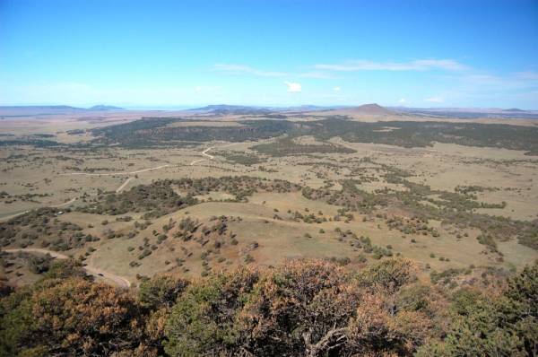
Hinsdale county has something like 97% public land, so private land is very scarce.
 
Is that the Lake City where the armory was located?

I have a couple of OD bandoleers (sp?) with LC on them but never knew where that was...
 
Is that the Lake City where the armory was located?

I have a couple of OD bandoleers (sp?) with LC on them but never knew where that was...

If it is, I've never seen or heard of it. Maybe a Lake City in another state? :shrug:
 
If it is, I've never seen or heard of it. Maybe a Lake City in another state? :shrug:

Yeah - a little Google & I found Lake City Army Ammunition Plant (LCAAP) near Independence, Mo. - a small caliber production facility.

I suspect it is more scenic where you were... ;-)
 
I know many of you have lots of experience taking high mileage trips, etc. Hopefully, my observations of being on the road for 9 days straight/2700 miles will help others who've never gone this far in one trip

  • 400 miles in one day is a looong way on a Speed Triple. I did two back to back. My previous longest day was 325 miles.
  • Don't forget to adjust your suspension for the added load.
  • A rest day is helpful after the third or fourth day.
  • Even in the fall, campsites can be scarce on the weekends.
  • Cover your plastics/painted surfaces with either electrician's tape or packing tape anywhere that a bag/gear might contact it. Even secured, rub marks can occur after a full day's ride.
  • A tennis elbow strap makes a halfway decent throttle lock.
  • If most of your riding is short hops and your doing all day, higher speed/RPM riding than normal, check your oil level more often. My S3 never uses oil commuting, but it used about a 1/2 a quart in 1500 miles on this trip. Typical RPms are 3-4K for commuting. My average RPM on the highway for hours on end was 5-6K.
  • No matter how many times you pack, each morning, you end up doing it just a little bit differently. :giveup:
  • Don't forget chain lube if the distance requires it.
  • Don't count on good cell coverage in the boonies, no matter what the coverage map seems to say.
  • Ear plugs work in the tent, too, if somebody's a little too rambunctious in the campground.
  • A cold brew sure tastes good after a long day on the road. Just be careful in the State Parks. Most don't allow open consumption. Be smart; be discrete.
  • Leave your campsite a little cleaner than you found it. You'll be a better person for it.
 
Yeah - a little Google & I found Lake City Army Ammunition Plant (LCAAP) near Independence, Mo. - a small caliber production facility.

I suspect it is more scenic where you were... ;-)

:tab Lake City Army Ammunition Plant

:tab Just north of Blue Springs, MO. (my mother lives there)

:tab Don't the bunkers make a "denture looking" happy face??? (in satellite view) :lol2:
 
A most good ride report and pics about seeing some beautiful country and fall colors.
How long have you had your sunglasses? They look like the same in the before and after pics!
Neal
The old picture from '84 were RayBan Shooters, if I'm not mistaken. I could still see without prescriptions, then. Now, :shock:, gotta have prescriptions specs all the time.
 
Panorama from US 160 in eastern CO looking towards Muleshoe

(tips on stitching photos together in paint.NET gladly taken)

panorama_180_CO800x200.jpg
 
Last edited:
Gary, what is most good about the whole 'adventure', is for any two wheeled rider to strike out on their steed and absorb the beauty of the land, the atmosphere and the people along the way. You have shared your story and some good pics for all to enjoy and probably influence other riders to do something similar. No matter that the route # maybe misnumbered, just enjoy the journey and wherever your are from the saddle. Neal
 
Back
Top