Feel free to hang out and lurk as long as you like. However, we would like to encourage you to
 _RG_
Forum Supporter
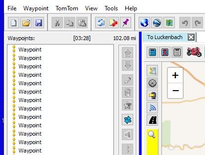
Good to read about yall's experiences with these new options. While back folks talked about revit. I tried it and it stunk. Couple years later they used it for navigation around breckinridge during the ktm rally. It worked great. Things change. I'm still stuck in the stone age using g earth, mapsource, mvum overlays, openstreets and a collection of aging gps topo maps...with an occassional brief and apprehensive dalliance into basecamp. It all still gets me where I want to go...eventually. If I was riding pavement there are way better options than this convoluted digital haystack.